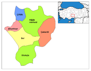
Bor, Niğde
| Bor | |
|---|---|
 | |
 Bor | |
| Coordinates: 37°53′00″N 34°34′00″E / 37.88333°N 34.56667°ECoordinates: 37°53′00″N 34°34′00″E / 37.88333°N 34.56667°E | |
| Country |
|
| Province | Niğde |
| Government | |
| • Mayor | Sıtkı Erat (AKP) |
| • Kaymakam | Şenol Bozacıoğlu |
| Area[1] | |
| • District | 1,268.90 km2 (489.93 sq mi) |
| Population (2012)[2] | |
| • Urban | 40,472 |
| • District | 60,950 |
| • District density | 48/km2 (120/sq mi) |
| Website | www.bor.bel.tr |
Bor is a town and district of Niğde Province in the Central Anatolia region of Turkey, 14 km (8.7 mi) north of the city of Niğde, on a high plain (altitude 1,100 m (3,600 ft)). The district's population is 59,919 of which 38,320 live in the town of Bor.[3]
The area is situated just north of the Taurus Mountains, not far from the Cilician Gates (Gülek Boğazı), the mountain pass leading to Cilicia and Syria, and has long been a place of commercial and military importance.
Etymology
The Hittites and Assyrians gave the area the name Tuwanuwa. In the times of Cyrus the Younger and Alexander the Great it was named Dana and then by the Romans, Tyana, (Θυάνα in Ancient greek). The remains of these civilizations can be found in the village of Kemerhisar. Bor is a more modern settlement nearby.
History
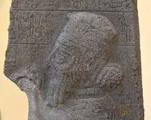
The plain has been settled since the time of the Hittites, and subsequently controlled by Assyrians, Phrygians, Persians and Ancient Macedonians. The Romans (and from 395 AD onwards Byzantium) built the ancient city of Tyana the most southern-most centre of Cappadocia. During the Byzantine period the town was the eastern Mediterranean region’s most important Christian centre, as indicated also by its former Turkish name of Kilisehisar (‘City of the Churches’).
Turks began to settle in the area in the wake of the Battle of Manzikert after 1071. In the course of time the fortifications of ancient Tyana vanished among the towns of Bor, Kemerhisar and Bahçeli.
Today the economy of Bor depends on grazing animals, plus some carpet weaving and leather-making. The countryside is too dry for planting crops, although there are vineyards and orchards (mainly apple and apricot) in Kemerhisar. This is a relatively poor district and many people have migrated to Europe or the larger cities of Turkey in search of jobs.
Places of interest
- Alâeddin Bey (Ulu Cami) Mosque - on the riverbank in the town centre.
- Şeyh İlyas or Kale Camii - 16th century Ottoman mosque.
- The rocks where the Hittites worshipped the storms gods, in the village of Gökbez.
- The ruins of Tyana (ancient Tuvanuva, Dana, Tyana) and a number of Roman waterways scattered over three hills between the villages of Bahçeli and Kemerhisar. These include the remains of a complex of Roman baths (Roma Hamamı) and a limestone aqueduct dated from the reign of Caracalla (211-217 A.D.). The original supply of the aqueduct, the monumental pool of Bahçeli (Roma Havuzu, 5.5 km NE) is still well preserved. It sits at the foot of Köşk Höyük, a Hittite settlement excavated in 1981 that is turning out to be of great historical value. There are also other massive foundations of several large buildings, shafts, pillars, and one handsome column (replaced) still standing.
- The mineral water and therapeutic mud-baths just south of Kemerhisar. The hot spring (15°C) mentioned in ancient writings still bubbles into a cold swamp. The mineral water is drunk for its healing powers and the site (İçmeler) also includes a bathing pool.
References
Falling Rain Genomics, Inc. "Geographical information on Bor, Turkey". Retrieved 2008-03-14.
- ↑ "Area of regions (including lakes), km²". Regional Statistics Database. Turkish Statistical Institute. 2002. Retrieved 2013-03-05.
- ↑ "Population of province/district centers and towns/villages by districts - 2012". Address Based Population Registration System (ABPRS) Database. Turkish Statistical Institute. Retrieved 2013-02-27.
- ↑ Statistical Institute Archived 2011-08-24 at the Wayback Machine.
Further reading
- Atlı, H. Emin (1999). Geçmişten Günümüze Bor (in Turkish). Yardım Sevenler Derneği Bor Şubesi. ISBN 975-521-301-5. Retrieved 2008-03-14.
The historical, cultural, geographical and economical perspectives of the city
External links
| Wikimedia Commons has media related to Bor, Niğde. |
- District governor's official website (in Turkish)
- District municipality's official website (in Turkish)
- A web portal of Niğde (in Turkish)
- Yesilbor.com (in Turkish)