Blandy, Seine-et-Marne
| Blandy | |
|---|---|
| Commune | |
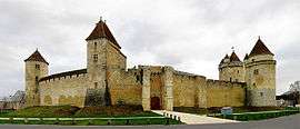 Château de Blandy-les-Tours | |
 Blandy Location within Île-de-France region  Blandy | |
| Coordinates: 48°34′01″N 2°46′58″E / 48.5669°N 2.7828°ECoordinates: 48°34′01″N 2°46′58″E / 48.5669°N 2.7828°E | |
| Country | France |
| Region | Île-de-France |
| Department | Seine-et-Marne |
| Arrondissement | Melun |
| Canton | Nangis |
| Intercommunality | CC Brie des Rivières et Châteaux |
| Government | |
| • Mayor (2008–2014) | Eric Cadiou |
| Area1 | 14.02 km2 (5.41 sq mi) |
| Population (2006)2 | 766 |
| • Density | 55/km2 (140/sq mi) |
| Time zone | UTC+1 (CET) |
| • Summer (DST) | UTC+2 (CEST) |
| INSEE/Postal code | 77034 /77115 |
| Elevation | 59–104 m (194–341 ft) |
|
1 French Land Register data, which excludes lakes, ponds, glaciers > 1 km2 (0.386 sq mi or 247 acres) and river estuaries. 2 Population without double counting: residents of multiple communes (e.g., students and military personnel) only counted once. | |
Blandy (also known as Blandy-les-Tours) is a commune in the Seine-et-Marne department in the Île-de-France region in north-central France.
Demography
The inhabitants are called Blandynois.
Places of interest
- Château de Blandy-les-Tours
- Church of Saint Maurice (14th et 16th centuries)
See also
- Daniel Gittard (1625-1686), architect, born in Blandy-les-Tours
- Communes of the Seine-et-Marne department
References
External links
| Wikimedia Commons has media related to Blandy, Seine-et-Marne. |
- 1999 Land Use, from IAURIF (Institute for Urban Planning and Development of the Paris-Île-de-France région)
- French Ministry of Culture list for Blandy (in French)
- Map of Blandy on Michelin
This article is issued from
Wikipedia.
The text is licensed under Creative Commons - Attribution - Sharealike.
Additional terms may apply for the media files.