Barbizon
| Barbizon | ||
|---|---|---|
| Commune | ||
| ||
 Barbizon Location within Île-de-France region  Barbizon | ||
| Coordinates: 48°26′48″N 2°36′20″E / 48.4467°N 2.6056°ECoordinates: 48°26′48″N 2°36′20″E / 48.4467°N 2.6056°E | ||
| Country | France | |
| Region | Île-de-France | |
| Department | Seine-et-Marne | |
| Arrondissement | Fontainebleau | |
| Canton | Fontainebleau | |
| Intercommunality | CA Pays de Fontainebleau | |
| Government | ||
| • Mayor (2008–2014) | Pierre Bedouelle | |
| Area1 | 5.27 km2 (2.03 sq mi) | |
| Population (2006)2 | 1,588 | |
| • Density | 300/km2 (780/sq mi) | |
| Time zone | UTC+1 (CET) | |
| • Summer (DST) | UTC+2 (CEST) | |
| INSEE/Postal code | 77022 /77630 | |
| Elevation | 75–93 m (246–305 ft) | |
|
1 French Land Register data, which excludes lakes, ponds, glaciers > 1 km2 (0.386 sq mi or 247 acres) and river estuaries. 2 Population without double counting: residents of multiple communes (e.g., students and military personnel) only counted once. | ||
.svg.png)
Barbizon is a commune (town) in the Seine-et-Marne department in north-central France. It is located near the Fontainebleau Forest.
Demographics
The inhabitants are called Barbizonais.
Art history
The Barbizon school of painters is named after the village; Théodore Rousseau and Jean-François Millet, leaders of the school, made their homes and died in the village.
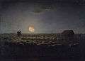 The Sheepfold, Moonlight by Jean-François Millet. The Walters Art Museum.
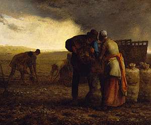
International relations
Twin towns
Friendship cities
See also
References
External links
| Wikimedia Commons has media related to Barbizon. |
- Barbizon website
- 1999 Land Use, from IAURIF (Institute for Urban Planning and Development of the Paris-Île-de-France région) (in English)
- French Ministry of Culture list for Barbizon (in French)
- Map of Barbizon on Michelin (in English)
- Johnson, Clifton (February 3, 1900). "The Village of Jean-François Millet". The Outlook. 64: 275–284. Retrieved 2009-07-30.
| Authority control |
|---|
This article is issued from
Wikipedia.
The text is licensed under Creative Commons - Attribution - Sharealike.
Additional terms may apply for the media files.