La Ferté-Gaucher
| La Ferté-Gaucher | |
|---|---|
| Commune | |
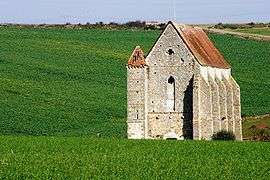 Chapel of the Knights Templar | |
 La Ferté-Gaucher Location within Île-de-France region  La Ferté-Gaucher | |
| Coordinates: 48°47′03″N 3°18′29″E / 48.7842°N 3.308°ECoordinates: 48°47′03″N 3°18′29″E / 48.7842°N 3.308°E | |
| Country | France |
| Region | Île-de-France |
| Department | Seine-et-Marne |
| Arrondissement | Provins |
| Canton | Coulommiers |
| Government | |
| • Mayor (2008–2014) | Yves Jaunaux |
| Area1 | 17.32 km2 (6.69 sq mi) |
| Population (2012)2 | 4,691 |
| • Density | 270/km2 (700/sq mi) |
| Time zone | UTC+1 (CET) |
| • Summer (DST) | UTC+2 (CEST) |
| INSEE/Postal code | 77182 /77320 |
| Elevation | 107–188 m (351–617 ft) |
|
1 French Land Register data, which excludes lakes, ponds, glaciers > 1 km2 (0.386 sq mi or 247 acres) and river estuaries. 2 Population without double counting: residents of multiple communes (e.g., students and military personnel) only counted once. | |
La Ferté-Gaucher is a commune in the Seine-et-Marne department in the Île-de-France region in north-central France.
Demographics
Inhabitants of La Ferté-Gaucher are called Fertois.
See also
References
External links
| Wikimedia Commons has media related to La Ferté-Gaucher. |
- 1999 Land Use, from IAURIF (Institute for Urban Planning and Development of the Paris-Île-de-France région) (in English)
- French Ministry of Culture list for La Ferté-Gaucher (in French)
- Map of La Ferté-Gaucher on Michelin (in English)
This article is issued from
Wikipedia.
The text is licensed under Creative Commons - Attribution - Sharealike.
Additional terms may apply for the media files.