Bidar
| Bidar ಬೀದರ್ | |
|---|---|
| City | |
    (clockwise from top) Bidar Fort; One of the Barid Shahi tombs; Ruins of the Mahmud Gawan Madrasa; Guru Nanak Jhira Sahib | |
| Etymology: Viduranagara (Mahabharata) | |
| Nickname(s): The City of Whispering Monuments | |
 Bidar Location of Bidar in Karnataka | |
| Coordinates (Bidar): 17°54′N 77°30′E / 17.9°N 77.5°E[1] | |
| Country |
|
| State | Karnataka |
| Division | Kalaburagi Division |
| Region | Hyderabad-Karnataka |
| District | Bidar district |
| Taluka | Bidar |
| Named for | Bidri |
| Government | |
| • Type | Municipality |
| • Body | Council |
| Area[2] | |
| • Total | 43 km2 (17 sq mi) |
| Elevation[3] | 710 m (2,330 ft) |
| Population (2011)[2] | |
| • Total | 216,020 |
| • Estimate (2021)[4] | 260,201 |
| • Rank | 216 |
| • Density | 5,000/km2 (13,000/sq mi) |
| • Males | 111,470 |
| • Males density | 2,592/km2 (6,710/sq mi) |
| • Females | 104,550 |
| • Females density | 2,432/km2 (6,300/sq mi) |
| Demonym(s) | "Bidri" |
| Sex Ratio[5] | |
| • per 1000 males | 937 females |
| • in the age, 0-6 | 914 f / 1000 m |
| Literacy Rate[5] | |
| • Average | 87.65% |
| • Male | 92.88% |
| • Female | 82.08% |
| Time zone | UTC+5:30 (IST) |
| PIN | 585 401/02/03 |
| Telephone code | 91-(0)8482-XXXXXX |
| Vehicle registration | KA-38 |
| Official language | Kannada |
| Spoken languages | Kannada , Urdu |
| Website |
www |
Bidar is a hill top city in the north-eastern part of Karnataka state in south India. It is the headquarters of the Bidar which borders Maharashtra and Telangana. It is a rapidly urbanising city in the wider Bidar Metropolitan area. The city is well known for its many sites of architectural, historical and religious importance.
Being located at the farthest of around 700 km (430 mi) from the state capital Bengaluru, it has been neglected by the state government for a long time. However, owing to its rich heritage, the city has a prominent place on the Archaeological Map of India. Picturesquely perched on the Deccan plateau, the Bidar fort is more than 500 years old and still standing strong.[6] According to the book "Bidar Heritage" published by the state Department of Archaeology, Museums and Heritage, of the 61 monuments listed by the department, about 30 are tombs located in and around Bidar city.,[7] explaining its nickname, "City of Whispering Monuments". The heritage sites in and around Bidar have become the major attraction for film shooting in recent years with Bollywood making visits apart from kannada film industry[8]
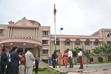
Bidar is home for the second biggest Indian Air Force training centre in the country. The IAF Station Bidar is used for advanced jet training of prospective fighter pilots on BAe Hawk aircraft.[9]
Bidar city is known for its Bidri handicraft products, and its rich history. Bidar is also considered one of the holiest place for Sikh pilgrimage. Unlike other places in the region, Bidar is the coldest and wettest place in north Karnataka. For the year 2009-10, Bidar was ranked 22nd among the cleanest cities in India, and 5th cleanest in Karnataka.[10] SH4 passes through Bidar and the whole city is integrated with 4 lane road.
Ancient Karez System in the city have been recently discovered. The Karez (Qanat) is an underground network of aqueducts for water supply. The Bidar Karez, built in the 15th century, is more than 3 km (1.9 mi) long with 21 air vents.[11] Underground canals, built to connect underground water streams, were meant to provide drinking water to civilian settlements and the garrison inside the Bidar fort. This was necessary in a city where the soil was rocky and drilling wells was difficult.
Toponymy
Bidar is believed to have got its name from Bidri works, .[12]
Legend has associated Bidar with the ancient kingdom of Vidarbha, to which references are found in early Hindu literature like Malavikagnimitra, Mahabharata, the Harivamsa, Bhagavata, and a few other Puranas.[13]:3 Its association can be seen apparently on account of the similarity in names Bidar and Vidarbha. This has been mentioned in Firishta's writings.
The traditional tales reveal that Vidura lived here; hence the place was earlier called Viduranagara and also as the place where Nala and Damayanti (Daughter of Raja Bhima, the King of Vidharba) were meeting.[14]
History
The recorded History of the city goes back to third century B.C. when it was of the great Mauryan Empire. After the Mauryas, Satavahanas, Kadambas and Chalukyas of Badami and later Rashtrakutas reigned over Bidar territory. Chalukyas of Kalyana and Kalachuris of Kalyanis also regained the area. For a short period after Kalyani Chalukyas the area of Bidar was under the sevunas of Devgiri and Kakatiyas of Warangal.
Delhi rulers first headed by Allauddin Khilji and later Muhammed-bin-Tughluq took control of entire Deccan including Bidar. About the middle of the 14th century the Sultan's officers stationed in Deccan rebelled and this resulted in the establishment of Bahamani Dynasty in 1347 A.D. at Gulbarga (present Kalaburagi). There were frequent warfare between the Bahamnis and Vijaynagar Kingdom.[15]
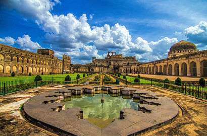
The history of the present fort at Bidar is attributed to the Sultan Ala-ud-Din Bahman Shah the first sultan of the Bahmani dynasty to 1427 when he shifted his capital from Gulbarga to Bidar since it had better climatic conditions and was also a fertile and fruit bearing land. Earliest recorded history of its existence as a small and strong fort is also traced to Prince Ulugh Khan in 1322, whereafter it came under the reign of the Tughlaq dynasty.[16]
With the establishment of the Bahmani dynasty (1347), Bidar was occupied by Sultan Ala-Ud-Din Bahman Shah Bahmani. During the rule of Ahmad Shah I (1422–1486), Bidar was made the capital city of Bahmani Kingdom.[17] The old Fort was rebuilt and beautiful madrasas, mosques, palaces and gardens were raised. Mahmud Gawan who became the Prime Minister in 1466 was a notable figure in the history of Bidar. Bidar remained under the Barid Shahi dynasty until conquest by Bijapur Sultanate in 1619. Aurangzeb came to Bidar after his father, Padshah (emperor) Shah Jahan, appointed him the Prince of Deccan. He wrested the Bidar Fort from the Adil Shahis after a 21-day war in 1656. With this, Bidar became a part of the Mughal dynasty for the second time.[18] Bidar was made a subah (imperial top-level province) in 1656, which Telangana Subah was merged into the next year.
In 1724, Bidar became a part of the Asaf Jahi Kingdom of the Nizams. It was annexed by the Bijapur Sultanate in 1619–20 but the Mughal viceroy of Aurangzeb took it in 1657 and thus became a part the Mughal Empire in 1686.[19] Third son of Asaf jah l ( Nizam l ) Mir Sa'id Muhammad Khan, Salabat Jang ruled from Bidar fort from 1751 to 1762, till his brother Mir Nizam Ali Khan Asaf Jah III imprisoned him in this fort, and was killed in Bidar fort on 16 September 1763. Mohammedabad old name of Bidar is also on his name.
Thus, Bahmanis ruled over Gulbaraga from 1347 to 1424 and from Bidar from 1424 till the extinction of the kingdom and its disintegration into five independent kingdoms of Bijapur, Golconda, Ahmadnagar, Bidar and Berar. After India's independence, in 1956 all Kannada speaking areas were merged to form the Mysore State and Bidar became part of the new Mysore (now Karnataka) state.[19][20][21]
Geography
Bidar is located at 17°54′N 77°30′E / 17.9°N 77.5°E,[22] lies at a central position in Deccan, a plateau at an elevation of 2300 ft from the sea level. It has common boundaries with Maharashtra and Telangana which is, with the districts of Nizamabad and Medak in Telangana on the East and the districts of Nanded and Osmanabad in Maharashtra on the west. On the south lies the district Gulbarga of Karnataka.
Geology

The upper crust of the plateau is of laterite, a soft porous rock with limonitic surface. This crust varies in depth from 100 ft (30 m) to 500 ft (150 m) and rests on a bed of trap, which is of much harder texture and less pervious to water. The volume of water filtered during the monsoons through the laterite stratum is arrested by the trappean bed, and a nursery of springs is formed whose natural level of effluence is the line of contact of the two strata along the base of the cliffs of the plateau. The water in course of time frets out for itself an orifice and macerates and loosens portions of its rocky channel till a rift is produced. The rift gradually dilates into a ravine, and the ravine expands into a vale.
The Karez System is built along a geological fracture. Such fractures are formed at the intersection of laterite and basalt rocks and form lineaments or springs that yield water.[23]
Soil
Bidar soils are deep (>100 cm), well-drained gravelly red clayey soils developed on plateaus of laterites. They are slightly acid to neutral (pH 6.6) in reaction with low cation exchange capacity. They are highly gravelly soils with gravel content (60 to 10%) that decrease with depth.[24]
Climate
The winter season is from November to middle of February. Bidar is one of the coldest cities (by southern standards) in Karnataka as the minimum temperature during winter nights regularly hovers around 11-12 during December, which is the coldest month with mean daily maximum temperature of 27.3 C and mean daily minimum of 13.4 C. From the middle of the February, both day and night temperatures begin to rise rapidly. May is the hottest month with mean daily maximum temperature of 38.8 C and mean daily minimum of 25.9 C. With the withdrawal of southwest monsoon in the first week of October, there is slight increase in day temperature but night temperature decreases steadily. After October, both day and night temperatures decreases progressively. The highest maximum temperature recorded at Bidar was on 8-5-1931(43.3 degree C) and the lowest minimum was on 5-1-1901(2.9 degree C, the lowest temperature ever recorded in Karnataka).[25]
Present day Bidar covers an expanse of 5448 square kilometres of land and lies between 17°35′ and 18°25′ North latitudes and 76°42′ and 77°39′ east longitudes.
| Climate data for Bidar | |||||||||||||
|---|---|---|---|---|---|---|---|---|---|---|---|---|---|
| Month | Jan | Feb | Mar | Apr | May | Jun | Jul | Aug | Sep | Oct | Nov | Dec | Year |
| Average high °C (°F) | 28.6 (83.5) |
31.8 (89.2) |
34.6 (94.3) |
36.4 (97.5) |
37.5 (99.5) |
33.4 (92.1) |
30.5 (86.9) |
29.0 (84.2) |
30.1 (86.2) |
29.0 (84.2) |
27.7 (81.9) |
27.4 (81.3) |
31.3 (88.4) |
| Average low °C (°F) | 14.0 (57.2) |
15.9 (60.6) |
18.9 (66) |
23.0 (73.4) |
25.5 (77.9) |
23.9 (75) |
22.0 (71.6) |
21.2 (70.2) |
21.5 (70.7) |
19.0 (66.2) |
16.9 (62.4) |
12.9 (55.2) |
19.6 (67.2) |
| Average rainfall mm (inches) | 12.6 (0.496) |
17.1 (0.673) |
23.0 (0.906) |
22.0 (0.866) |
42.2 (1.661) |
114.1 (4.492) |
180.1 (7.091) |
245.5 (9.665) |
136.0 (5.354) |
102.6 (4.039) |
39.2 (1.543) |
3.5 (0.138) |
937.9 (36.924) |
Economy
Once a home to many cottage industries, such as cotton and oil-ginning mills,[26] there are now few industries that draw on local raw materials or skills. Even the well known form of local articrafts, bidri ware, is in a state of decline. Increasing prices of materials, especially silver, and declining sales have meant that many of the hereditary artisans are no longer employed in the production of such ware.[27] Bidar city is famous for a large industrial area i.e. kolhar industrial area in which one of most successful US FDA approved company i.e. Sai Life Sciences and so many successful pharma companies like vivimed, corvine pharma, shreegen pharma, santho carrels pharma,shreevan chemicals and so on.
one of most famous product of RSPL Group Uttar Pradesh i.e. Ghadi Detergents Powder and cake 's Unit factory is also located at bidar city.
Tourism

Bidar is symbolically described as City of Whispering Monuments.[28] The mountaintop city that served as the capital of medieval Deccan, has 98 monuments of which four national monuments are protected by the Archaeological Survey of India and 14 by the State Archaeology Department, Karnataka.
Bidar earned a place on the World Monument Watchlist 2014.[29] Of the 741 proposals received from 166 countries, 67 sites from 41 countries were finally selected which were announced by WMF president Bonnie Burnham in New York on October 8, 2013.[30] Along with "the historic city of Bidar", two other sites in India to figure in the list were the house of Sheikh Salim Chisti in Fatehpur Sikri and Juna Mahal in Rajasthan.
The WMF in its current watch site for "the historic city of Bidar" says ″challenges to the site include a lack of integrated conservation and maintenance, environmental pollution, and the construction of new developments and roadways that encroach on the historic fabric. Current land use regulations also threaten the economic livelihood of many of the city's residents, and it is hoped that revised, context-specific planning policies would both protect Bidar's historic assets while also supporting the future of its local population. It is hoped that Watch-listing will spur documentation and analysis of the city's conditions, followed by policy development and applied conservation interventions that will reveal and maintain Bidar's rich heritage, as well as support a robust and sustainable tourist industry.″[31]
Mahmud Gawan Madrasa
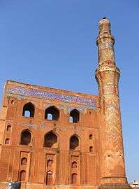
This grandiose madrasa was built by the prime-minister of the Bahmani empire, Mahmud Gawan in the late 15th century. Its only the most imposing building of the Bahmani period, but in its plan and in the general style of its architecture it is a unique monument of its kind in India. The Madrasa, a multi-disciplinary university he set up, which had a library of around 3,000 valuable manuscripts, was severely damaged when gunpowder stored inside the rooms went off during a 27-day siege of the city by Mughal king Aurangazeb in 1656. The Mahmud Gawan Madrasa is protected by the Archaeological Survey of India.
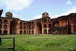
Bidar Fort[32] is considered one of the most formidable forts of the country. Bidar city was distinctly planned and built. The main citadel complex housed the royal places. Mahals and Mosque. Adjoining to this on the southern side, the city was built for the people. Both the citadel complex and city had separate forts for protection the plan of the Bidar city fortification is pentagonal. There are five gateways for entry into the city fort. It is main citadel complex fort which is stronger. It is built on the brink of the plateau. Engineers and architecture of various countries were employed on its design and construction. A Museum is preset there having old armor, old sculptures. including many of the ancient stones,[33]
- Rangeen Mahal, situated in the fort, near Gumbad Darwaza, is unique because of its decoration with coloured tiles and other art work. Wood carving done there is not only precious but also unique. The walls of Mahal are adorned with mother-of-pearl of the finest quality in laid in jet-black stone. Floral patterns and calligraphic text are also depicted here. Stone carving, stucco art are other attractions of this monument. It was rebuilt during Barid Shahi period.
The design of this monument represents the blend of the both Hindu and Muslim architecture. There are rooms in the basement of the Rangin Mahal.[34]
- Tarkash Mahal is said to have been built for Turkish wife of the sultan. From the remains of the decorative work found in the ornamentation of the walls, it can be said that the Mahal was built or extended by the Barid Shahi Sultans who had kept large harem with ladies from different nationalities.The rooms were decorated with stucco work.[35]
- Gagan Mahal was originally built by the Bahamani kings and some alterations and additions were made by the Barid Shahi rulers. It has two courts. The outer court was used by the male staff and guards. The inner court also, there are rooms on either side of the covered passage for the accommodation of the guards. The main building of the palace was for the use of the sultan and his harem.[36]
- Takht Mahal, The Royal Palace, was built by Ahemd shah. It was the royal residence. The place was fully decorated with coloured titles and stone carvings part of which can be seen even today. It had two side royal pavilions with lofty arches and a spacious hall at the back of which was the sultan's room.
The building had stately dimensions and exquisite surface decoration. The coronations of several Bahamanis and Barid Shahi sultans were held there. From the royal pavilion which is situated behind throne palace one can view the valley and low land below.
- Chaubara is a tall tower, facing in four directions. This is an old cylindrical tower of 22 meters, height is situated in the centre of Bidar city. It was used as a watchtower, commanding a fine view of the entire plateau from the top. A winding staircase of eight steps leads to the top of the tower, a clock is being placed on top of the tower, can be viewed from all the four directions .[37]
- Solah Khamba Mosque (Solah Sutoon Ki Masjid) was built by Qubil Sultani between 1423 and 1424. The mosque derives its name from the 16 pillars that are lined in the front of the structure. Popularly known as the Zanana Masjid, this mosque is about 90 metres long and 24 metres wide. Behind the southern wall of this mosque, there is a large well. Characterised by columns, arches and domes, this mosque is one of the largest in India.[38]
- Jama Masjid, a large mosque with no minarets, located near Chaubara.
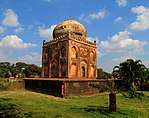
- Bahmani Tombs called as "Ashtur", located near "Chaukhandi of Hazrat Khalil Ullah" around a distance of 1 km
- Barid Shahi Tombs
- Chaukhandi of Hazrat Khalil Ullah
Religious places
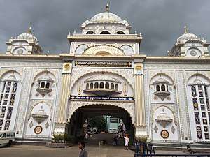
Gurudwara Nanak Jhira Sahib
Gurudwara Nanak Jhira Saheb is known to be one of Holiest Place For Sikh Devotees in India and is believed that Saint Guru Nanak visited the place during famine in this region.[40] Papa Nashini Mandir Dargah Hazrat Shah Shamsuddin Quadri (Multani Basha) Dargah Hazrat Syed Abul Faiz Mailar Mallana Mandir Narasimha Jharni Mandir Changleri Veerabhadra Mandir
Art

Bidri wares
Bidriware, one of the rarest and most intricate art forms is now unique to the city.[41] This native art form has obtained Geographical Indications (GI) registry.[42] The various art forms created by artists from Bidar city centuries ago are now major attractions in museums such as Victoria and Albert Museum, London, the National Museum in New Delhi and Indian Museum in Kolkata.[41]
The Karnataka tableau at the 2011 Republic Day Parade at Rajpath in New Delhi featured Bidriware and Bidri artisans from Bidar.
Rehaman Patel did an extensive research in Bidri Art from Gulbarga University. His book in Kannada version (2012) and English version (2017) also published on Bidri Art.
All the dignitaries & guests of XIX Commonwealth Games 2010 were presented with mementos hand crafted in Bidri art. This art form is the Union government's choice for souvenirs at the World Economic Forum in Davos. The Kingfisher company owner Vijay Mallya has a bidri dining table with floral designs made of nearly 3.5 kg silver.[43]
Transport
Rail
Bidar has connectivity with Bangalore, Hyderabad, Sainagar Shirdi, Parbhani Jn, Aurangabad, Latur, Nanded, Manmad, Mumbai, Machilipatnam and Renigunta (according to railway budget 2014-15) Construction of the Gulbarga-Bidar link is completed which was inaugurated by Prime Minister Narendra Modi.[44][45] Bidar-Hyderabad inter-city train service became operative in September 2012.[46] A Bidar-Yeshwantpur (Daily) express train[47] and Bidar-LTT Mumbai express train[48] service has been started recently. another train starting from bidar through Latur to Mumbai started, which runs on Thursday,Saturday and Sunday the train which stars from auranagav
Air
The city is home to an air force station. There is no civilian airfield; however, The Hindu reported in February 2017 that the opening of the air force base to passenger flights was likely under the central government's Ude Desh ka Aam Naagrik plan.[49]
Education Institutions

Bidar city is very far about education sector shaheen group of institutions is one of the big group of institutions in bidar city and one more group is coming far in bidar city about education field the Royal group of education providing quality education.Beside these another education institution that is famous and widely recognised in Bidar is Kendriya Vidyalaya Bidar which was founded in 1975 and still excelling in every field.
- Mahmud Gawan Madarsa (The ancient university)
- Future Kids School
- Karnataka Veterinary Animal and Fisheries Sciences University[50]
- Bidar Institute Of Medical Sciences (BRIMS)[51]
- SB Patil Dental College & Hospital[52]
- Shanthinikethan Instt. Of Physiotherapy
- Guru Nank Dev College Of Engineering Bidar[53]
- Lingraj Appa Engineering college, Chitta Bidar[54]
- Karnatak Arts, Science and Commerce College, Bidar[55]
- Akkamahadevi Mahila Mahavidyalaya for women's
- Royal degree college bidar
- Red rose public school
- Everest degree college mailoor road bidar.
- B. V. Bhoomareddi College of Arts, Science & Commerce, Gumpa Road Bidar[56]
- Shree Swaminarayan Gurukul International School[57]
- The Millennium Public School Bidar[58]
- Shaheen public schools and colleges Bidar[59]
- Shaheen Degree college for women
- Noor Educational Trust, Bidar[60]
- Air Force school, Bidar[61]
- Kendriya Vidyalaya, Bidar
- seventh day Adventist high school Bidar
- seventh day Adventist higher - primary school bhalki
Galleries
.jpg)
.jpg)

 Madrasa Bidar Bidar
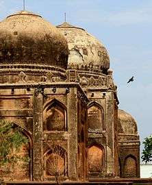 Ashtur Tombs
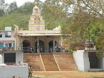 Papnash Temple
.jpg) Bidar - Cement murals on main roads
Bidar - Cement murals on main roads
References
- ↑ co-ordinates represent the city limits broadly
- 1 2 "City/Town Summary". Bidar City Municipal Council, ಬೀದರ ನಗರಸಭೆ. Retrieved 11 March 2015.
- ↑ Elevation of the CITY is not to be confused with that of TALUKA, which averages to 664m (2178ft)
- ↑ Directorate of Economics and Statistics, B'luru, 2013
- 1 2 "Bidar City Census 2011 data". census2011.co.in. Retrieved 14 March 2015.
- ↑ "Bidar fort stands the test of time". Deccan Herald. 4 January 2010. Retrieved 5 March 2015.
- ↑ "Bidar has 30 tombs of former kings". The Hindu. 6 August 2008. Retrieved 5 March 2015.
- ↑ "Holding fort at Bidar". The Hindu. 16 September 2011. Retrieved 5 March 2015.
- ↑ "Two Hawks will land in Bidar on November 12". The Hindu. 11 November 2007. Retrieved 5 March 2015.
- ↑ "India's cleanest: Where does your city stand?". News.rediff.com. 2010-05-13. Retrieved 2013-12-19.
- ↑ "Picnic spot of Barid Shahi kings discovered in Bidar". The Hindu. 17 December 2012. Retrieved 5 March 2015.
- ↑ "Deccan dreams". Business Line. 23 September 2005. Retrieved 16 March 2015.
- ↑ Ghulam Yazdani (10 June 1944). Bidar - Its History and Monuments. Oxford University Press, London.
|access-date=requires|url=(help) - ↑ Karnataka Gazetteer (Second ed.). Govt. of Karnataka. 1 January 1983.
|access-date=requires|url=(help) - ↑ http://www.bidartourism.com/history.html
- ↑ http://kannadasiri.kar.nic.in/heritage/heritage_areas.htm
- ↑ Sen, Sailendra (2013). A Textbook of Medieval Indian History. Primus Books. pp. 106–108. ISBN 978-9-38060-734-4.
- ↑ "An occasion to recall Aurangazeb's association with this historic city". The Hindu. Retrieved 5 March 2015.
- 1 2 "Geography and travel". Encyclopædia Britannica. Archived from the original on 4 December 2009. Retrieved 2009-11-08.
- ↑ Sherwani, Haroon Khan (1969). Cultural trends in medieval India: architecture, painting, literature & language. Asia Pub. House. pp. 14–16. Retrieved 2009-11-07.
- ↑ "Gulbarga Fort". British Library On Line gallery. Retrieved 2009-11-07.
- ↑ "Falling Rain Genomics, Inc – Bidar". Fallingrain.com. Retrieved 2013-12-19.
- ↑ "A thrilling walk through medieval waterways". The Hindu. 2 November 2014. Retrieved 6 March 2015.
- ↑ Characterisation of sugarcane soils of Karnataka L.C.K. Naidu, National Bureau of Soil Survey and Land Use Planning. Regional Centre. Hebbal. Bangalore 560024.
- ↑ "Bidar District Website". Bidar.nic.in. 2013-10-21. Retrieved 2013-12-19.
- ↑ Bidar District Gazetteer, Govt. Printing Press, Bangalore, 1977.
- ↑ Agrarian Distress in Bidar, A report by NATIONAL INSTITUTE OF ADVANCED STUDIES, 1999
- ↑ "Bidar Utsav from February 18" (Bidar [HY-GB]). Kasturi & Sons Ltd. 'The Hindu'. 6 February 2011.
- ↑ "Urgent need to promote tourism in Bidar" (Bidar [HY-GB]). Kasturi & Sons Ltd. The Hindu. 21 January 2015.
- ↑ "Bidar only South Indian monument to figure in latest World Monuments Fund list" (Bidar [HY-GB]). Kasturi Sons & Ltd. The Hindu. 10 October 2013.
- ↑ "Historic City of Bidar". World Monuments Fund.
- ↑ Bidar Fort
- ↑ http://www.bidartourism.com/fort.html
- ↑ http://www.bidartourism.com/rangeenMahal.html
- ↑ http://www.bidartourism.com/TarkashMahal.html
- ↑ http://www.bidartourism.com/GaganMahal.html
- ↑ http://www.bidartourism.com/Chaubara.html
- ↑ http://www.holidayiq.com/Solah-Khamba-Mosque-Bidar-Sightseeing-649-757.html
- ↑ http://www.census2011.co.in/data/religion/district/246-bidar.html
- ↑ http://www.hoparoundindia.com/karnataka/bidar-attractions/gurudwara-nanak-jhira-saheb.aspx
- 1 2 "Tracing the history of Bidriware". The Hindu. 24 January 2012. Retrieved 5 March 2015.
- ↑ "Innovative designs help revive Bidriware". The Hindu. 26 March 2008. Retrieved 6 March 2015.
- ↑ "A Bidri dining table for the Mallya family". The Hindu. 16 February 2013. Retrieved 6 March 2015.
- ↑ "PM Modi to inaugurate Bidar-Kalaburgi railway line".
- ↑ "Bidar-Gulbarga rail service". Infrastructure Today, January 2012. Retrieved 21 December 2013.
- ↑ http://ibnlive.in.com/news/hyderabadbidar-intercity-train/289863-60.html
- ↑ "Frequency of Bidar-Y'pur Train to be Increased". The New Indian Express. 23 December 2014.
- ↑ "First Bidar-Mumbai train to be flagged off today". Kasturi & Sons Ltd. 10 February 2015. Retrieved 10 February 2015.
- ↑ Desai, Rishikesh Bahadur (20 February 2017). "Bidar airport likely to be opened under UDAN". The Hindu. Retrieved 24 July 2017.
- ↑ http://www.kvafsu.kar.nic.in/
- ↑ "brims-bidar.in". brims-bidar.in. Retrieved 2013-12-19.
- ↑ http://sbpatildentalcollege.com/
- ↑ http://www.gndecbidar.in/
- ↑ http://www.lingarajappaec.ac.in/
- ↑ http://www.minglebox.com/college/k-r-e-society-s-karnatak-arts-science-and-commerce-college-bidar
- ↑ http://hkesociety.org/bvb/
- ↑ "Shree Swaminarayan Gurukul International School". Gurukul.org. Retrieved 2013-12-19.
- ↑ http://www.tmpsbidar.com/
- ↑ http://www.shaheenpucollege.com/
- ↑ http://www.nooreducationaltrust.co.in/
- ↑ http://www.afschoolbidar.edu.in/
![]()
External links
| Wikimedia Commons has media related to Bidar. |
| Wikivoyage has a travel guide for Bidar. |