Clarksfield Township, Huron County, Ohio
| Clarksfield Township, Huron County, Ohio | |
|---|---|
| Township | |
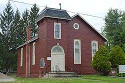 Township hall at Clarksfield | |
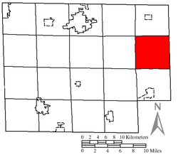 Location of Clarksfield Township in Huron County | |
| Coordinates: 41°10′49″N 82°24′8″W / 41.18028°N 82.40222°WCoordinates: 41°10′49″N 82°24′8″W / 41.18028°N 82.40222°W | |
| Country | United States |
| State | Ohio |
| County | Huron |
| Area | |
| • Total | 26.5 sq mi (68.7 km2) |
| • Land | 26.4 sq mi (68.4 km2) |
| • Water | 0.1 sq mi (0.3 km2) |
| Elevation[1] | 922 ft (281 m) |
| Population (2010) | |
| • Total | 1,625 |
| • Density | 62/sq mi (23.8/km2) |
| Time zone | UTC-5 (Eastern (EST)) |
| • Summer (DST) | UTC-4 (EDT) |
| ZIP code | 44889 |
| Area code(s) | 440 |
| FIPS code | 39-15364[2] |
| GNIS feature ID | 1086343[1] |
Clarksfield Township is one of the nineteen townships of Huron County, Ohio, United States. As of the 2010 census the population of the township was 1,625.[3]
Geography
Located on the eastern edge of the county, it borders the following townships:
- Wakeman Township - north
- Camden Township, Lorain County - northeast
- Brighton Township, Lorain County - east
- Rochester Township, Lorain County - southeast corner
- New London Township - south
- Fitchville Township - southwest corner
- Hartland Township - west
- Townsend Township - northwest corner
No municipalities are located in Clarksfield Township, although the unincorporated community of Clarksfield lies in the township's northwest.
Name and history
Clarksfield Township was named for James Clark, a hero of the Revolutionary War.[4]
It is the only Clarksfield Township statewide.[5]
Government
The township is governed by a three-member board of trustees, who are elected in November of odd-numbered years to a four-year term beginning on the following January 1. Two are elected in the year after the presidential election and one is elected in the year before it. There is also an elected township fiscal officer,[6] who serves a four-year term beginning on April 1 of the year after the election, which is held in November of the year before the presidential election. Vacancies in the fiscal officership or on the board of trustees are filled by the remaining trustees.
References
- 1 2 "US Board on Geographic Names". United States Geological Survey. 2007-10-25. Retrieved 2008-01-31.
- ↑ "American FactFinder". United States Census Bureau. Archived from the original on 2013-09-11. Retrieved 2008-01-31.
- ↑ "Geographic Identifiers: 2010 Census Summary File 1 (G001): Clarksfield township, Huron County, Ohio". American Factfinder. U.S. Census Bureau. Retrieved January 11, 2018.
- ↑ Baughman, Abraham J. (1909). History of Huron County, Ohio: Its Progress and Development, with Biographical Sketches of Prominent Citizens of the County, Volume 1. S. J. Clarke Publishing Company. p. 198.
- ↑ "Detailed map of Ohio" (PDF). United States Census Bureau. 2000. Retrieved 2007-02-16.
- ↑ §503.24, §505.01, and §507.01 of the Ohio Revised Code. Accessed 4/30/2009.
External links
Municipalities and communities of Huron County, Ohio, United States | ||
|---|---|---|
| Cities | 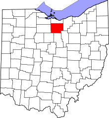 | |
| Villages | ||
| Townships | ||
| CDPs | ||
| Unincorporated communities | ||
| Footnotes | ‡This populated place also has portions in an adjacent county or counties | |