Sylvania, Ohio
| Sylvania, Ohio | ||
|---|---|---|
| City | ||
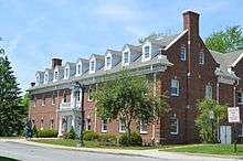 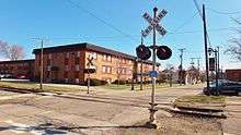 Top: Sylvania City Hall Bottom: Railroad crossing in downtown Sylvania. | ||
| ||
| Nickname(s): Tree City USA | ||
| Motto(s): "Serving the Community" | ||
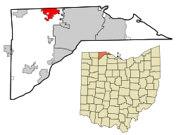 Location in Lucas County and the state of Ohio. | ||
| Coordinates: 41°42′41″N 83°42′12″W / 41.71139°N 83.70333°WCoordinates: 41°42′41″N 83°42′12″W / 41.71139°N 83.70333°W | ||
| Country | United States | |
| State | Ohio | |
| County | Lucas | |
| Government | ||
| • Mayor | Craig A. Stough (R)[1] | |
| Area[2] | ||
| • Total | 6.53 sq mi (16.91 km2) | |
| • Land | 6.48 sq mi (16.78 km2) | |
| • Water | 0.05 sq mi (0.13 km2) | |
| Elevation[3] | 663 ft (202 m) | |
| Population (2010)[4] | ||
| • Total | 18,971 | |
| • Estimate (2015[5]) | 18,965 | |
| • Density | 2,926.7/sq mi (1,130.0/km2) | |
| Time zone | UTC-5 (Eastern (EST)) | |
| • Summer (DST) | UTC-4 (EDT) | |
| ZIP code | 43560 | |
| Area code(s) | 419 | |
| FIPS code | 39-76022[6] | |
| GNIS feature ID | 1061668[3] | |
| Website | http://www.cityofsylvania.com/ | |

Sylvania is a city in Lucas County, Ohio, United States. The population was 18,971 at the 2010 census. Sylvania is a suburb of Toledo. Its northern border is the southern border of the State of Michigan.[7]
History
Sylvania was platted in 1836.[8] A post office called Sylvania has been in operation since 1859.[9] Sylvania was incorporated in 1867.[10]
Geography
Sylvania is located at 41°42′41″N 83°42′12″W / 41.71139°N 83.70333°W (41.711450, -83.703210).[11]
According to the United States Census Bureau, the city has a total area of 6.53 square miles (16.91 km2), of which, 6.48 square miles (16.78 km2) is land and 0.05 square miles (0.13 km2) is water.[2]
Sylvania is approximately 10 miles west-northwest of Toledo, Ohio.
Demographics
| Historical population | |||
|---|---|---|---|
| Census | Pop. | %± | |
| 1880 | 523 | — | |
| 1890 | 545 | 4.2% | |
| 1900 | 617 | 13.2% | |
| 1910 | 1,002 | 62.4% | |
| 1920 | 1,222 | 22.0% | |
| 1930 | 2,108 | 72.5% | |
| 1940 | 2,199 | 4.3% | |
| 1950 | 2,433 | 10.6% | |
| 1960 | 5,187 | 113.2% | |
| 1970 | 12,031 | 131.9% | |
| 1980 | 15,556 | 29.3% | |
| 1990 | 17,301 | 11.2% | |
| 2000 | 18,670 | 7.9% | |
| 2010 | 18,971 | 1.6% | |
| Est. 2017 | 18,941 | [12] | −0.2% |
| Sources:[6][13][14][15][16][17][18] | |||
2010 census
As of the census[4] of 2010, there were 18,971 people, 7,642 households, and 5,092 families residing in the city. The population density was 2,926.7 inhabitants per square mile (1,130.0/km2). There were 8,165 housing units at an average density of 1,260.0 per square mile (486.5/km2). The racial makeup of the city was 92.4% White, 2.7% African American, 0.1% Native American, 2.3% Asian, 0.1% Pacific Islander, 0.7% from other races, and 1.7% from two or more races. Hispanic or Latino of any race were 2.9% of the population.
There were 7,642 households of which 31.3% had children under the age of 18 living with them, 53.0% were married couples living together, 10.1% had a female householder with no husband present, 3.5% had a male householder with no wife present, and 33.4% were non-families. 28.7% of all households were made up of individuals and 12.8% had someone living alone who was 65 years of age or older. The average household size was 2.43 and the average family size was 3.02.
The median age in the city was 42.7 years. 23.6% of residents were under the age of 18; 7.8% were between the ages of 18 and 24; 21.5% were from 25 to 44; 29.9% were from 45 to 64; and 17.2% were 65 years of age or older. The gender makeup of the city was 47.3% male and 52.7% female.
2000 census
| Largest ancestries (2000) | Percent |
|---|---|
| German | 32.8% |
| Irish | 15.7% |
| Polish | 10.7% |
| Italian | 6.2% |
| American | 4.9% |
As of the census[6] of 2000, there were 18,670 people, 7,151 households, and 5,070 families residing in the city. The population density was 3,223.2 people per square mile (1,245.0/km²). There were 7,392 housing units at an average density of 1,276.2 per square mile (492.9/km²). The racial makeup of the city was 95.20% White, 1.00% African American, 0.10% Native American, 2.10% Asian, 0.01% Pacific Islander, 0.64% from other races, and 0.96% from two or more races. Hispanic or Latino of any race were 1.63% of the population. The city has a significant Jewish community.
There were 7,151 households out of which 37.2% had children under the age of 18 living with them, 59.8% were married couples living together, 8.7% had a female householder with no husband present, and 29.1% were non-families. 25.7% of all households were made up of individuals and 11.2% had someone living alone who was 65 years of age or older. The average household size was 2.59 and the average family size was 3.16.
In the city, the population was spread out with 28.2% under the age of 18, 6.7% from 18 to 24, 26.7% from 25 to 44, 25.0% from 45 to 64, and 13.3% who were 65 years of age or older. The median age was 38 years. For every 100 females, there were 90.7 males. For every 100 females age 18 and over, there were 86.6 males.
The median income for a household in the city was $57,358, and the median income for a family was $73,947. Males had a median income of $52,892 versus $34,583 for females. The per capita income for the city was $28,163. About 3.7% of families and 4.2% of the population were below the poverty line, including 4.2% of those under age 18 and 3.9% of those age 65 or over.
Government
The mayor of Sylvania is Craig Stough. Sylvania has a city council made up of seven members. The president of Sylvania City Council is Mary Westphal. The remaining members of council are, Katie Cappellini, Mark Frye, Doug Haynam, Sandy Husman, Mark Luetke, and Jason Mishka.[19][20]
Education
Sylvania has two public libraries, one near each high school, which are branches of the Toledo-Lucas County Public Library.[21]
Public
Public schools in Sylvania, Ohio are all part of the Sylvania Schools System. The superintendent of schools is Adam Fineske.
- Elementary schools
- Highland Elementary School
- Hill View Elementary School
- Maplewood Elementary School
- Stranahan Elementary School
- Sylvan Elementary School
- Whiteford Elementary School
- Central Trail Elementary School
- Junior high schools
- Arbor Hills Junior High School
- McCord Junior High School
- Timberstone Junior High School
- High schools
Private
- Toledo Islamic Academy
- Little Miracles Montessori School
- St. Joseph Elementary & Junior High School
Colleges
Parks and recreation
The city is home to several parks, including Olander Park, Pacesetter Park, Veterans Memorial, and Burnham Park. Olander Park has a large 28 acre pond as well as other satellite parks (Fossil Park, Sylvan Prairie Park, Whetstone Park and Southview Oak Savanna), Pacesetter Park has lacrosse, soccer, and baseball fields, and Burnham Park contains Plummer Pool.
Most of Sylvania's recreational activities take place thorough the Sylvania Department of Recreation (Sylvania Rec.) They have a building with 2 ice skating rinks and 2 indoor soccer fields. The rec offer sports such as; soccer, baseball, lacrosse, Ice Hockey, and Ice skating. The Rec. partners with Pacesetter Park to play sports. Also the baseball fields at Veterans Memorial Park are utilized by the Rec.
Sylvania Country Club offers competitive swimming for children 18 and under.
Sylvania Tsunamis are also a competitive 18 and under swim team that practices out of the Sylvania Northview Highschool pool.
Sister city
Sylvania is the sister city of Woodstock, Ontario, Canada.[22]
Notable people
- Sam Abell - photographer
- Mark Berger - economist
- Terry Cook - automobile racing driver
- Alissa Czisny - two-time U.S. champion figure skater
- Chip Davis - musician
- Jon Diebler - basketball player
Notable event
- Marathon Classic, an LPGA Tour event that has been played in Sylvania since 1989.
References
- ↑ "Office Holder Details". Lucas County Board of Elections. 31 December 2015. p. 19. Retrieved 1 February 2016.
- 1 2 "US Gazetteer files 2010". United States Census Bureau. Archived from the original on 2012-01-24. Retrieved 2013-01-06.
- 1 2 "US Board on Geographic Names". United States Geological Survey. 2007-10-25. Retrieved 2008-01-31.
- 1 2 "American FactFinder". United States Census Bureau. Retrieved 2013-01-06.
- ↑ "Population Estimates". United States Census Bureau. Retrieved 2016-06-07.
- 1 2 3 "American FactFinder". United States Census Bureau. Retrieved 2008-01-31.
- ↑ Mangus, Michael; Herman, Jennifer L. (2008). Ohio Encyclopedia. North American Book Dist LLC. p. 542. ISBN 978-1-878592-68-2.
- ↑ Scribner, Harvey (1910). Memoirs of Lucas County and the City of Toledo: From the Earliest Historical Times Down to the Present, Including a Genealogical and Biographical Record of Representative Families. Western Historical Association. p. 185.
- ↑ "Lucas County". Jim Forte Postal History. Retrieved 21 January 2016.
- ↑ Waggoner, Clark (1888). History of the City of Toledo and Lucas County, Ohio. Munsell & Company. p. 892.
- ↑ "US Gazetteer files: 2010, 2000, and 1990". United States Census Bureau. 2011-02-12. Retrieved 2011-04-23.
- ↑ "Population and Housing Unit Estimates". Retrieved May 26, 2018.
- ↑ "Population of Civil Divisions Less than Counties" (PDF). Statistics of the Population of the United States at the Tenth Census. U.S. Census Bureau. Retrieved 28 November 2013.
- ↑ "Population: Ohio" (PDF). 1910 U.S. Census. U.S. Census Bureau. Retrieved 28 November 2013.
- ↑ "Population: Ohio" (PDF). 1930 US Census. U.S. Census Bureau. Retrieved 28 November 2013.
- ↑ "Number of Inhabitants: Ohio" (PDF). 18th Census of the United States. U.S. Census Bureau. Retrieved 22 November 2013.
- ↑ "Ohio: Population and Housing Unit Counts" (PDF). U.S. Census Bureau. Retrieved 22 November 2013.
- ↑ "Incorporated Places and Minor Civil Divisions Datasets: Subcounty Population Estimates: April 1, 2010 to July 1, 2012". U.S. Census Bureau. Archived from the original on 17 June 2013. Retrieved 25 November 2013.
- ↑ "Archived copy". Archived from the original on 2015-06-11. Retrieved 2015-06-11.
- ↑ http://www.ourtownsylvania.com/Our-Town-News/2014/12/16/Jason-Mishka-appointed-to-City-Council.html
- ↑ "Hours & Locations". Toledo-Lucas County Public Library. Retrieved 26 February 2018.
- ↑ "Sister City Garden". Sylvania Historical Village. Retrieved 11 April 2015.
External links
Municipalities and communities of Lucas County, Ohio, United States | ||
|---|---|---|
| Cities |  | |
| Villages | ||
| Townships | ||
| CDPs | ||
| Unincorporated communities |
| |
| Ghost towns | ||
| Footnotes | ‡This populated place also has portions in an adjacent county or counties | |