Bassemberg
| Bassemberg | ||
|---|---|---|
| Commune | ||
 | ||
| ||
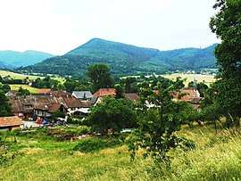
 Bassemberg Location within Grand Est region  Bassemberg | ||
| Coordinates: 48°20′07″N 7°17′03″E / 48.3353°N 7.2842°ECoordinates: 48°20′07″N 7°17′03″E / 48.3353°N 7.2842°E | ||
| Country | France | |
| Region | Grand Est | |
| Department | Bas-Rhin | |
| Arrondissement | Sélestat-Erstein | |
| Canton | Mutzig | |
| Intercommunality | Canton de Villé | |
| Government | ||
| • Mayor (2014–2020) | Emmanuel Eschrich | |
| Area1 | 1.78 km2 (0.69 sq mi) | |
| Population (2010)2 | 265 | |
| • Density | 150/km2 (390/sq mi) | |
| Time zone | UTC+1 (CET) | |
| • Summer (DST) | UTC+2 (CEST) | |
| INSEE/Postal code | 67022 /67220 | |
| Elevation | 275–616 m (902–2,021 ft) | |
|
1 French Land Register data, which excludes lakes, ponds, glaciers > 1 km2 (0.386 sq mi or 247 acres) and river estuaries. 2 Population without double counting: residents of multiple communes (e.g., students and military personnel) only counted once. | ||
Bassemberg (German: Bassenberg) is a French commune in the Bas-Rhin department in the Alsace region of north-eastern France.[1]
The inhabitants of the commune are known as Bassembergeois or Bassembergeoises.[2]
The commune has been awarded one flower by the National Council of Towns and Villages in Bloom in the Competition of cities and villages in Bloom.[3]
Geography

Bassemberg is located 1 km south-west of Villé and 12 km north-west of Sélestat.[4][5] The commune covers 178 hectares and is divided into two distinct areas separated by the valley of Giessen:
- On the north side is the southern slope of the Honel with an altitude of 475 m at Scheibenberg and 615 metres further west. Its steep slopes are covered with old cultivated forests.
- On the south-west side the commune encroaches slightly on the right bank of the Giessen towards Comte-Ban (Eichmatt farm sector). Regular and a few steep slopes rise from 280 to 330 metres above sea level and are suitable for agriculture.
The village is 280 metres above sea level at the foot of the slope of the Honel. Its location close to Giessen does not protect it from flooding of the river.
Access to the commune is by the D39 road from Villé]] in the north-east which passes through the commune and continues to Fouchy. The D97 from Neuve-Église also passes through the south of the commune and continues to Fouchy.[4][5]
The Giessen river forms part of the southern border as it flows to the east through the village and continues east to join the Ill north of Muttersholtz.[4][5]
Neighbouring communes and villages[4] | ||||||||||
|---|---|---|---|---|---|---|---|---|---|---|
| ||||||||||
Geology
The commune lies in the coal basin of the valley of Villé.[6]
Toponymy
In 1361 the area was called Bassenberg and became Bassemberg by the 18th century. The name may have come from an old German name Badubald meaning "the brave". Other interpretations may apply "der basse" meaning "wild boar": in this case a mountain boar.
Bassemberg appears as Bassemtrery on the 1750 Cassini Map[7] and does not appear at all on the 1790 version.[8]
History

A village belonging to Frederick Cuntzmann Hattstatt
The village was probably built in the Middle Ages on the ancient road connecting Villé to Saint-Dié-des-Vosges. The locality is mentioned for the first time in 1361 while it was in the hands of Frédéric de Cuntzmann de Hattstatt from a powerful Alsatian noble family. The village was probably formed around a mill and a bridge over the Scheer d'Urbeis. A statement from 1453 mentions a forest without mentioning vast grasslands around which for centuries serve as pretexts for many lawsuits with the neighbouring villages of Lalaye, Charbes, Fouchy, and Villé.
A settlement
After the end of conflicts that devastated the region (Armagnacs, War of the Peasants, Swedish War) Bassemberg adopted a regulation containing no less than 29 articles. This was in order to regulate rural policing and precisely specified rights to the forest, the vines, the shepherds, the horses, cattle, pigs, chickens, geese, and even dogs. It was so precise that "any individual, married or not, who wants to keep household shall, as a good citizen, submit to legal obligations otherwise he must leave the village".
A Jewish community
In the 19th century Bassemberg had a small Jewish community which did not exist at the census of 1784 but had 21 people in 1850. A synagogue was established in 1832. Thereafter the small community moved to Villé.
The 1914-1918 war
The First World War transformed the life of the village which was on the route of the "Londonbahn"[9] that ran from June 1917 until the armistice of 11 November 1918. There was also a train station and a building that served as an arms and equipment warehouse to be carried on the front line at Bassemberg. On 24 November 1918, a child from Bassemberg, Emile Waechter, 9 years old, was the victim of a fatal accident on the road while playing on a wagon with friends. During the First World War the village lost 13 inhabitants.
Second World War
The village lost 12 inhabitants during the Second World War.
Heraldry
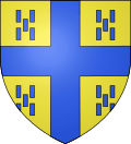 |
Blazon: Or, a cross Azure cantoned with 20 billets the same, 5 per canton saltirewise. |
Administration
| From | To | Name | Party | Position |
|---|---|---|---|---|
| 2001 | 2014 | André Barthelme | ||
| 2014 | 2020[11] | Emmanuel Eschrich |
(Not all data is known)
Demography
In 2010 the commune had 265 inhabitants. The evolution of the number of inhabitants is known from the population censuses conducted in the commune since 1793. From the 21st century, a census of communes with fewer than 10,000 inhabitants is held every five years, unlike larger communes that have a sample survey every year.[Note 1]
| 1793 | 1800 | 1806 | 1821 | 1831 | 1836 | 1841 | 1846 | 1851 |
|---|---|---|---|---|---|---|---|---|
| 279 | 252 | 339 | 387 | 429 | 429 | 400 | 423 | 406 |
| 1856 | 1861 | 1866 | 1872 | 1876 | 1881 | 1886 | 1891 | 1896 |
|---|---|---|---|---|---|---|---|---|
| 399 | 398 | 377 | 380 | 353 | 331 | 306 | 287 | 269 |
| 1901 | 1906 | 1911 | 1921 | 1926 | 1931 | 1936 | 1946 | 1954 |
|---|---|---|---|---|---|---|---|---|
| 287 | 296 | 296 | 259 | 252 | 244 | 249 | 218 | 217 |
| 1962 | 1968 | 1975 | 1982 | 1990 | 1999 | 2006 | 2010 | - |
|---|---|---|---|---|---|---|---|---|
| 213 | 216 | 197 | 187 | 234 | 232 | 260 | 265 | - |
Sources : Ldh/EHESS/Cassini until 1962, INSEE database from 1968 (population without double counting and municipal population from 2006)


Culture and heritage
Architecture
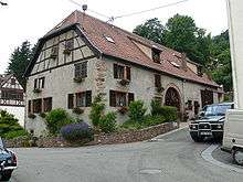
Bassemberg developed along the road from Villé to Lalaye. The buildings followed the shape of the village street in an S shape. Their placement took into account the presence of the river. The buildings located on the floodplain have placed their storerooms on the ground floor with the living areas on the first floor. The houses have adopted the layout of Vosges type farms. The buildings are generally parallel to the street and, successively starting from the front: a gable wall, an arched entrance to the cellar, an access door to the house, an arched door to the barn, and a stable door. Some buildings date back to the 18th century. They are mostly modest sized buildings. Often due to lack of space they were joined in groups of two or three.
Civil heritage

- Milestones. The southern part of the ancient forest of Honcourt Abbey was bordered by milestones in 1757 which served as a border between Bassemberg and Saint-Martin. On the boundary between Villé and Bassemberg there are also four milestones from 1769 with the emblem of Villé.
- Second Empire Bench. At the exit from Bassemberg towards Fouchy on the left of the D39 is a bench in good condition from the Second Empire. It is one of five benches that were preserved in 1854 in the Val de Villé. They were erected in honor of the Empress Eugénie de Montijo.
The commune has a number of buildings and sites that are registered as historical monuments:
- The Town Hall and School Buildings (1838)

- A Farmhouse at 53 Rue Principale (19th century)

- A Farmhouse at 60 Rue Principale (1811)
- A Farmhouse at 62 Rue Principale (1718)
- A House at 67,68 Rue Principale (18th century)
- Houses and Farms (20th century)
Religious heritage
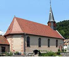


The Church of Saint Quirin![]()
- A Painting with frame: Baptism of the Tribune Quirin (1879)
- The Furniture in the Church
- A Monumental Cross: Christ on the Cross (1737)
- A Chalice with box (18th century)
- A Wayside Cross (1765)
Bassemberg has nine Calvary (shrine)|Calvaries]] still in perfect condition including five dating to the 18th century. The calvary in the old cemetery is the best preserved. Moved by the municipality for development, it is well protected by the long wall of the church. A finely carved niche surrounds the shaft where the inscription: Meint Testament Soll Sein Am / End Amen Jesus Maria und Joseph (My testament to my end must be Jesus, Mary and Joseph Amen). Below on the pedestal is engraved the year 1737. The Calvary is surrounded by the names of the victims of the two world wars.
Another cross from 1737 stands on the municipal boundary between Bassemberg and Breitenau near a reservoir. It unfortunately suffers from soiling due to two trees. It is a cross-milestone: the letters BB (Bassemberg / Breitenau) are engraved on the stock on either side of a floral pattern. At the foot is a milestone with arms that have been damaged by time and perhaps in the French Revolution. The coat of arms of Rathsamhausen Zum Stein, the one time owner of the lordship of Villé and that of the Grand Chapter of Strasbourg Cathedral, owner of Comte-Ban and therefore Breitenau. Another milestone of the same type is a little further on the way.
The Cemetery (1860)![]()
![]()
Notable people linked to the commune
- Jean-Henri Navert, former priest of Bassemberg.
See also
Bibliography
- Historical Society and Community of communes of the Canton of Villé, The Valley of Villé, a country, of men, a history, 1995, 482 pages. Document used for the writing of this article. (in French)
Notes and references
Notes
- ↑ At the beginning of the 21st century, the methods of identification have been modified by Law No. 2002-276 of 27 February 2002 Archived 6 March 2016 at the Wayback Machine., the so-called "law of local democracy" and in particular Title V "census operations" allows, after a transitional period running from 2004 to 2008, the annual publication of the legal population of the different French administrative districts. For communes with a population greater than 10,000 inhabitants, a sample survey is conducted annually and the entire territory of these communes is taken into account at the end of the period of five years. The first "legal population" after 1999 under this new law came into force on 1 January 2009 and was based on the census of 2006.
References
- ↑ Bassemberg on Lion1906
- ↑ Inhabitants of Bas-Rhin (in French)
- ↑ Competition for Towns and Villages in Bloom website Archived December 10, 2014, at the Wayback Machine. (in French)
- 1 2 3 4 Bassemberg on Google Maps
- 1 2 3 Bassemberg on the Géoportail from National Geographic Institute (IGN) website (in French)
- ↑ Gabriel Auguste Daubrée, Geological and mineralogical description of the department of Bas-Rhin, 1852, p. 60-79 (in French).
- ↑ Bassemtrery on the 1750 Cassini Map
- ↑ The 1790 Cassini Map
- ↑ A German military train that connected Villé to the front then remained fixed on the crest of the Vosges (Chaume de Lusse).
- ↑ List of Mayors of France (in French)
- ↑ List of mayors of Bas-Rhin au 10 April 2014
- ↑ Ministry of Culture, Mérimée IA67012206 Town Hall and School Buildings (in French)
- ↑ Ministry of Culture, Mérimée IA67009408 Farmhouse at 53 Rue Principale (in French)
- ↑ Ministry of Culture, Palissy PM67012881 Tympanum (in French)
- ↑ Ministry of Culture, Mérimée IA67009405 Farmhouse at 60 Rue Principale (in French)
- ↑ Ministry of Culture, Mérimée IA67009406 Farmhouse at 62 Rue Principale (in French)
- ↑ Ministry of Culture, Mérimée IA67009407 House at 67,68 Rue Principale (in French)
- ↑ Ministry of Culture, Mérimée IA67009402 Houses and Farms (in French)
- ↑ Ministry of Culture, Mérimée IA67009404 Church of Saint Quirin (in French)
- ↑ Ministry of Culture, Palissy PM67012880 Painting with frame: Baptism of the Tribune Quirin (in French)
- ↑ Ministry of Culture, Palissy PM67012878 Furniture in the Church (in French)
- ↑ Ministry of Culture, Palissy PM67012877 Monumental Cross: Christ on the Cross (in French)
- ↑ Ministry of Culture, Palissy PM67012876 Chalice with box (in French)
- ↑ Ministry of Culture, Palissy PM67012882 Wayside Cross (in French)
- ↑ Ministry of Culture, Mérimée IA67009404 Cemetery (in French)
- ↑ Ministry of Culture, Palissy PM67012879 Items in the Cemetery (in French)
| Wikimedia Commons has media related to Bassemberg. |