Wœrth
| Wœrth | ||
|---|---|---|
| Commune | ||
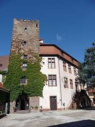 Castle of Wœrth, today town hall and museum | ||
| ||
 Wœrth Location within Grand Est region  Wœrth | ||
| Coordinates: 48°56′23″N 7°44′47″E / 48.9397°N 7.7464°ECoordinates: 48°56′23″N 7°44′47″E / 48.9397°N 7.7464°E | ||
| Country | France | |
| Region | Grand Est | |
| Department | Bas-Rhin | |
| Arrondissement | Haguenau-Wissembourg | |
| Canton | Reichshoffen | |
| Intercommunality | Sauer-Pechelbronn | |
| Government | ||
| • Mayor (2014-2020) | Alain Fuchs | |
| Area1 | 6.47 km2 (2.50 sq mi) | |
| Population (2014)2 | 1,740 | |
| • Density | 270/km2 (700/sq mi) | |
| Time zone | UTC+1 (CET) | |
| • Summer (DST) | UTC+2 (CEST) | |
| INSEE/Postal code | 67550 /67360 | |
| Elevation |
160–242 m (525–794 ft) (avg. 170 m or 560 ft) | |
|
1 French Land Register data, which excludes lakes, ponds, glaciers > 1 km2 (0.386 sq mi or 247 acres) and river estuaries. 2 Population without double counting: residents of multiple communes (e.g., students and military personnel) only counted once. | ||

Wœrth or Woerth (German: Wörth an der Sauer) is a commune in the Bas-Rhin department in Grand Est in north-eastern France.
It lies 45 km (28 mi) north of Strasbourg. Wœrth is known for the Battle of Wœrth, in the initial stage of the Franco-Prussian War in August 1870. The Château de Wœrth houses the mairie since 1977.
Notable people
- Wynkyn de Worde (??-1534)
- Eugène Wintzweiller (1844–1870)
Gallery
.jpg) The river Sauer in Wœrth
The river Sauer in Wœrth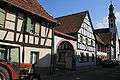 Buildings in the old area of Wœrth
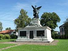 Bavarian monument in Wœrth
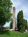 French monument
.jpg) Battlefield's belvedere
Battlefield's belvedere
See also
Sources
References
External links
| Wikimedia Commons has media related to Wœrth. |
| Authority control |
|---|
This article is issued from
Wikipedia.
The text is licensed under Creative Commons - Attribution - Sharealike.
Additional terms may apply for the media files.