Bœsenbiesen
| Bœsenbiesen Biese | ||
|---|---|---|
| Commune | ||
 | ||
| ||
 Bœsenbiesen Location within Grand Est region  Bœsenbiesen | ||
| Coordinates: 48°13′44″N 7°33′54″E / 48.2289°N 7.565000°ECoordinates: 48°13′44″N 7°33′54″E / 48.2289°N 7.565000°E | ||
| Country | France | |
| Region | Grand Est | |
| Department | Bas-Rhin | |
| Arrondissement | Sélestat-Erstein | |
| Canton | Sélestat | |
| Intercommunality | Grand Ried | |
| Government | ||
| • Mayor (2001–2008) | Jean-Blaise Loos | |
| Area1 | 3.81 km2 (1.47 sq mi) | |
| Population (2006)2 | 304 | |
| • Density | 80/km2 (210/sq mi) | |
| Time zone | UTC+1 (CET) | |
| • Summer (DST) | UTC+2 (CEST) | |
| INSEE/Postal code | 67053 /67390 | |
| Elevation | 168–173 m (551–568 ft) | |
|
1 French Land Register data, which excludes lakes, ponds, glaciers > 1 km2 (0.386 sq mi or 247 acres) and river estuaries. 2 Population without double counting: residents of multiple communes (e.g., students and military personnel) only counted once. | ||

Bœsenbiesen (German: Bösenbiesen) is a commune in the Bas-Rhin department in Alsace in north-eastern France.
Population
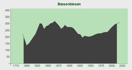
| Historical population | ||||||||||||||||||||||||||||||||||||||||||||||||||||||||||||||||||||||||||||||||||||||||||||||||||||||||||||||||||||
|---|---|---|---|---|---|---|---|---|---|---|---|---|---|---|---|---|---|---|---|---|---|---|---|---|---|---|---|---|---|---|---|---|---|---|---|---|---|---|---|---|---|---|---|---|---|---|---|---|---|---|---|---|---|---|---|---|---|---|---|---|---|---|---|---|---|---|---|---|---|---|---|---|---|---|---|---|---|---|---|---|---|---|---|---|---|---|---|---|---|---|---|---|---|---|---|---|---|---|---|---|---|---|---|---|---|---|---|---|---|---|---|---|---|---|---|---|
|
|
| ||||||||||||||||||||||||||||||||||||||||||||||||||||||||||||||||||||||||||||||||||||||||||||||||||||||||||||||||||
| Source: [1] | ||||||||||||||||||||||||||||||||||||||||||||||||||||||||||||||||||||||||||||||||||||||||||||||||||||||||||||||||||||
See also
References
| Wikimedia Commons has media related to Bœsenbiesen. |
This article is issued from
Wikipedia.
The text is licensed under Creative Commons - Attribution - Sharealike.
Additional terms may apply for the media files.