Mutzig
| Mutzig | |
|---|---|
| Commune | |
 Town hall | |
 Mutzig Location within Grand Est region  Mutzig | |
| Coordinates: 48°32′N 7°28′E / 48.54°N 7.46°ECoordinates: 48°32′N 7°28′E / 48.54°N 7.46°E | |
| Country | France |
| Region | Grand Est |
| Department | Bas-Rhin |
| Arrondissement | Molsheim |
| Canton | Mutzig |
| Government | |
| • Mayor (2014–2020) | Jean-Luc Schickele |
| Area1 | 8.01 km2 (3.09 sq mi) |
| Population (2006)2 | 5,970 |
| • Density | 750/km2 (1,900/sq mi) |
| Time zone | UTC+1 (CET) |
| • Summer (DST) | UTC+2 (CEST) |
| INSEE/Postal code | 67313 /67190 |
| Elevation |
180–397 m (591–1,302 ft) (avg. 193 m or 633 ft) |
|
1 French Land Register data, which excludes lakes, ponds, glaciers > 1 km2 (0.386 sq mi or 247 acres) and river estuaries. 2 Population without double counting: residents of multiple communes (e.g., students and military personnel) only counted once. | |
Mutzig (German: Mützig) is a commune located at the entrance of the Bruche river valley, in the Bas-Rhin department in Grand Est, in north-eastern France. The commune of Mutzig is on the Route des Vins d'Alsace.
History
Evidences of human activities can be traced back to the Paleolithic era with the recent discovery of Neanderthal artifacts. The town Mutzig was first mentioned in the 10th century. It became part of the Prince-Bishopric of Strasbourg in 1308.[1]
In the 19th century, several industries were established in Mutzig among which a weapon manufactory on the grounds of the former castle of the Cardinal de Rohan. In 1893, when Alsace was part of the German Empire, Kaiser Wilhelm II ordered the construction of a fort, the Feste Kaiser Wilhelm II, north of the town, as well as military barracks.
Gallery
 City gate.
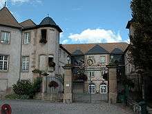
See also
References
- ↑ History of Mutzig (in French)
External links
| Wikimedia Commons has media related to Mutzig. |
| Authority control |
|---|