Wolfisheim
| Wolfisheim | ||
|---|---|---|
| Commune | ||
 | ||
| ||
 Wolfisheim Location within Grand Est region  Wolfisheim | ||
| Coordinates: 48°35′15″N 7°40′02″E / 48.5875°N 7.6672°ECoordinates: 48°35′15″N 7°40′02″E / 48.5875°N 7.6672°E | ||
| Country | France | |
| Region | Grand Est | |
| Department | Bas-Rhin | |
| Arrondissement | Strasbourg | |
| Canton | Hœnheim | |
| Intercommunality | Strasbourg Eurométropole | |
| Government | ||
| • Mayor (2014-2020) | Éric Amiet | |
| Area1 | 5.57 km2 (2.15 sq mi) | |
| Population (2014)2 | 3,974 | |
| • Density | 710/km2 (1,800/sq mi) | |
| Time zone | UTC+1 (CET) | |
| • Summer (DST) | UTC+2 (CEST) | |
| INSEE/Postal code | 67551 /67202 | |
| Elevation |
141–172 m (463–564 ft) (avg. 146 m or 479 ft) | |
|
1 French Land Register data, which excludes lakes, ponds, glaciers > 1 km2 (0.386 sq mi or 247 acres) and river estuaries. 2 Population without double counting: residents of multiple communes (e.g., students and military personnel) only counted once. | ||

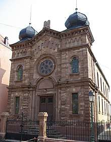
Wolfisheim's long abandoned synagogue has been recently restored
Wolfisheim (Alsatian: Wolfze) is a commune in the Bas-Rhin department in Grand Est in north-eastern France.
See also
References
| Wikimedia Commons has media related to Wolfisheim. |
This article is issued from
Wikipedia.
The text is licensed under Creative Commons - Attribution - Sharealike.
Additional terms may apply for the media files.