Ebro
| Ebro | |
| Catalan: Ebre | |
| River | |
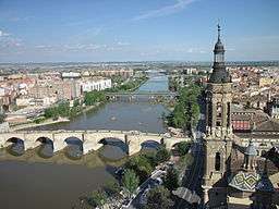 The Ebro River in Zaragoza | |
| Country | Spain |
|---|---|
| Tributaries | |
| - left | Nela, Jerea, Bayas, Zadorra, Ega, Arga. Aragón, Gállego, Segre |
| - right | Oca, Oja, Tirón, Najerilla, Iregua, Cidacos, Alhama, Jalón, Huerva, Martín, Guadalope, Matarranya |
| Source | |
| - location | Fontibre, Cantabria, Spain |
| - elevation | 1,980 m (6,496 ft) |
| - coordinates | 43°02′20.80″N 4°24′10.59″W / 43.0391111°N 4.4029417°W |
| Mouth | |
| - location | Mediterranean Sea, Tarragona, Spain |
| - elevation | 0 m (0 ft) |
| - coordinates | 40°43′12″N 0°51′47″E / 40.72000°N 0.86306°ECoordinates: 40°43′12″N 0°51′47″E / 40.72000°N 0.86306°E |
| Length | 930 km (578 mi) |
| Basin | 80,093 km2 (30,924 sq mi) |
| Discharge | mouth |
| - average | 426 m3/s (15,044 cu ft/s) |
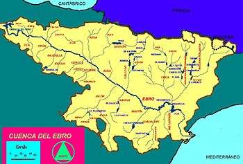 The Ebro river basin | |
The Ebro (Spanish and Basque pronunciation: [ˈeβɾo]; Catalan: Ebre [ˈeβɾə]) is a river on the Iberian Peninsula. It is the second longest river in the Iberian peninsula after the Tagus and the second biggest by discharge volume and by drainage area after the Douro.
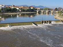
The Ebro flows through the following cities: Reinosa in Cantabria; Frías and Miranda de Ebro in Castile and León; Haro, Logroño, Calahorra, and Alfaro in La Rioja; Tudela in Navarre; Alagón, Utebo, Zaragoza, and Caspe in Aragon; and Flix, Móra d'Ebre, Benifallet, Tivenys, Xerta, Aldover, Tortosa, and Amposta in Catalonia.
Geography
The source of the river Ebro is in Fontibre (Cantabria), from the Latin words Fontes Iberis, source of the Ebro. Close by is a large artificial lake, Embalse del Ebro, created by the damming of the river. The upper Ebro rushes through rocky gorges in Burgos Province. Flowing roughly eastwards it begins forming a wider river valley of limestone rocks when it reaches Navarre and La Rioja thanks to many tributaries flowing down from the Iberian System on one side, and the Navarre mountains and the western Pyrenees, on the other. There, the climate (the valley being isolated from sea air masses by surrounding mountains) becomes progressively more continental, with more extreme temperatures and drier characteristics, and therefore typically experiencing hot (sometimes very hot) and dry summers which closely resemble summers seen in arid and semiarid climates.
Karst geological processes shaped the landscape of layers of soluble carbonate rock of extensive limestone bedrock formed in an ancient seabed. Aragonite, a mineral named for Aragon, attests to the fact that carbonates are abundant in the central Ebro Valley.
The valley expands and the Ebro's flow then becomes slower as its water volume increases, flowing across Aragon. There, larger tributaries flowing from the central Pyrenees and the Iberian System discharge large amounts of water, especially in spring during the thawing season of the mountain snow. As it flows through Zaragoza the Ebro, is already a sizeable river. There, the Basilica of Our Lady of the Pillar stands next to the Ebro. The soils in most of the valley are primarily poor soils: calcareous, pebbly, stony, and sometimes salted with saltwater endorheic lagoons. The semi-arid interior of the Ebro Valley has either drought summers and a semi-desert climate with rainfall between 400 and 600 mm (16–24 in), with a maximum in the fall and spring. It is covered with chaparral vegetation. Summers are hot and winters are cold. The dry summer season has temperatures of more than 35 °C (95 °F), occasionally reaching over 40 °C (104 °F). In winter, the temperatures often drop below 0 °C (32 °F). In some areas the vegetation depends heavily on moisture produced by condensation fog. It is a continental Mediterranean climate with extreme temperatures. There are many ground frosts on clear nights, and sporadic snowfalls.
The biomes are diverse in these Mediterranean climate zones: Mediterranean forests, woodlands, and scrub. Hinterlands are particularly distinctive on account of extensive sclerophyll shrublands known as maquis, or garrigues. The dominant species are Quercus coccifera (in drier areas) and Quercus ilex. These trees form monospecific communities or communities integrated with Pinus, Mediterranean buckthorns, Myrtus, Chamaerops humilis, junipers, Pistacia, Rosmarinus, Thymus, and so on.
The hinterland climate becomes progressively more continental and drier, and therefore there is an end from extreme temperatures accompanied by slow-growing dwarf juniper species to unvegetated desert steppes as in "llanos de Belchite" or "Calanda desert".
The mountain vegetation is mostly coniferous forests that are drought adapted, and trees in the genus Quercus with different drought tolerance in the wetter highlands.
Halophiles extremophile characteristic communities are frequent in endorheic areas such as lagoons and creeks, which are Tamarix covered and include endemic species of bryophytes, chenopodiaceas, plumbaginacea, ruppiaceaes, Carex, lythraceaes, asteraceaes, etc. Their presence is related to the marine origin of the Ebro valley and the extensive marine deposits in the same area.
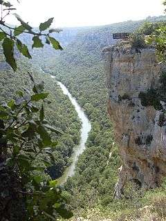
After reaching Catalonia, the Ebro Valley narrows, and the river becomes constrained by mountain ranges, making wide bends. Massive dams have been built in this area, such as the dams at Mequinenza, Riba-roja and Flix. In the final section of its course the river bends southwards and flows through spectacular gorges. The massive calcareous cliffs of the Serra de Cardó range constrain the river during this last stretch, separating the Ebro Valley from the Mediterranean coastal area. After passing the gorges, the Ebro bends again eastwards near Tortosa before discharging in a delta on the Mediterranean Sea close to Amposta in the province of Tarragona.
Delta geography
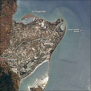
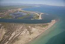
The Ebro Delta (Catalan: Delta de l'Ebre), in the Province of Tarragona, Catalonia, is at 340 km2 (130 sq mi) one of the largest wetland areas in the western Mediterranean region. The delta has expanded rapidly on soils washed downriver—the historical rate of growth of the delta is demonstrated by the town of Amposta. A seaport in the 4th century, it is now well inland from the current rivermouth. The rounded form of the delta attests to the balance between sediment deposition by the Ebro and removal of this material by wave erosion.
The modern delta is in intensive agricultural use for rice, fruit (in particular citrus), and vegetables. The Ebro delta also has numerous beaches, marshes, and salt pans that provide habitat for over 300 species of birds. In 1983 Spain designated a large part of the delta as the Ebro Delta Natural Park (Catalan: Parc Natural del Delta de l'Ebre) to protect its natural resources.[1] A network of canals and irrigation ditches constructed by both agricultural and conservation groups are helping to maintain the ecologic and economic resources of the Ebro Delta.
Name
The Greeks called the river Ἴβηρ (Ibēr), and the Romans called it the Hibēr, Ibēr, or Ibērus flūmen, leading to its current name. The Iberian peninsula and the Hibērī or Ibērī (the people of the area) were named after the river.[2] It is not known with any certainty whether the Greeks used a local native name for the river, nor what the word "Ibēr" or "Hibēr" might mean. In modern Basque the word ibar means 'valley' or 'watered meadow', while ibai means 'river', but there is no proof relating the etymology of the Ebro River with these Basque words. However, there are rivers in the Balkans called Ibar (Montenegro, Serbia and Kosovo) and Evros (Bulgaria and Greece).
History
In antiquity, the Ebro was used as the dividing line between Roman (north) and Carthaginian (south) expansions after the First Punic War (264–241 BC). When the Roman Republic, fearful of Hannibal's growing influence in the Iberian Peninsula, made the city of Saguntum (considerably south of the Ebro) a protectorate of Rome, Hannibal viewed the treaty violation as an aggressive action by Rome and used the event as the catalyst to the Second Punic War.
One of the earliest Cistercian monasteries in Spain, Real Monasterio de Nuestra Señora de Rueda (lit. Royal Monastery of Our Lady of the Wheel), is located on the banks of the Ebro in Aragon. Established in 1202, the edifice survives intact. The monastery is strongly connected to the Ebro, since it used one of the first large waterwheels built for the production of power in Spain. The monastery also diverted flow from the Ebro to create a circulating, hydrological central heating system for its buildings.
The Ebro in 1938 was the starting ground of one of the most famous Republican offensives of the Spanish Civil War. Known as the Battle of the Ebro, the offensive ended in defeat for the Republican forces, although they enjoyed success in its first stages. They were not able to reach their objective of Gandesa.
Flow and floods
The Ebro is the most important river in Spain in terms of length, 928 km (577 mi), and area of drainage basin, 85,550 km2 (33,030 sq mi). However, the mean annual flow decreased by approximately 29 percent during the 20th century due to many causes: the construction of dams, the increasing demands for irrigation and the evaporation (higher than the rainfall, due to low rainfall, high sunshine and strong and dry winds) from reservoirs in the river basins. This situation has a direct impact on the deltaic system at the mouth of the river because its hydrological dynamics are mainly controlled by the river discharge.
The decrease in river discharge has meant introduction of the salt wedge further into the river. The mean annual river flow is approximately the critical flow which determines the formation and the break-up of the salt wedge. Thus, when the river discharge is between 300 and 400 m3/s (11,000 and 14,000 cu ft/s), the salt wedge can occupy the last 5 km (3 mi) of the estuary, but when the discharge is between 100 and 300 m3/s (3,500 and 10,600 cu ft/s), the salt wedge can advance up to 18 km (11 mi) from the mouth. For less than 100 m3/s (3,500 cu ft/s), the salt wedge quickly advances to its maximum extent, reaching 32 km (20 mi) from the mouth. In addition to decreased mean annual flow, the increased river regulation in the Ebro basin has produced daily and seasonal changes in the flow pattern.
With regards to the sediment load, several authors conclude that the sediment load was reduced by more than 99 percent during the last century. The drastic reduction in sediment transport implies a sediment deficit in the delta, which is causing the erosion of the coastline and lack of sediment replenishment. The unstable surface is due to weather changes and tidal surges. The river floods from time to time, although advance warning can now be given as a result of monitoring within the catchment area. The river flow in Zaragoza during floods, from the end of the 19th century is as follows:
|
|
|
The Ebro poured 1,874 million cubic metres (1,519,000 acre feet) into the delta from 27 March 2007 to 11 April 2007, with an average of 117 million cubic metres (95,000 acre feet) per day.
Ecology
There are concerns about the ecological impact of dams, pollution from populations, factories, and agricultural dumping. Invasive species are also a burden, affecting much of the original ecosystem; the introduced species have rapidly caused the extinction of numerous indigenous species.
In past times numerous lagoons, endorheic saltwater ponds, and freshwater swamps and marshes were drained, dried or filled. Almost entire riparian forests were cleared for crops or for pulpwood forest plantations. Due to these changes numerous plant and animal species have disappeared. Due to dams and hydraulic canalization, the dynamics of the river have been altered and new scroll-bars, new oxbow lakes, and new abandoned meanders will not now be created. Over a period of time, many of these phenomena tend to dry out or fill in with sediments. Some small representatives of these river dynamics and wetlands are protected.
The Ebro Delta Natural Park, with a total surface area of 7,802 hectares (19,280 acres), was established in 1986 and is of international importance for 8 of its plant species and 69 of its vertebrate fauna. It has some 95 breeding species of birds, is also very important for a wide range of overwintering species, and serves as an essential stopover point for large numbers of migratory birds. The Ebro delta has the world's largest colony of Audouin's gulls. In 2006 it held a record number of more than 15,000 pairs, its highest to date.
The introduction of American crayfish Procambarus clarkii has resulted in economic losses, introduced elsewhere for cultivation, its success is attributable to its ability to colonise disturbed habitats that would be unsuitable for the edible iberian crayfish. The semiaquatic rodent Myocastor coypus or nutria is beginning to expand in some northwest tributaries of the head damaging crops and protected national parks in the Basque Country. Fish caught in the Ebro are high in mercury and the European Union prohibits the sale of Ebro fish, notably the huge Wels catfish.
The zebra mussel, an invasive species, is expanding upstream in the Ebro's waters. Due to its rapid rate of reproduction, the species adversely affects the port's underwater machinery as well as that of dams and hydroelectric plants, in addition to competing with native species. Following the introduction of Wels catfish, many fish species' numbers are in clear and rapid decline. Since the Wels catfish's introduction in the Mequinenza reservoir in 1974, it has spread to other parts of the Ebro and its tributaries, especially the Segre. Some endemics species of iberian barbels, genus Barbus in the Cyprinidae, having once been abundant especially in the Ebro. Competition and predation by Wels catfish has caused its complete disappearance in the middle channel Ebro around 1990. The ecology of the river also now has a major development in the amount of aquatic vegetation, seaweed and algae. Barbel species from mountain stream tributaries of the Ebro that Wels catfish have not colonized were not affected.
See also
Notes
- ↑ Ebro Delta Natural Park Archived 2008-01-15 at the Wayback Machine.
- ↑ Westrem, Scott D. The Hereford Map: A Transcription and Translation of the Legends With Commentary, page 328. Brepols, 2001.
References
- "Ebro River Delta, Northeastern Spain". NASA Earth Observatory. Archived from the original on 2006-09-30. Retrieved 2006-05-24.
- Ebro in the Columbia Encyclopedia
External links
| Wikimedia Commons has media related to Ebro River. |

- The River Ebro and Delta
- The Ebro Delta from Space
- The Ebro Delta at Google Maps
- Photo gallery of the Ebro Delta and surrounding area: birds, landscapes and people
- The Trinidad Salt Pans within the Ebro River Delta Nature Reserve
- Awarded "EDEN - European Destinations of Excellence" non traditional tourist destination 2009