Richmond Hill station (LIRR)
Richmond Hill | ||||||||||||||||
|---|---|---|---|---|---|---|---|---|---|---|---|---|---|---|---|---|
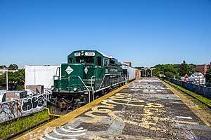 Platform viewed in 2018 | ||||||||||||||||
| Location |
Hillside Avenue and Babbage Streets Richmond Hill, Queens, New York | |||||||||||||||
| Coordinates | 40°42′02″N 73°49′56″W / 40.70056°N 73.83222°WCoordinates: 40°42′02″N 73°49′56″W / 40.70056°N 73.83222°W | |||||||||||||||
| Owned by | Long Island Rail Road | |||||||||||||||
| Line(s) | Montauk Branch | |||||||||||||||
| Platforms | 1 island platform | |||||||||||||||
| Tracks | 2 | |||||||||||||||
| History | ||||||||||||||||
| Opened | 1869 | |||||||||||||||
| Closed | March 16, 1998 | |||||||||||||||
| Rebuilt | 1923 | |||||||||||||||
| Electrified | August 29, 1905 | |||||||||||||||
| Previous names | Clarenceville (1869–1871) | |||||||||||||||
| Services | ||||||||||||||||
| ||||||||||||||||
Richmond Hill is a closed station on the Montauk Branch of the Long Island Rail Road in the Richmond Hill neighborhood of Queens, New York City. The station is located at Myrtle Avenue and cuts diagonally from the intersection of Jamaica Avenue and Lefferts Boulevard through an unnumbered section of Hillside Avenue.
History
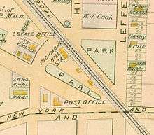
Richmond Hill station was originally built by the South Side Railroad of Long Island in 1869 as Clarenceville station,[1][2][3] which is not to be confused with the nearby Clarenceville station on the Atlantic Branch. Clarenceville was a farming community centered around Jamaica and Greenwood Avenues (the latter now 111th Street, where the Atlantic Branch station was located), which is now part of Richmond Hill.[4] The Richmond Hill neighborhood was founded in 1868, with the purchase of the Lefferts and Welling farms by Albon Platt Man.[4][5] The station name was changed to Richmond Hill in November 1871.[1] It had two tracks with a station house on one side and an enclosed wooden shelter on the other.[1]
In 1911, New York City and the Long Island Rail Road began negotiating the elimination of numerous at-grade crossings within Queens.[6][7] In 1917, the LIRR finalized the grade crossing elimination project plans for the Montauk Branch in the Richmond Hill area, which would construct a new elevated station between Park Street (today's Hillside Avenue) and Lefferts Avenue (now Lefferts Boulevard).[8] During the project, the wooden station was temporarily relocated.[7] The current station opened in 1923.[1] The project eliminated numerous at-grade crossings in the vicinity of the station, including those at St. Anne Avenue (now 84th Avenue), Ashland Avenue (now 85th Avenue), Park Street, the intersection of Jamaica and Lefferts Avenue, and Ridgewood Avenue (now 89th Avenue). It also extended the roads adjacent to the right-of-way then known as Railroad Avenue (now Babbage Street and Bessemer Street) east to Lefferts Avenue.[6][8][9][10]
The station was closed on March 16, 1998, along with nine others (including the other four on the Lower Montauk branch) due to low ridership and the potential cost of upgrading the stations to modern standards (this station and Penny Bridge, also on the Lower Montauk, had just one daily rider each at the time of their closure).[11] The station and platform remain, though access via the staircase at Jamaica Avenue is gated off.[12][13][14] Shortly after the station's closure, the station became a hotbed for the homeless along with animals, and an illegal waste dumping site.[12][13][15][16][17][18] In July 2003, new security fencing was installed around the trestle,[12][15][16] though maintenance problems have continued into the present day.[18]
Station layout
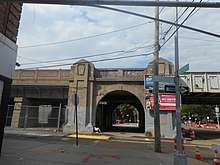
The station has two tracks and an island platform. Richmond Hill was the only station on the Lower Montauk Branch that was elevated with a high-level platform for passengers to wait for trains (the other four stations only had strips of pavement beside the tracks, requiring passengers to wait on track level and climb aboard trains).[19][20] The station sits on a concrete trestle, supported by pairs of concrete arches.[8][14][21] The station's island platform has a small shelter in the center, and two stairways down to the street. One staircase goes down from the shelter to Hillside Avenue. The other is at the south (railroad east) end that goes down to the three-way intersection of Myrtle Avenue, Lefferts Boulevard and Jamaica Avenue. The southern staircase is blocked by a security gate, and retains the sign from 1998 announcing the closure of the station.[8][14][19] The platform could accommodate trains of six 85-foot (26 m) cars.[20]
Most of the space underneath the trestle between Lefferts Boulevard and Hillside Avenue is gated off by green fencing, installed in 2003.[16] The area has been used as parking space in the past.[12][13][15][16]
The Jamaica elevated (serving the New York City Subway's J and Z trains) runs over the Montauk Branch tracks along Jamaica Avenue. This section of the elevated was opened in 1917 by the Brooklyn–Manhattan Transit Corporation (BMT), built after the LIRR station.[22] The closest station is two blocks east at 121st Street.[23]
References
- 1 2 3 4 David D. Morrison; Valerie Pakaluk (2003). Long Island Rail Road Stations. Arcadia Publishing. pp. 40–41. ISBN 978-0-7385-1180-1.
- ↑ "(untitled)". Queens County Sentinel. Fultonhistory.com. April 29, 1869. Retrieved August 21, 2016.
The frame of the new depot building at Clarenceville is now up, and will be inclosed next week. A platform some 300 feet in length is to be laid. It is to be of Gothic style, 20x60 feet, 15 feet posts.
- ↑ "South Side Railroad". New York Evening Post. Fultonhistory.com. June 1, 1869. Retrieved August 21, 2016.
- 1 2 Orman, John (October 27, 1972). "Historical Notes on Richmond Hill". Leader-Observer. Fultonhistory.com. Retrieved August 21, 2016.
- ↑ Carl Ballenas (2011). Jamaica. Arcadia Publishing. pp. 102, 105. ISBN 978-0-7385-7426-4. Retrieved August 21, 2016.
- 1 2 "Remove Grade Crossings; The City of New York and the Long Island Railroad Execute a Contract to Spend Two Millions; The City Will Pay $575,000". The Daily Long Island Farmer. Fultonhistory.com. July 29, 1911. p. 1. Retrieved August 21, 2016.
- 1 2 "One Crossing Is Going". Leader-Observer. Fultonhistory.com. March 1, 1923. p. 1. Retrieved August 21, 2016.
- 1 2 3 4 "To Elevate L.I. Tracks at Richmond Hill: Company Promises To Soon Eliminate Grade Crossings; System May Be Electrified". Leader-Observer. Fultonhistory.com. February 22, 1917. p. 8. Retrieved August 21, 2016.
- ↑ "Calls Atlantic Division Grade Crossings Most Dangerous In City". Leader-Observer. Fultonhistory.com. November 1, 1923. p. 1. Retrieved August 21, 2016.
- ↑ Peters, Ralph (March 1, 1913). "What the Improvements Mean to the Public". Brooklyn Daily Eagle. Fultonhistory.com. p. 2. Retrieved August 21, 2016.
- ↑ Sengupta, Somini (March 15, 1998). "End of the Line for L.I.R.R.'s 10 Loneliest Stops". The New York Times. Retrieved August 7, 2009.
- 1 2 3 4 Simon, David (January 30, 2003). "Rundown Rich. Hill LIRR Station To Receive $75,000 Overhaul". Queens Chronicle. Retrieved August 21, 2016.
- 1 2 3 Davidson, Alex (October 17, 2002). "Abandoned railroad station mars face of Richmond Hill". Times Ledger. Retrieved August 21, 2016.
- 1 2 3 Walsh, Kevin (March 7, 2010). "MYRTLE AVENUE Part 4, Glendale, Forest Park, Richmond Hill". Forgotten New York. Retrieved August 21, 2016.
- 1 2 3 Davidson, Alex (January 16, 2003). "Richmond Hill LIRR site to get $75,000 overhaul". Times Ledger. Retrieved August 21, 2016.
- 1 2 3 4 Joiner, Bryan (July 31, 2003). "Richmond Hill LIRR Station Gets Taller And Stronger Fence". Queens Chronicle. Retrieved August 21, 2016.
- ↑ Serant, Claire (October 7, 1998). "LIRR Underpass Stinks, Say Locals". Daily News (New York). Retrieved August 21, 2016.
- 1 2 O’Reilly, Anthony (February 11, 2016). "LIRR blight presents a chance 'for crime': CB 9 member calls for proper agency to clean Richmond Hill site". Queens Chronicle. Retrieved August 21, 2016.
- 1 2 Walsh, Kevin (April 2000). "LONG ISLAND RAIL ROAD RETIRED FLEET". Forgotten New York. Retrieved August 21, 2016.
- 1 2 Queens Subway Options Study, New York: Environmental Impact Statement. United States Department of Transportation, Metropolitan Transportation Authority, Urban Mass Transit Administration. May 1984. Retrieved July 10, 2016.
- ↑ Cohen, Joyce (April 13, 1997). "Working-Class, With Touch of Nostalgia". The New York Times. Retrieved August 21, 2016.
- ↑
- "TO OPEN JAMAICA AV. LINE.; Nearly Two and a Half Miles Ready for Operation Tonight" (May 27, 1917). New York Times Company. May 27, 1917. p. 24. Retrieved April 21, 2015.
- "Jamaica Avenue 'L' is an Old Story Already" (PDF) (May 31, 1917). Leader Observer (Queens/Brooklyn, NY). May 31, 1917. p. 1. Retrieved April 20, 2015.
- Report of the Public Service Commission for the First District of the State of New York, Volume 1. New York State Public Service Commission. January 15, 1918. pp. 73, 81, 312–314. Retrieved April 20, 2015.
- ↑ "MTA Neighborhood Maps: Kew Gardens" (PDF). mta.info. Metropolitan Transportation Authority. 2018. Retrieved October 1, 2018.
External links
| Wikimedia Commons has media related to Richmond Hill (LIRR station). |