Sayat
| Sayat | |
|---|---|
| Commune | |
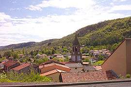 View of Sayat in 2004 | |
 Sayat Location within Auvergne-Rhône-Alpes region  Sayat | |
| Coordinates: 45°49′38″N 3°03′12″E / 45.8272°N 3.0533°ECoordinates: 45°49′38″N 3°03′12″E / 45.8272°N 3.0533°E | |
| Country | France |
| Region | Auvergne-Rhône-Alpes |
| Department | Puy-de-Dôme |
| Arrondissement | Riom |
| Canton | Cébazat |
| Intercommunality | Volvic Sources et Volcans |
| Government | |
| • Mayor (2014–2020) | Nicolas Weinmeister |
| Area1 | 8.29 km2 (3.20 sq mi) |
| Population (2012)2 | 2,155 |
| • Density | 260/km2 (670/sq mi) |
| Time zone | UTC+1 (CET) |
| • Summer (DST) | UTC+2 (CEST) |
| INSEE/Postal code | 63417 /63530 |
| Elevation |
390–818 m (1,280–2,684 ft) (avg. 440 m or 1,440 ft) |
|
1 French Land Register data, which excludes lakes, ponds, glaciers > 1 km2 (0.386 sq mi or 247 acres) and river estuaries. 2 Population without double counting: residents of multiple communes (e.g., students and military personnel) only counted once. | |
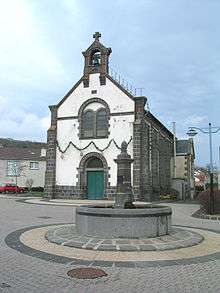
Façade of the village church in Argnat topped by a bell-gable
Sayat is a commune in the Puy-de-Dôme department in Auvergne in central France.
Geography
Villages
- Argnat
small village up from Sayat, historically divided in two parts : "Argnat" and "Le Mas d'Argnat".
See also
References
External links
| Wikimedia Commons has media related to Sayat. |
This article is issued from
Wikipedia.
The text is licensed under Creative Commons - Attribution - Sharealike.
Additional terms may apply for the media files.