Hoggar Mountains
| Hoggar Mountains | |
|---|---|
|
جبال هقار Idurar Ahaggar Idurar n Uhaggar | |
 Landscape of the Assekrem region in the Hoggar in Tamanrasset Province | |
| Highest point | |
| Peak | Mount Tahat |
| Elevation | 2,908 m (9,541 ft) |
| Coordinates | 23°17′20″N 05°32′01″E / 23.28889°N 5.53361°ECoordinates: 23°17′20″N 05°32′01″E / 23.28889°N 5.53361°E |
| Geography | |
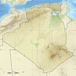 Hoggar Mountains Location in southern Algeria | |
| Country | Algeria |
| Hoggar National Park | |
|---|---|
|
IUCN category II (national park) | |
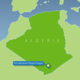 Locator map | |
| Location | Tamanrasset Province, Algeria |
| Nearest city | Tamanrasset |
| Coordinates | 22°08′N 6°10′E / 22.133°N 6.167°E |
| Area | 3,800 km2 (1,500 sq mi) |
| Established | 1987 |
The Hoggar Mountains (Arabic: جبال هقار, Berber: idurar n Ahaggar, Tuareg: Idurar Uhaggar), also known as the Ahaggar Mountains, are a highland region in the central Sahara, southern Algeria, along the Tropic of Cancer. The mountains cover an area of approximately 550,000 square km (212,000 square miles).[1]
Geography
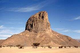
This mountainous region is located about 1,500 km (930 mi) south of the capital, Algiers. The area is largely rocky desert with an average elevation of more than 900 m (3,000 ft) above sea level. The highest peak, Mount Tahat, is at 2,908 m (9,541 ft).[1] The mountains are primarily composed of metamorphic rock approximately 2 billion years old, although there are areas where more recent volcanic activity has laid down much newer rock.[1] Several of the more dramatic peaks, such as Ilamen, are the result of erosion wearing away extinct volcano domes, leaving behind the more resistant material that plugged the volcanic cores.[1]
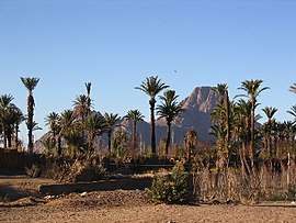
Assekrem is a famous and often visited point where Charles de Foucauld built a hermitage in 1911.[2] The main city near the Hoggar Mountains is Tamanrasset, built in a desert valley or wadi.
Environment
The Hoggar Mountain range typically experiences hot summers, with a cold winter climate. Temperatures fall below 0 °C (32 °F) in the winter. Rainfall is rare and sporadic year-round. However, since the climate is less extreme than in most other areas of the Sahara, the Hoggar Mountains are a major location for biodiversity, including number of relict species. The Hoggar Mountains are part of the West Saharan montane xeric woodlands ecoregion. It is also one of the national parks of the country.
Fauna and flora
Slightly to the west of the Hoggar range, a population of the endangered African wild dog (Lycaon pictus) remained viable into the 20th century, but is now thought to be extirpated within this entire region.[3]
Analysis of collected scat in 2006 showed the presence of the Northwest African Cheetah in the region.[4][5]
Relict populations of the West African crocodile persisted in the Hoggar Mountains until the early 20th century.[6]
The park also contains a population of herbivores such as the saharan subspecies of the barbary sheep and the Dorcas gazelle [7]
Vegetation in this area includes trees such as Vachellia tortilis, Vachellia seyal, myrtle and Tamarix aphylla which are scattered throughout the area. Other plants may include Citrullus colocynthis and Calotropis procera.
Cultural significance
Prehistoric settlement is evident from extant rock paintings dating to 6000 BC.[8] The Hoggar Massif is the land of the Kel Ahaggar Tuareg.[1] The tomb of Tin Hinan, the woman believed to be the matriarch of the Tuareg, is located at Abalessa, an oasis near Tamanrasset. According to legend, the Tim Lam are from the Tafilalt region in the Moroccan Atlas Mountains.
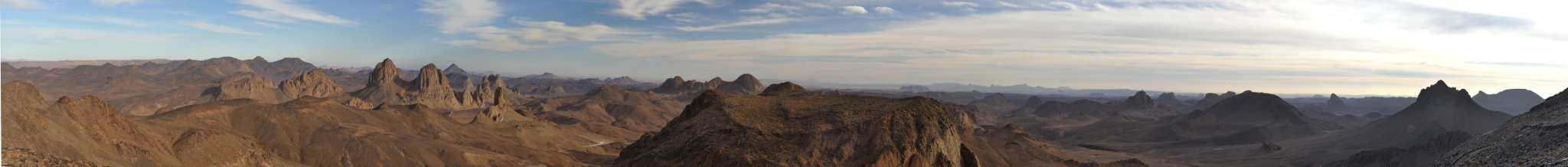
Panoramic view
See also
References
- 1 2 3 4 5 Scheffel, Richard L.; Wernet, Susan J., eds. (1980). Natural Wonders of the World. United States of America: Reader's Digest Association, Inc. pp. 32–33. ISBN 0-89577-087-3.
- ↑ Sattin, Anthony Ham, Nana Luckham, Anthony (2007). Algeria (1st ed.). Footscray, Vic.: Lonely Planet. p. 188. ISBN 1741790999.
- ↑ C. Michael Hogan. 2009
- ↑ see Busby, 2006, http://users.ox.ac.uk/~some2456/docs/Busby_GBJ_North_African_Cheetah_thesis.pdf.
- ↑ "Report" (PDF). users.ox.ac.uk. 2006.
- ↑ "Crocodiles in the Sahara Desert: An Update of Distribution, Habitats and Population Status for Conservation Planning in Mauritania". PLOS ONE. February 25, 2011.
- ↑ "Ahaggar National Park, Hoggar | By Algeria Channel". www.algeria.com. Retrieved 2017-09-15.
- ↑ Peter Haggett. 2001
Further reading
- Peter Haggett. 2001. Encyclopedia of World Geography, Published by Marshall Cavendish, 3456 pages ISBN 0-7614-7289-4, 9780761472896
- C. Michael Hogan. 2009. Painted Hunting Dog: Lycaon pictus, GlobalTwitcher.com, ed. N. Stromberg
- Jeremy Keenan. 1977. "The Tuareg: People of Ahaggar", Published by Allen Lane, Penguin Books Ltd., London, 385 pages, ISBN 0-7139-0636-7
External links
| Wikimedia Commons has media related to Ahaggar Mountains. |
- (in French) A website about the park
- Park data on UNEP-WPMC
- Ahaggar National Park - The Biodiverse Home of the Saharan Cheetah
| Tell Atlas |
|
|---|---|
| Saharan Atlas |
|
| Saharan massifs | |
| Peaks |
|