Adrar des Ifoghas
| Adrar des Ifoghas | |
|---|---|
| Adrar n Ifoghas | |
 View of a guelta near Oubankort | |
| Highest point | |
| Elevation | 890 m (2,920 ft) |
| Geography | |
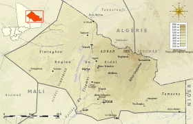 Topographic map of the Kidal Region
| |
| Location | Central Sahara |
| Countries | Mali and Algeria |
| States/Provinces | Kidal Region, Tamanrasset and Adrar |
The Adrar des Ifoghas (also Adrar des Iforas; Tamasheq: ⴰⴷⵔⴰⵔ ⵏ ⵉⴼⵓⵖⴰⵙ in Tifinagh; Adrar n Ifoghas; Arabic: أدرار إيفوغاس Ifoghas' Mountain) is a massif in located in the Kidal Region of Mali, reaching into Algeria. It has an area of around 250,000 square kilometers (97,000 square miles).
Geography
The Adrar des Ifoghas area is characterized by wide, shallow valleys, and is strewn with piles of eroded granite blocks. The massif's valleys open to the Tamesna plain on the east, to the Telemsi fosse on the west, to the western basin of the Azaouak valley on the south, and to the Tanezrouft on the north. Settlements of the area include Kidal, Aguel'hoc, Boghassa, Essouk, and Tessalit.
The Adrar des Ifoghas is known locally as "Adagh". "Adrar" is the Berber word for mountain, while "Ifogha" is the name of an aristocratic Tuareg clan, "Kel Ifoghas", who have dominated the region for generations. Like most Tuareg, the Kel Ifoghas are nomadic, raising camels, goats, and sheep for sustenance and for sale.
The area is rich in archaeological remains, particularly rock drawings which depict men hunting, farming, and cattle-rearing.[1] The skeleton of Asselar man (c. 6,400 BP) was also found in the area by Wladimir Besnard and Théodore Monod.[2] The Adrar des Ifoghas has also become popular for treks.
Recent history
In 2013, the rugged badlands became a refuge for Islamist fighters fleeing French intervention in the Mali civil war.[3] On 22 February, a battle was fought in Adrar des Ifoghas, killing 25 Chadians, including Abdel Aziz Hassane Adam, the leading Chadian special forces commander in Mali, and 93 Islamists. On March 12, a battle took place in the village of Tigharghar, killing one Chadian soldier and 6 Islamists. The battle resulted in the Chadians taking the village.
References
- ↑ Velton, Ross (2000). Mali: The Bradt Travel Guide. London: Bradt Publications. p. 169.
- ↑ Bassey W. Andah; Alex Ikechukwu Okpoko (2009). Foundations of Civilization in Tropical Africa. Concept Publications. p. 107. ISBN 9788406033. Retrieved 15 June 2016.
- ↑ Adam Nossiter; Peter Tinti (9 February 2013). "Mali War Shifts as Rebels Hide in High Sahara". The New York Times. Retrieved 10 February 2013.
Further reading
- Karpoff, R.; Chavaillon, N.; Alimen, H. (1963), "Nouveaux gisements paléolithiques dans l'Adrar des Iforas (Sahara)", Bulletin de la Société préhistorique de France (in French), 60 (5–6): 352–363 .
- This article was begun from a translation from the corresponding French article, accessed 17 December 2005.
External links
| Wikivoyage has a travel guide for Adrar des Ifoghas. |

| Tell Atlas |
|
|---|---|
| Saharan Atlas |
|
| Saharan massifs | |
| Peaks |
|