Ougarta Range
| Ougarta Range | |
|---|---|
| سلاسل الوقارتة | |
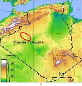 Location of the Ougarta Range in Algeria
| |
| Highest point | |
| Peak | Djebel Bet Touaris |
| Elevation | 890 m (2,920 ft) |
| Dimensions | |
| Length | 250 km (160 mi) northwest-southeast |
| Width | 50 km (31 mi) |
| Geography | |
| Country | Algeria |
| Province | Béchar Province |
| Range coordinates | 29°36′N 2°21′W / 29.600°N 2.350°WCoordinates: 29°36′N 2°21′W / 29.600°N 2.350°W |
Ougarta Range or Mountains of Ougarta (Arabic: سلاسل الوقارتة, French: Chaînes d'Ougarta) are a mountain range in the Saoura area of southwestern Algeria. The range is oriented from northwest to southeast, and extends over a length of 250 kilometres (160 mi) to a maximum width of 50 kilometres (31 mi).[1]
The highest point of the Ougarta Range is Djebel Bet Touaris (elevation 890 m),[2] located in the extreme northwest of the chain. The other major peaks are Djebel Rhemouma (867 m) and Djebel Berga Saida (855 m), both located in the northwest.
The remaining peaks have an altitude between 772 m (northwest) and 602 m (southeast).
The Ougarta Range is surrounded:
- to the northeast by the Grand Erg Occidental (the valley of Oued Saoura is the boundary between the two geographical areas);
- to the northwest by the Erg Er Raoui.
The Ougarta Range is named after the village and oasis of Ougarta, which lies amongst the mountains. Other towns lying next to the range are the village of Zerhamra in the northwest, and Béni Ikhlef and Kerzaz in the southeast.
References
- ↑ Fernand Joly, Yvette Dewolf, Pierre Freytet, André Simonin, Gabriel Rougerie, Les monts d'Ougarta, 1991
- ↑ Carte IGN, Béchar NH-30, 1/1000000, 1968.
| Tell Atlas |
|
|---|---|
| Saharan Atlas |
|
| Saharan massifs | |
| Peaks |
|