Amour Range
| Amour Range | |
|---|---|
| جبال العمور | |
 Neolithic art in Aflou | |
| Highest point | |
| Peak | Djebel Ksel |
| Elevation | 2,008 m (6,588 ft) [1] |
| Coordinates | 34°03′0″N 2°04′0″E / 34.05000°N 2.06667°ECoordinates: 34°03′0″N 2°04′0″E / 34.05000°N 2.06667°E [2] |
| Dimensions | |
| Length | 130 km (81 mi) ENE/WSW |
| Width | 40 km (25 mi) NNW/SSE |
| Area | 7,710 km2 (2,980 sq mi) |
| Geography | |
 Amour Range | |
| Parent range | Saharan Atlas |
| Geology | |
| Orogeny | Alpine orogeny |
The Amour Range (Arabic: جبل العمور, French: Djebel Amour) is a mountain range in Algeria, which comprises part of the Saharan Atlas of the Atlas Mountain System.
Geography
The Amour Range is located in the central area of the Saharan Atlas, with the Ksour Range in the western end and the Ouled-Naïl Range in the eastern end.[3]
The town of Aflou, one of the highest municipalities in Algeria and also one of the coldest, is located in the range at an elevation of 1,426 m. There are about 35,000 people living in the area of the Amour Range.[4] In Taouïala (تاوياله), located 35 km to the southeast of Aflou, there is an ecotouristic village.[5]
Peaks
The mountains of the Amour Range have altitudes averaging between 1,400 and 2000 m. The highest summit of the range is Djebel Ksel, which sits at an elevation of 2,008 m.
Other notable peaks are:[6]
- 1,721 m high Guern Arif (جبل قرن عريف)
- 1,707 m high Mount Sidi Okba (جبل سيدي عقبة)
- 1,706 m high Mount Gourou (جبل قورو)
- 1,686 m high Oum El Guedour (أم القدور)
- 1,503 m high Kef Sidi Bouzid (كاف سيدي بوزيد).
See also
References
- ↑ G. Camps, « Amour (djebel) », in Encyclopédie berbère, 4 | Alger – Amzwar En ligne, mis en ligne le 1er décembre 2012, consulté le 14 décembre 2014.
- ↑ Google Earth
- ↑ Un gisement d'ostracodes non-marins dans l'Éocène inférieur du Djebel Amour, Atlas saharien central, Algérie
- ↑ Le Djebel Amour
- ↑ Village éco-touristique solidaire à Taouiala wilaya de Laghouat
- ↑ Le Djebel Amour, Relief, Géologie et hydrogéologie
External links

- Despois (J.), Le djebel Amour (Algérie), 1957
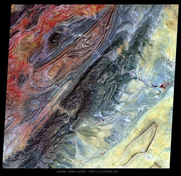
- "First image Spot-1: Dejbel Amour". 23 February 1986. Archived from the original on 15 April 2014.
- A. Bernard, Les régions naturelles de l'Algérie
- Taouïala
| Tell Atlas |
|
|---|---|
| Saharan Atlas |
|
| Saharan massifs | |
| Peaks |
|