Tamanrasset Province
| Tamanrasset Province ولاية تمنراست | |
|---|---|
| Province | |
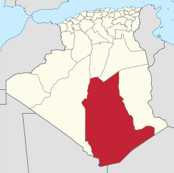 Map of Algeria highlighting Tamanrasset | |
| Coordinates: 22°47′N 05°31′E / 22.783°N 5.517°ECoordinates: 22°47′N 05°31′E / 22.783°N 5.517°E | |
| Country |
|
| Capital | Tamanrasset |
| Area | |
| • Total | 556,200 km2 (214,800 sq mi) |
| Population (2008)[1] | |
| • Total | 198,691 |
| • Density | 0.36/km2 (0.93/sq mi) |
| Time zone | UTC+01 (CET) |
| Area Code | +213 (0) 29 |
| ISO 3166 code | DZ-11 |
| Districts | 7 |
| Municipalities | 10 |
Tamanrasset or Tamanghasset (Arabic: ولاية تمنراست) is the largest province (wilaya) in Algeria. It was named after its province seat, Tamanrasset. The province has two national parks, more than any other in Algeria. They are Tassili n'Ajjer National Park and Ahaggar National Park. The province makes up almost a quarter of the country's area with 556,200 km².
Administrative divisions
The province is divided into 7 districts (daïras),[2] which are further divided into 10 communes or municipalities.
Districts
Communes
See also
References
- ↑ Office National des Statistiques, Recensement General de la Population et de l’Habitat 2008 Archived 2008-07-24 at the Wayback Machine. Preliminary results of the 2008 population census. Accessed on 2008-07-02.
- ↑ "The official journal of People's Democratic Republic of Algeria" (PDF). SGG Algeria. Retrieved 2007-11-06.
| Tamanrasset District |  | |||||
|---|---|---|---|---|---|---|
| In Salah District | ||||||
| Tazrouk District | ||||||
| Abalessa District | ||||||
| In Ghar District | ||||||
| Tin Zaouatine District | ||||||
| In Guezzam District | ||||||
| ||
This article is issued from
Wikipedia.
The text is licensed under Creative Commons - Attribution - Sharealike.
Additional terms may apply for the media files.