Wadi
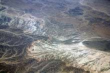
Wadi (Arabic: وَادِي, translit. wādī), alternatively wād (Arabic: وَاد), is the Arabic term traditionally referring to a valley. In some instances, it may refer to a dry (ephemeral) riverbed that contains water only during times of heavy rain.
Etymology
The term wādī is very widely found in Arabic toponyms. Some Spanish toponyms are derived from Andalusian Arabic where wādī was used to mean a permanent river, for example: Guadalcanal from wādī al-qanāl (Arabic: وَادِي الْـقَـنَـال, "river of refreshment stalls"), Guadalajara from wādī al-ḥijārah (Arabic: وَادِي الْـحِـجَـارَة, "river of stones"),[1] or Guadalquivir, from al-wādī al-kabīr (Arabic: اَلْـوَادِي الْـكَـبِـيـر, "the great river").
General morphology and processes
Wadis are located on the gently sloping, nearly flat parts of deserts; commonly they begin on the distal portions of fans and extend to inland sabkhas or playas. In basin and range topography, wadis trend along basin axes at the terminus of fans. Permanent channels do not exist, due to lack of continual water flow. Wadi show braided stream patterns because of the deficiency of water and the abundance of sediments. Water percolates down into the stream bed causing abrupt loss in energy and resulting vast deposition. Wadis may develop dams of sediment which results in change of stream patterns in the next flash flood.
Wind also plays its role in deposition. When wadi sediments are underwater or moist, wind sediments are deposited over them. Thus wadi sediments contain both wind and water sediments.
Sediments and sedimentary structures
Wadi sediments may contain whole range from gravel to mud. There is also wide range of sedimentary structures. Thus, wadi sediments are most diagnostic of all other desert environments.
Flash floods represent severe energy conditions and results in wide range of sedimentary structures, including ripples and commonly plane beds. Gravels common display imbrications, Mud drapes show desiccation cracks. Wind activity also generates its own sedimentary structures, large scales cross-stratification and wedge shape cross-sets are present. Typical wadi sequence consists of alternating units of wind and water sediments; each unit range about 10–30 cm (3.9–11.8 in). Water laid sediments show complete fining upward sequence. Gravels show imbrication. Wind deposits are cross stratified and covered with mud-cracked deposits. Some horizontal Loess may also present.
Hydrological action

Modern English usage differentiates a wadi from another canyon or wash by the action and prevalence of water. Wadis, as drainage courses, are formed by water, but are distinguished from river valleys or gullies in that surface water is intermittent or ephemeral. Wadis are generally dry year round, except after a rain. The desert environment is characterized by sudden but infrequent heavy rainfall, often resulting in flash floods. Crossing wadis at certain times of the year can be dangerous as a result.
Wadis tend to be associated with centers of human population because sub-surface water is sometimes available in them. Nomadic and pastoral desert peoples will rely on seasonal vegetation found in wadis, even in regions as dry as the Sahara, as they travel in complex transhumance routes.
The centrality of wadis to water — and human life — in desert environments gave birth to the distinct sub-field of wadi hydrology in the 1990s.[2]
Deposits
Deposition in a wadi is rapid because of the sudden loss of stream velocity and seepage of water into the porous sediment. Wadi deposits are thus usually poorly sorted gravels and sands. These sediments are often reworked by eolian processes.[3]
Over time, wadi deposits may become "Inverted Wadis" where the presence at one time of underground water caused vegetation and sediment to fill in the wadi's eroded channel, to the point that previous washes appear as ridges running through desert regions.
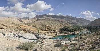
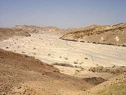
Gallery

.jpg)
See also
References
- ↑ Ayuntamiento de Guadalajara, Guadalajara tourist guide, p.5. Archived 1 July 2012 at the Wayback Machine., retrieved 17 August 2013
- ↑ Review of Wheater, Howard ; Al Weshah, Radwan, Hydrology of Wadi systems -IHP Regional Network on Wadi Hydrology in the Arab Region, UNESCO - Technical documents in hydrology vol 55, SC.2002/WS/33,(2002).
- ↑ Achite, Mohamed; Ouillon, Sylvain (September 2007). "Suspended sediment transport in a semiarid watershed, Wadi Abd, Algeria (1973–1995)". Journal of Hydrology. 343 (3–4): 187–202. doi:10.1016/j.jhydrol.2007.06.026.
- ↑ Alimsk (2013-12-20). "Wadi Bani Khalid & Wadi Hawer". Oman Tripper. Retrieved 2018-03-25.
- ↑ Pedro. "Visiting Wadi Bani Khalid, Oman: A Desert Paradise". Travel With Pedro. Retrieved 2018-03-25.
Bibliography
- Summary: Drainage Courses, Wadis. United States Army Corps of Engineers. Desert Processes Working Group; Knowledge Sciences, Inc. (n.d), retrieved 2008-08-26.
- Summary: Summary: Drainage Courses, Wadis - Inverted. United States Army Corps of Engineers. Desert Processes Working Group; Knowledge Sciences, Inc. (n.d), retrieved 2008-08-2onments
- Gelennie, K. W., 1970 Deserts sedimentary Environments. Developments in Sedimentology, v.14. Elsevier, Amsterdam, 222p.
External links
| Wikimedia Commons has media related to Wadis. |
| Look up wadi in Wiktionary, the free dictionary. |