Dalola Union Council
| Dalola | |
|---|---|
| Union Council | |
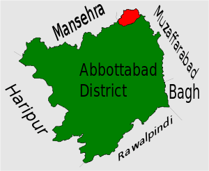 Location of Dalola Union Council (highlighted in red) within Abbottabad district, the names of the neighbouring districts to Abbottabad are also shown. | |
| Coordinates: 34°21′20″N 73°23′50″E / 34.35556°N 73.39722°E | |
| Country |
|
| Province | Khyber-Pakhtunkhwa |
| District | Abbottabad |
| Tehsil | Abbottabad[1] |
| Population | |
| • Total | 18,900 |
Dalola is one of the 51 union councils (sub-divisions) of Abbottabad District in Khyber-Pakhtunkhwa province of Pakistan.[2]
Location
Dalola is located at 34°21'20N 73°23'50E and has an average elevation of 798 metres (2621 ft).[3] Dalola is the most north-eastern part of the district, it borders U.C Karnol & Garhi Habibullah of Mansehra District to the north and the River Kunhar and Muzaffarabad District of Kashmir to the east. To the south lies U.C Boi and to the west situated Tarnawai (U.C Banda Pir Khan). It was hit quite badly by the 2005 Pakistan earthquake.
Subdivisions
The Union Council is subdivided into the following areas:
- (( Malik Ghulam Ali Khan Town
Awan Abad ))
- ((Hoter Awanabad sector 2))
- ((Batangaw Awanabad sector 3))
- ((Gran Awanabad sector 4))
- (( sehri))
- (( pindhi)
- ((kachar))
- (( kalgran))
- ((Darrah))
- ((dhora))
- ((Dabban))
- ((Dalola))
- ((Naroka))
- ((Mujffah))
- ((Dogranina))
- Sirla / Hadora
History
Dalola is named after Sikh which indicates Sikh presence in the area during early 19th century. However their presence was nominal as all the surrounding hills were occupied by Muslim tribes. When Sikh lost their territories all our Hazara and Punjab during Anglo Sikh war (1845–46) they were either killed by hill tribes or narrowly escaped from their persecution. These tribes captured and divided lands among themselves and which they still hold. During British rule the area remain semi independent paying revenue like rest of Hazara tribes and despite many attempts by Khan of Garhi and Sultan of Boi to capture Dalola. Tribes of dalola fight with British (hindu & Sikh) and they win after that they fight with Khan of Garhi and Sultan of Boi both wants to capture Dalola but they didn't success.it was never subdued or came under their influence.
Tribes
Main tribes residing in Dalola are Dhund Abbasi Awan and Malik. There are also some other tribes are [Karlal], [Satti] with few Syed. [[Kashmiris [Sarrara,(Qureshi)], [Raja] families and also some village artisans and menials. Abbasi tribe is further subdivided into Meriwal, Charwal, Tatial )and Awan's subtribe is Bagwal,Alvi,malik, khan. Nearby villages are Awanabad ( Malik Gulam Ali Khan town) Mujafa, Hadora, Dara, Daban, Garang, Sehali,Hoter (Awanabad sector 2) Pindi, Burj, Bai (Mohallah Sardar Pir Khan) Bholu di Seri,Gran (Awanabad sector 3) Batangan(Abbasi family), Islampura, Danna, Gali Malkhan (Malik abbasi family),Changli (satti tribe) and many more.
Famous Personalities
The Most famous personalites (late Sardar Pir Khan). Nambardar Malik Gulam Ali Khan ( tiger of Awans) Gohr Rehman Abbasi Ex EDO Abbottabad Maj General R Tariq Abbasi , Col Talat iqbal khan (Army officer GHQ) Maj Kawar abbasi(Army Officer ISPR,GHQ) Maj shafqat Abbasi(Army officer),Arshid Abbasi(PMS officer) Haji Sarwar Abbasi Leader PMLN Dalola M Professor Hanif Abbasi Leader PMLN Dalola Akram Khan Abbasi Leader Jamiat UL Ulama e Islam F & EX Candidate PK 45 Malik Zaheer Abbasi District member UC Dalola Malik Mubarak Abbasi Leader PTI Dalola Sabar Abbasi PMLN Hadora Molana Abdullah Abbasi Tehsil Member Qazi Shafiq UR Rehman Abdul Qayyum ex Principal GHS Dalola Fayaz sb ex Principal GHS Dalola Arshad Abbasi Garang VC Chairman Parvez Abbasi Shaeed Sehali Sardar Abdul Qayyum Abbasi Hadora (L) Haji Abdul Ghani Abbasi (L) Muhammad Riaz Abbasi PMLN
Babar Abbasi (Mechanical Engineer) Jamat e islami Pk.45 Shaukat Ali Abbasi Leader Jamiat UL ulama e Islam F. Malik Fateh khan Awan (late)Nambardar Garan wala. Malik Mohammad Iqbal khan Awan, Malik Khushal Khan Awan, Mohammad Mubarrak awan (Late) HBL.
Coordinates: 34°21′20″N 73°23′50″E / 34.35556°N 73.39722°E