Mohmand District
| Mohmand District مومند | |
|---|---|
| District | |
 | |
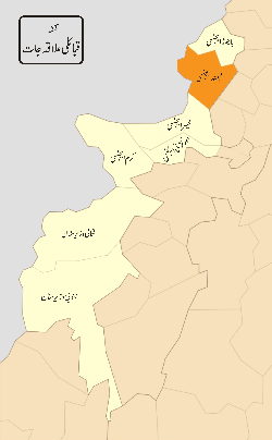 District map of FATA and Khyber-Pakhtunkhwa. Districts of FATA are shown in orange, and the Mohmand Agency is located in the north. | |
| Country | Pakistan |
| Province | Khyber Pakhtunkhwa |
| Established | 1951 (as an agency of Federally Administered Tribal Areas) |
| Headquarters | Ghalanai |
| Number of Tehsils | 7 |
| Government | |
| • Political Agent | Mr. Muhammad Wasif Saeed (PAS) |
| Area | |
| • Total | 2,296 km2 (886 sq mi) |
| Population (2017)[1] | |
| • Total | 466,984 |
| • Density | 200/km2 (530/sq mi) |
| Time zone | UTC+5 (PST) |
| Main language(s) | Pashto (99.8%)[2] |
Mohmand (Pashto: د مومندو سيمه; Urdu: ضلع مہمند) is a district of Khyber Pakhtunkhwa, Pakistan. Until 2018, it was an agency of Federally Administered Tribal Areas, with merger of FATA with Khyber Pakhtunkhwa, it became a district. It was created as an agency in 1951. Mohmand is bordered by Bajaur District to the north, Khyber District to the south, Malakand and Charsadda districts to the east and Peshawer district to the south east.
Muhammad Wasif Saeed (PAS) was posted as political agent of Mohmand Agency on 6 April 2018.[3]
Administration
Mohmand District is currently subdivided into seven tehsils:[1]
Population
The current population of Mohmand Agency is 466,984 as per the report,[4] with an annual growth rate of 1.77. The population was 334,453 as per the 1998 Census.
War on Terror
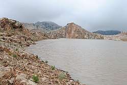
Despite its attraction for tourists, Mohmand Agency has been an area of conflict between Pakistan Army and some militant groups. In a recent exchange of fire between the two, the media reported that at least 18 militants were killed and 25 others were injured.[5]
On September 16, 2011, security forces cleared ninety percent of Mohmand Agency from the militants, normal life was restored and development activities were launched.[6] The Pakistan Army maintains an 8,200-man presence in Mohmand Agency following military operations to clear the region of militants.[7]
In 2012, the Pakistani Army declared full control of Mohmand agency and de-notified it as a conflict zone.[8]
References
- 1 2 "DISTRICT AND TEHSIL LEVEL POPULATION SUMMARY WITH REGION BREAKUP [PDF]" (PDF). www.pbscensus.gov.pk. 2018-01-03. Retrieved 2018-03-25.
- ↑ 1998 Census report of Mohmand Agency. Census publication. 139. Islamabad: Population Census Organization, Statistics Division, Government of Pakistan. 2001. p. 20.
- ↑ "Pakistan suicide bomb attack kills dozens". BBC News. London, UK. 2010-12-06.
- ↑
- ↑ Fida, Noman (2011-04-14). "Forces Kill 18 militants in Mohmand Agency". The News Tribe. Bradford, UK.
- ↑ "90% of Mohmand Agency cleared of militants; IDPs return home". The Nation. Lahore, Pakistan: Nawa-i-Waqt. 2011-09-16. Archived from the original on 2011-09-28. Retrieved 2018-04-09.
- ↑ Hosain, Quatrina (2011-11-30). "'Unprovoked': DGMO gives details of aerial assault". The Express Tribune. Karachi, Pakistan.
- ↑ Ali, Zulfiqar (2012-08-06). "South Waziristan operation: Only Sararogha cleared in three years". Dawn. Karachi, Pakistan: Pakistan Herald Publications.
| Agencies |  | |
|---|---|---|
| Frontier Regions | ||