Hattfjelldal
| Hattfjelldal kommune | |||
|---|---|---|---|
| Municipality | |||
 View of Hattfjell ("hat mountain") | |||
| |||
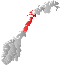
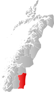 Hattfjelldal within Nordland | |||
| Coordinates: 65°32′51″N 14°08′04″E / 65.54750°N 14.13444°ECoordinates: 65°32′51″N 14°08′04″E / 65.54750°N 14.13444°E | |||
| Country | Norway | ||
| County | Nordland | ||
| District | Helgeland | ||
| Established | 1862 | ||
| Administrative centre | Hattfjelldal | ||
| Government | |||
| • Mayor (2015) | Harald Lie (Sp) | ||
| Area | |||
| • Total | 2,684.31 km2 (1,036.42 sq mi) | ||
| • Land | 2,413.45 km2 (931.84 sq mi) | ||
| • Water | 270.86 km2 (104.58 sq mi) | ||
| Area rank | #17 in Norway | ||
| Population (2017) | |||
| • Total | 1,414 | ||
| • Rank | #357 in Norway | ||
| • Density | 0.6/km2 (2/sq mi) | ||
| • Change (10 years) | -4.6% | ||
| Demonym(s) | Hattfjelldaling[1] | ||
| Time zone | UTC+01:00 (CET) | ||
| • Summer (DST) | UTC+02:00 (CEST) | ||
| ISO 3166 code | NO-1826 | ||
| Official language form | Neutral | ||
| Website |
hattfjelldal | ||
Hattfjelldal (Southern Sami: Aarborte and Northern Sami: Árbordi) is a municipality in Nordland county, Norway. It is part of the Helgeland traditional region. The administrative centre of the municipality is the village of Hattfjelldal. Other villages include Grubben, Svenskvollen, and Varntresk. Hattfjelldal Airfield is located in the village of Hattfjelldal.
The 2,684-square-kilometre (1,036 sq mi) municipality is the 17th largest by area out of the 422 municipalities in Norway. Hattfjelldal is the 357th most populous municipality in Norway with a population of 1,414. The municipality's population density is 0.6 inhabitants per square kilometre (1.6/sq mi) and its population has decreased by 4.6% over the last decade.[2]
Hattfjelldal is one of the last strongholds for the seriously endangered Southern Sami language. It was also one of the municipalities in Norway involved in the Terra Securities scandal.
General information
The municipality of Hattfjelldal was established in 1862 when it was separated from the large municipality of Vefsn. The initial population of Hattfjelldal was 961. On 1 January 1964, the part of Hattfjelldal on the north side of the lake Røssvatnet (population: 168) was transferred to Hemnes.[3]
Name
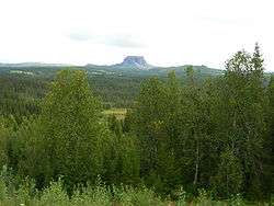
The municipality (originally a parish) is named after the old Hattfjelldalen farm (referred to as "Hatfieldalen" in 1723) where the first church was built. The name describes the valley (-dalen) below the mountain Hattfjellet. Hattfjellet takes its name from the hat-like shape.[4]
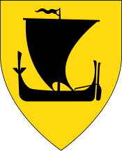
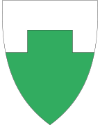
Coat-of-arms
The coat-of-arms is from modern times; it was granted on 24 October 1986. The arms show the Hattfjellet mountain, with its typical shape. The mountain is a canting element since the name of the municipality means "hat mountain valley".[5]
Churches
The Church of Norway has one parish (sokn) within the municipality of Hattfjelldal. It is part of the Indre Helgeland prosti (deanery) in the Diocese of Sør-Hålogaland.
| Parish (Sokn) | Church Name | Location of the Church | Year Built |
|---|---|---|---|
| Hattfjelldal | Hattfjelldal Church | Hattfjelldal | 1868 |
| Susendal Church | Svenskvollen | 2001 | |
| Varntresk Church | Varntresk | 1986 |
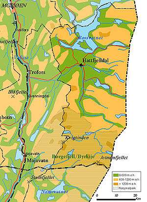
Geography
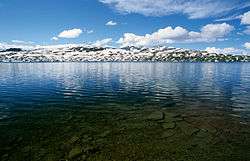
Hattfjelldal lies along the Swedish border in the southeastern part of Nordland county. The lake Røssvatnet (Southern Sami: Reevhtse) lies on the border between Hattfjelldal and Hemnes, and it serves as a reservoir. It has been the site of human occupation since the Stone Age. Its area of 219 square kilometres (85 sq mi) makes it the second largest lake in Norway by surface area.
Other lakes in the region include Daningen, Elsvatnet, Famnvatnet, Jengelvatnet, Kjerringvatnet, Krutvatnet, Ranseren, Simskardvatnet, and Unkervatnet. The large river Vefsna runs through the municipality.
Børgefjell National Park is partly located in the southern part of Hattfjelldal, as is Jetnamsklumpen, a prominent mountain. There is several nature reserves, such as Varnvassdalen with a varied topography and old growth forest of pine, birch and some spruce.[6]
Government
All municipalities in Norway, including Hattfjelldal, are responsible for primary education (through 10th grade), outpatient health services, senior citizen services, unemployment and other social services, zoning, economic development, and municipal roads. The municipality is governed by a municipal council of elected representatives, which in turn elect a mayor.
Municipal council
The municipal council (Kommunestyre) of Hattfjelldal is made up of 17 representatives that are elected to four year terms. Currently, the party breakdown is as follows:[7]
| Party Name | Name in Norwegian | Number of representatives | |
|---|---|---|---|
| Labour Party | Arbeiderpartiet | 7 | |
| Centre Party | Senterpartiet | 6 | |
| Socialist Left Party | Sosialistisk Venstreparti | 1 | |
| Local Lists | Lokale lister | 3 | |
| Total number of members: | 17 | ||
References
- ↑ "Navn på steder og personer: Innbyggjarnamn" (in Norwegian). Språkrådet. Retrieved 2015-12-01.
- ↑ Statistisk sentralbyrå (2017). "Table: 06913: Population 1 January and population changes during the calendar year (M)" (in Norwegian). Retrieved 2017-09-16.
- ↑ Jukvam, Dag (1999). "Historisk oversikt over endringer i kommune- og fylkesinndelingen" (PDF) (in Norwegian). Statistisk sentralbyrå.
- ↑ Rygh, Oluf (1905). Norske gaardnavne: Nordlands amt (in Norwegian) (16 ed.). Kristiania, Norge: W. C. Fabritius & sønners bogtrykkeri. p. 86.
- ↑ Norske Kommunevåpen (1990). "Nye kommunevåbener i Norden". Retrieved 2008-11-23.
- ↑ "Varnvassdalen naturreservat" (in Norwegian). Retrieved 2008-11-23.
- ↑ "Table: 04813: Members of the local councils, by party/electoral list at the Municipal Council election (M)" (in Norwegian). Statistics Norway. 2015.
External links
- Municipal fact sheet from Statistics Norway (in Norwegian)
| Wikimedia Commons has media related to Hattfjelldal. |

| |||||||||||||||||
| |||||||||||||||||