A roads in Zone 3 of the Great Britain numbering scheme
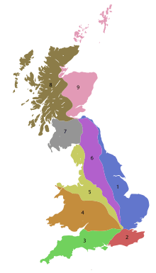
The numbering zones for A-roads in Great Britain
List of A roads in zone 3 in Great Britain starting west of the A3 and south of the A4 (roads beginning with 3).
Single- and double-digit roads
| Road | From | To | Notes |
|---|---|---|---|
| The Monument, London | Portsmouth | A large majority is a trunk road. Its southern parallel motorway is designated the A3(M). | |
| Hounslow, West London | Land's End | Replaced for 6 miles (9.7 km) between Popham and the Bullington interchange by the A303 trunk road southwest of Basingstoke. A trunk road west of Exeter. | |
| Guildford | Bere Regis | Near the M3 its Romsey and Winchester portion is replaced by: • the J10 to J11, M3, Winchester • The A3090 from J11 to Ower in the New Forest District — a winding route covering 11 miles (18 km) in 16 miles (26 km). | |
| Gosport | Alton | All in Hampshire | |
| Winchester | Reading | Resumes in Southampton as various roads such as the arterial road alongside Southampton Dock. | |
| Winchester | Salford | Most of the section between Oxford and Solihull is arguably the A44 and the A3400 however its modern course ends northeast to join the M40 from which the northern part of the road can be accessed after one junction of the M42 motorway. A trunk road to Oxford and between Stafford and Stoke on Trent. | |
| Southampton | Honiton | ||
| Southampton | Bath | ||
| Dorchester | Bristol | Broken in two past the former Roman town of Ilchester by a bypass which is a small fraction of the A303 | |
| Bodmin | Mansfield | Replaced by J27 to J31, M5. In Birmingham a shorter parallel road into the city centre is the A38(M) motorway A dual carriageway in South Devon, Staffordshire and Derbyshire. | |
| Newton Park near Bath | Falmouth |
Triple-digit roads
Four-digit roads (30xx)
Four-digit roads (31xx and higher)
| Road | From | To | Notes | |
|---|---|---|---|---|
| Burpham | Milford | Formerly the A3 | ||
| Swindon | Royal Wootton Bassett, Calne, Melksham | |||
| Parting Carn, St Mary's | Maypole | Circular road on St Mary's island | ||
| The Quay, Hugh Town, St Mary's | Parting Carn | The most westerly classified road in England | ||
| The Parade, Hugh Town, St Mary's | Parting Carn/St Mary's Airport | The most southerly classified road in the United Kingdom | ||
| M25 motorway Junction 14 | Heathrow Airport | |||
| Wrangaton | Ermington | Formerly B3211 | ||
| Halwell | Dartmouth | Formerly part of B3207 | ||
| Combe Martin | Ilfracombe | Formerly part of B3343 | ||
| Whiddon Down, Drewsteignton | Great Torrington | Formerly part of B3220 and unclassified roads | ||
| Barnstaple | Barnstaple | Formerly part of A39 | ||
| Tiverton | Tiverton | Formerly part of A396 | ||
| London Bridge | County Hall | Southwark Street/Stamford Street/York Road | ||
| A300 Southwark Bridge Road | The Borough | Marshalsea Road | ||
| Lambeth North station | The Borough | |||
| Lambeth Bridge | St George's Circus | |||
| Elephant & Castle | Vauxhall Cross | Kennington Lane, part of the London Inner Ring Road | ||
| Vauxhall | Battersea | In the London Borough of Lambeth: Nine Elms Lane; in the London Borough of Wandsworth: Nine Elms Lane, Battersea Park Road | ||
| A3207 road | York Road, Battersea | Lavender Hill, Battersea | Falcon Road | |
| Wandsworth | Putney Bridge | |||
| A240 in Surbiton | A243 in Surbiton | Short link road | ||
| Westminster | Tower of London | |||
| Trafalgar Square | Chelsea | Whitehall, then Millbank and following the north of the Thames along the Chelsea Embankment to Battersea Bridge. The Houses Of Parliament are on this road. | ||
| Pimlico | Eaton Square | |||
| Buckingham Palace | Royal Hospital Chelsea | |||
| Knightsbridge | Clapham Common | In the City of Westminster: Sloane Street, Sloane Square, Chelsea Bridge Road, Chelsea Bridge; in the London Borough of Wandsworth: Chelsea Bridge, Queenstown Road (including Queen's Circus); in the London Borough of Lambeth: Queenstown Road, Cedars Road | ||
| Victoria | Chelsea | |||
| South Kensington | Fulham | Old Brompton Road, Lillie Road | ||
| Fulham | Fulham | Dawes Road | ||
| Clapham Common | White City | |||
| Staplegrove | Monkton Heathfield | Formerly part of A361 | ||
| Winnersh | Reading | Previously the northern section of the A329(M) | ||
| Hockley Heath | Near Chipping Norton | Formerly part of A34 | ||
| Bath | Bath | |||
| A3807 road | A38 in Taunton | A3027 in Taunton |
Notes and references
| Wikimedia Commons has media related to A roads in Zone 3 of the Great Britain numbering scheme. |
- Notes
- ↑ northeast of Camelford
- ↑ west of Launceston
- References
- ↑ See File:OS_Heathrow_5th_Edition.jpg
This article is issued from
Wikipedia.
The text is licensed under Creative Commons - Attribution - Sharealike.
Additional terms may apply for the media files.