Whitton, London
| Whitton | |
|---|---|
 The High Steet | |
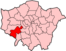
 Whitton Whitton shown within Greater London | |
| Area | 3.56 km2 (1.37 sq mi) |
| Population | 20,065 (2011 Census Heathfield+Whitton 2011)[1][2] |
| • Density | 5,636/km2 (14,600/sq mi) |
| OS grid reference | TQ145735 |
| London borough | |
| Ceremonial county | Greater London |
| Region | |
| Country | England |
| Sovereign state | United Kingdom |
| Post town | TWICKENHAM, HOUNSLOW, ISLEWORTH |
| Postcode district | TW2,TW3,TW4,TW7 |
| Dialling code | 020 |
| Police | Metropolitan |
| Fire | London |
| Ambulance | London |
| EU Parliament | London |
| UK Parliament | |
| London Assembly | |
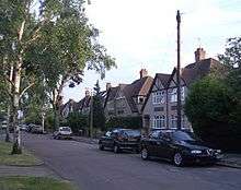
Whitton is a leafy suburban area in the London Borough of Richmond upon Thames. It forms the western part of Twickenham and is located in Southwest London. It has a railway station on the Windsor Line from London Waterloo and has good road links with the A316 running through the area that leads to the M3 motorway. The focus of the district is the High Street which is one of the best-preserved 1930s high streets in London. The most common type of housing in the area is 1930's detached and semi-detached housing. As a mainly residential area in outer London, many residents commute to Central London; education, retail, transport and catering businesses are also significant local employers.
History
Formally part of the ancient parish of Twickenham until 1862 when it became a separate parish with the church of St Philip and St James opening that year. Due to rapid development the parish was divided again in the 1958 and the two electoral wards that make up the town still broadly follow these two parish boundaries.
Bronze Age
In 1999, excavations on the former Feltham marshalling yard, located on the western border of Whitton, unearthed remains of an Iron Age furnace and post holes from a round house. There are various remains of former mills and other industrial archaeological features adjoining the River Crane and this part of the river is classified as an Archaeological Priority Area [3]
Norman
In Norman times Whitton was the western rural part of Twickenham which was in turn part of the Manor of Isleworth – itself part of the subdivision of the ancient county of Middlesex, England. The manor had belonged to Ælfgar, Earl of Mercia[4] in the time of Edward the Confessor, but was granted to Walter de Saint-Valery (Waleric) by William I of England after the Norman Conquest of England in 1066.
Tudor
Around 1540 gunpowder started to be produced along the River Crane in what was to become known as the Hounslow Gunpowder Mills [5] as it was sited on part of Hounslow Heath which at the time covered a large part of Twickenham. The site was chosen in part as it was away from built up areas, lessening the impact of accidental explosions.
By the 16th century the area that was to become Whitton started to see large houses being developed, as the fashionable society in Twickenham started to spread outward. The Elizabethan and Jacobean courtier Sir John Suckling built a house in the vicinity of the present Murray Park (his son the poet Sir John Suckling was born in Whitton in 1609). Sir John later replaced his first house with a grander residence on land adjoining today's Warren Road.
Stuart
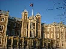
Around 1640 Edmund Cooke built a large house close to the centre of the village. This was later bought by the court painter Sir Godfrey Kneller who pulled it down and in 1709 erected his own larger house. This in turn was considerably modified by later owners and was eventually acquired by the state in 1847 for use as a teacher training college and is now home to the Royal Military School of Music.
At the centre of the original village, about 200 m from Kneller Hall is the White Hart, an inn dating back at least to the mid-17th century and possibly much earlier. Records relating to this inn seem to suggest that Whitton had an importance that was not well recorded, or that travellers passed through it in considerable numbers. A document of 1685 shows that it provided three beds, and stabling for ten horses; numbers which did not seem to fit with Whitton's apparent status as a sleepy rural hamlet with only a few dozen inhabitants.
Georgian
At the northern end of Whitton was Whitton Park, the estate of the third Duke of Argyll, which he established in 1722 on land that had been enclosed some years earlier from Hounslow Heath. The Duke was an enthusiastic gardener and he imported large numbers of exotic species of plants and trees for his estate; he had professional advice from the Scottish gardener James Lee (1715–1795). After the Duke's death his nephew, the third Earl of Bute, moved many of these, including mature trees, to the Princess of Wales' new garden at Kew.[6] This later became Kew Gardens and some of the Duke's trees can still be seen there to this day.
Victorian
Whitton was renowned as a 'market garden', known for its roses, narcissi, lilies of the valley and for its apple, plum and pear orchards. Indeed, until the 1920s the village was still separated from the surrounding towns by open fields and much of the earlier character of the old village was retained well into the 1940s. However, in little more than a decade all that changed.
The coming of the railways in 1850 started to prompt more development with the area initially served by Hounslow & Whitton railway station (later renamed Hounslow railway station) built by London and South Western Railway and opened on 1 February 1850.
Early 20th century
Although there was a little housing development in the 19th century, on Nelson and Hounslow Roads and in the area between Kneller and Nelson Roads, Whitton remained a quiet country village. However, following the opening of Whitton railway station in Percy Road in 1931, housing development rapidly replaced the market gardens and the former Argyll Estate, having been sold for development in the 1890s. New parades of shops were built on either side of Percy Road from the railway station bridge to the junction with Nelson and Hounslow Roads. This stretch then became known as "High Street" Whitton.

World War II
A number of houses were damaged by enemy bombing in the early years of the Second World War. Before 1944, 86 Hounslow Road received a direct hit from a German bomb and was badly damaged, though not destroyed. In June 1944, 81 High Street received a direct hit from a V1 flying bomb. Part of the parade of shops and the flats above was totally destroyed and several people were killed. Around the same time a house in Lincoln Avenue was also destroyed by a V1 and several adjoining houses were severely damaged.
There was certainly a great deal of activity in the skies over Whitton during the early years of the war with the sound of air raid sirens and anti-aircraft guns very common by both day and night. A common sight during the Blitz was of RAF fighters scrambling from nearby airfields almost at rooftop height and low enough for the pilots to be seen in their cockpits.
Economy

Most people travel outside of the town for their work as very little land is in employment use. Many people travel into Central London making use of the good transport connections, or work in nearby district centres such as Twickenham and Richmond or the bigger metropolitan centres such as Hounslow and Kingston upon Thames. London Heathrow Airport is important to the local economy both through direct employment and the cluster of international firms that have their European headquarters in the Thames Valley area.
The town centre is the third largest in the Richmond upon Thames.[7] In 2014 has received a £2 million programme of economic regeneration including new street lighting, yorkstone pavements[8] and a £5 million redevelopment of the railway station[9] was completed in December 2016.
Notable inhabitants
- Charles Calvert (1768–1832), brewer and Member of Parliament, lived at Kneller Hall[10]
- Sir Godfrey Kneller (1646–1723), portrait painter, built a house in 1709 in Whitton; its site is now occupied by the mid-19th century Kneller Hall, home of the Royal Military School of Music[11][12]
Leisure activities
With a third of the borough being green and open space – five times more than any other borough in London, Whitton [13] has much to offer in the way of leisure activities.
Parks and open spaces
The town has one long linear park along the River Crane and five smaller neighbourhood parks that have sport facilities and children's playgrounds along with three cemeteries. Close to the town are the large Bushy Park and Richmond Park that are managed by The Royal Parks and serve as the larger district parks for the area. Hounslow Heath, a large open space and local conservation area is heavily used by the towns residence, especially residents of the Hounslow Heath Estate.
- Hounslow Heath is located directly to the north of Whitton, with a small section in the town. It is one of the largest open spaces in West London.
- Chase Green is located between Redway Drive and Godfrey Avenue, next to Chertsey Road (A316) and is a registered Village Green.
- Crane Park, the largest nearby park, lies to the south on the London Loop walking route. It is managed as a number of wildlife habitats and is home to a number of protected species such as bats and kingfishers.
- Borough Cemetery along Powder Mill Lane and operated by London Borough of Hounslow
- Hounslow Heath Open Space is a fragment of the famous Hounslow Heath
- Hounslow Cemetery along Hanworth Road and operated by London Borough of Hounslow
- Heathfield Recreation Ground was opened in the 1930s and is laid out to accommodate sport pitches and a pavilion.
- Murray Park was opened in 1914 and is set out as grassland and children's playgrounds.
- Twickenham Cemetery
Cycling
Richmond is part of the London Cycle Network, offering on and off-road cycle paths throughout the area.
Leisure centres
The local authority operated Whitton Sports and Fitness Centre, based at the Twickenham Academy site, has a modern gym, sports hall and astroturf pitches. There are also three large commercial health clubs just over the town's boundary at The Stoop, Twickenham Golf Course and Twickenham Stadium.
Sport clubs
There are a number of sports clubs in Whitton including the Whitton Lions rugby club located at the Whitton Park Sports Association, and the Whitton Tennis Club based next to Kneller Hall.
Cinema
The Odeon cinema in the high street closed in December 1961[14] since then residents have had to travel to nearby towns such to visit the cinema. The local council has built a new arts centre in Twickenham which has a 300-seat auditoriam for dual theatre and cinema use. This is due to open in 2017 opposite Twickenham station but has not yet been formally named.[15]
Youth Centre
In September 2013, [16] Richmond Council opened a youth centre located behind Whitton High Street in Britannia Lane.
Heritage
With the Royal Court often staying in Richmond and Hampton Court in the eighteenth century, Twickenham was a very fashionable place to live and this has left the area with a unique cultural heritage. Many residents remember childhood outings to a number of important historical houses on the doorstep of Whitton including Ham House, Hampton Court Palace, Marble Hill House, Sion House and Strawberry Hill House. The only remaining country house left in Whitton is Kneller Hall which is now home to the Royal Military School of Music.
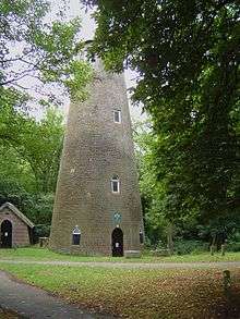
There is on only one Conservation Area in the area: Rosecroft Gardens. In addition there are a number of listed buildings such as Kneller Hall, the Shot Tower at Crane Park along with a number of locally listed buildings.
Education
There are six primary schools in the town with two of them being voluntary-aided faith schools – Bishop Perrin Church of England Primary (opened 1936) and St. Edmund's Roman Catholic Primary (opened 1938). Of the remaining four primary schools, three are maintained by the Local Authority – Heathfield Infants (opened 1931), Heathfield Junior and Chase Bridge Primary. The fourth, Nelson Primary (opened 1911), is an academy, part of the Latchmere Academy Trust.
The town has one secondary school, Twickenham Academy, which is part of the Richmond West Schools Trust.[17] There are plans to build a permanent home for Turing House School on Metropolitan Open Land at Hospital Bridge Road on the Bridge Farm Nursery site,[18] and a new school called The Richmond upon Thames School (RTS) will open in 2017 on part of the Richmond upon Thames College site just over the A316 in central Twickenham.[19] Some local children go to other Richmond Borough secondary schools, or to secondary schools in other boroughs. [20][21][22][23][24][25]
Churches
in 1862 Whitton separated from St Mary's, Twickenham[26] to become the parish of St Philip and St. James Whitton. In anticipation of this change Church of St Philip and St James (C of E) was built. In 1935, due to population growth, St Augustine of Canterbury, Whitton, was created as a London Diocesan Home Mission church in 1935, within the parish of St Philip and St Paul, and met in the main hall of Bishop Perrin School, Hospital Bridge Road. Later in 1958 it became the parish of 'St. Augustine Whitton' to coincide with the opening of new St Augustine's, Whitton that was opened further up Hospital Bridge Road.[27]
Whitton Methodist Church, in Percy Road, now shares its building with Calvary Chapel Twickenham, which is a Baptist church.
A non-conformist Gospel Hall was built in 1881 on the western side of Nelson Road a few metres to the north of the junction with Warren Road. This became redundant with the opening of Whitton Baptist Church in Hounslow Road in 1935 and was later used by various commercial enterprises. The building of Whitton Baptist Church was funded by the compensation paid for the compulsory purchase of St Margaret's Baptist Church, which was demolished during the construction of the Great Chertsey Road approach to the new Twickenham Bridge across the Thames in 1932. Another Baptist church, The Free Grace Baptist Church, was formed in 1964 and meets in a former Salvation Army Hall in Powder Mill Lane.
The Catholic Church of St Edmund of Canterbury is in Nelson Road and was opened in 1934 by the Edmundite Fathers (Society of Saint Edmund).[28] In 1988 the Edmundite Fathers left Whitton, since when the parish has been in the care of secular clergy.
Demography and housing
| Ward | Detached | Semi-detached | Terraced | Flats and apartments | Caravans/temporary/mobile homes/houseboats | Shared between households[2] |
|---|---|---|---|---|---|---|
| Whitton | 826 | 1,770 | 908 | 492 | 0 | 11 |
| Heathfield | 291 | 2.213 | 418 | 996 | 0 | 0 |
| Ward | Population | Households | % Owned outright | % Owned with a loan | hectares[2] |
|---|---|---|---|---|---|
| Whitton | 9,752 | 3,675 | 35 | 39 | 162 |
| Heathfield | 10,313 | 4,964 | 32 | 33 | 191 |
Transport
Roads
Whitton has good road links and is only a ten-minute car journey from the M25 in clear traffic. Journeys to Kingston upon Thames take twenty minutes, journeys to Hounslow take 5 minutes or 10 minutes by walk, whilst a journey to Richmond is ten minutes.
The A316 becomes the M3 at Sunbury-on-Thames and connects with the M25 at junction 2. Going the other direction the A316 passes by Twickenham town centre and then Richmond, Kew, Mortlake, and finally Chiswick where it joins The Great West Road A4.
Tube/Trains
The principal rail service from Whitton railway station is the Windsor Line into London Waterloo station taking 30 minutes on the ‘semi-fast’ service operated by South West Trains. There is also a ‘stopping’ service that calls at all stations and takes 40 minutes via Richmond, or 50 minutes via Brentford. Residents living in the north of the town use the closer Hounslow Station on the Hounslow Loop Line and Waterloo-Reading mainline.
As London Underground does not serve the Twickenham area, connections are often made at Richmond for the District line, or at Hounslow East for the Piccadilly Line. Plans to increase the frequency of the 'semi-fast' service to four trains per hour were first discussed in the Wessex Route Study consultation held in 2014 and are expected to be included in the new South Western franchise.[29] However, Richmond Council has requested these go via the Hounslow Loop and not Richmond due to concerns about the amount of time the level crossing would need to be down in Barnes.
Buses
London Buses serve Whitton:
Bus map | ||||||||||||||||||||||||||||||||||||||||||||||||||||||||||||||||||||||||||||||||||||||||||||||||||||||||||||||||||||||||||||||||||||||||||||||||||||||||||||||||||||||||||||||||||||||||||||||||||||||||||||||||||||||||||||||||||||||||||||
|---|---|---|---|---|---|---|---|---|---|---|---|---|---|---|---|---|---|---|---|---|---|---|---|---|---|---|---|---|---|---|---|---|---|---|---|---|---|---|---|---|---|---|---|---|---|---|---|---|---|---|---|---|---|---|---|---|---|---|---|---|---|---|---|---|---|---|---|---|---|---|---|---|---|---|---|---|---|---|---|---|---|---|---|---|---|---|---|---|---|---|---|---|---|---|---|---|---|---|---|---|---|---|---|---|---|---|---|---|---|---|---|---|---|---|---|---|---|---|---|---|---|---|---|---|---|---|---|---|---|---|---|---|---|---|---|---|---|---|---|---|---|---|---|---|---|---|---|---|---|---|---|---|---|---|---|---|---|---|---|---|---|---|---|---|---|---|---|---|---|---|---|---|---|---|---|---|---|---|---|---|---|---|---|---|---|---|---|---|---|---|---|---|---|---|---|---|---|---|---|---|---|---|---|---|---|---|---|---|---|---|---|---|---|---|---|---|---|---|---|---|---|---|---|---|---|---|---|---|---|---|---|---|---|---|---|---|
| ||||||||||||||||||||||||||||||||||||||||||||||||||||||||||||||||||||||||||||||||||||||||||||||||||||||||||||||||||||||||||||||||||||||||||||||||||||||||||||||||||||||||||||||||||||||||||||||||||||||||||||||||||||||||||||||||||||||||||||
Companies | ||||||||||||||||||||||||||||||||||||||||||||||||||||||||||||||||||||||||||||||||||||||||||||||||||||||||||||||||||||||||||||||||||||||||||||||||||||||||||||||||||||||||||||||||||||||||||||||||||||||||||||||||||||||||||||||||||||||||||||
Geography
Whitton is located between the two district centres of Hounslow to the north, and Twickenham town centre to the east and is for the most part suburban housing. The land is between 60 and 70 feet above sea level and is noticeable flat and fertile and was once home to extensive market gardens until the turn of the twentieth century. The soil is mainly Taplow gravel with some patches of brick clay.
The borough's main arterial road, the A316, running between Chiswick and the M3 motorway was built in the 1930s. Over time areas south of the A316 have been transferred to Twickenham apart from the Rosecroft Estate (which can only be accessed via the A316 thus cutting off Whitton from the rest of Twickenham and helping to develop the separate community identity in Whitton.
Whitton residents have a [Twickenham (TW2)], [Whitton, Hounslow (TW3 & TW4)] or [Isleworth (TW7)] post town and postcode. Residents who live in Whitton but on the border of Whitton and Hounslow have a [Whitton, Hounslow (TW3 & TW4)] post town and postcode. Prior to 2015, these residents who were on the border only had a post town of Hounslow despite living in Whitton. However, Vince Cable, the Twickenham MP when to Parliament and requested Royal Mail to create Whitton as a post town. In 2015, Royal Mail created Whitton as a unique postal district where now residents of Whitton who live on the border of Whitton and Hounslow can put Whitton in their address. [30]
Nearest places
Whitton is bordered by a number of other residential districts, with other areas of Twickenham and the centre itself nearby. Large nearby towns including Richmond, Hounslow and Kingston upon Thames are also close and have an even greater pull, especially Richmond, due to their shopping facilities and employment opportunities.
Neighbouring areas | ||||||||||
|---|---|---|---|---|---|---|---|---|---|---|
| ||||||||||
External links
| Wikimedia Commons has media related to London Borough of Richmond upon Thames. |
| Wikimedia Commons has media related to Whitton, London. |
References
- ↑ Census Information Scheme (2012). "2011 Census Ward Population Estimates". Greater London Authority. Retrieved 30 January 2013.
- 1 2 3 Key Statistics; Quick Statistics: Population Density United Kingdom Census 2011 Office for National Statistics Retrieved 20 December 2013
- ↑ Maxwell, Gordon S. (1949). Highwayman's Heath: The Story in Fact and Fiction of Hounslow Heath in Middlesex. Thomasons. ISBN 1-899144-00-5.
- ↑ http://www.british-history.ac.uk/vch/middx/vol1/pp98-118,
- ↑ http://www.twickenham-museum.org.uk/detail.php?aid=188&cid=2&ctid=2
- ↑ https://en.wikisource.org/wiki/1911_Encyclopædia_Britannica/Arboretum
- ↑ http://richmond.gov.uk/invest_whitton
- ↑ http://www.richmond.gov.uk/whitton_uplift.htm
- ↑ http://www.railtechnologymagazine.com/HS2/5m-upgrades-completed-at-whitton-station/157154
- ↑ "Kneller Hall". Whitton. Twickenham Museum. Retrieved 6 January 2018.
- ↑ Richard Stuteley Cobbett, Memorials of Twickenham: parochial and topographical (Smith, Elder & Co., 1872), p. 402
- ↑ St Mary's Church, Twickenham Museum, accessed 4 November 2012
- ↑ http://www.totallyrichmond.co.uk/RichmondUponThames.html
- ↑ http://cinematreasures.org/theaters/32699
- ↑ https://consultation.richmond.gov.uk/community-engagement/community-building
- ↑ http://news.radiojackie.com/2013/06/brand-new-youth-centre-to-open-in.html
- ↑ "the Richmond West Schools Trust". Twickenham Academy. Retrieved 8 May 2017.
- ↑ "Turing House School one step closer to permanent home in Whitton". Richmond Council. London Borough of Richmond Upon Thames. Retrieved 8 May 2017.
- ↑ "Richmond Upon Thames School". Richmond Upon Thames School. Retrieved 8 May 2017.
- ↑ "Secondary Transfer". St Edmunds Catholic Primary School. Retrieved 23 July 2018.
- ↑ "Newsletter 16th Sept 2016" (PDF). Bishop Perrin CE Primary School. Retrieved 8 May 2017.
- ↑ "Catchment information, St Richard Reynolds Catholic High School". schoolguide.co.uk. School Guide. Retrieved 11 May 2018.
- ↑ "Catchment information, Waldegrave School". Schools Guide. Retrieved 11 May 2018.
- ↑ "Catchment Information, St Mark's Catholic School". School Guide. Retrieved 11 May 2018.
- ↑ "Catchment Information, The Heathland School". School Guide. Retrieved 11 May 2018.
- ↑ "Whitton – Then and Now". Themes. Twickenham Museum. Retrieved 26 March 2015.
- ↑ http://www.british-history.ac.uk/vch/middx/vol3/pp157-161
- ↑ https://parish.rcdow.org.uk/whitton/about-the-parish/
- ↑ http://www.networkrail.co.uk/browse%20documents/consultation%20documents/wessex%20route%20study%20consultation%20responses/p-r/royal%20borough%20of%20windsor%20and%20maidenhead%20180215.pdf
- ↑ https://www.getwestlondon.co.uk/news/west-london-news/deliverance-last-whitton-postcode-campaigners-8922751
| Districts |
|  |
|---|---|---|
| Attractions | ||
| Parks and open spaces | ||
| Constituencies | ||
| Bridges | ||
| Tube and rail stations | ||
| Places of worship |
| |
| Other topics | ||