Harnham
| Harnham | |
|---|---|
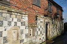
 All Saints Church, East Harnham | |
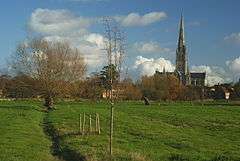 View across the water meadows from Harnham's lower part | |
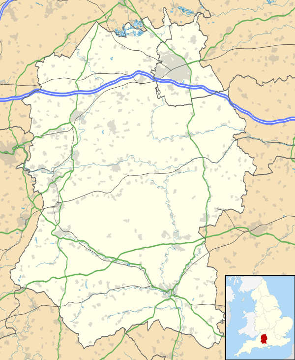 Harnham Harnham shown within Wiltshire | |
| Population | 4,992 (Ward, 2011)[1] |
| OS grid reference | SU 1427628 |
| Civil parish | |
| Unitary authority | |
| Ceremonial county | |
| Region | |
| Country | England |
| Sovereign state | United Kingdom |
| Post town | Salisbury |
| Postcode district | SP2 |
| Dialling code | 01722 |
| Police | Wiltshire |
| Fire | Dorset and Wiltshire |
| Ambulance | South Western |
| EU Parliament | South West England |
| UK Parliament | |
Harnham is a suburb of the city of Salisbury in Wiltshire, England, centred about 0.6 miles (1 km) south of Salisbury Cathedral and across the River Avon. Harnham is split into the areas of West Harnham and East Harnham.
History
Early history
The area has had human habitation since the Iron Age; a settlement is marked on Ordnance Survey maps underneath several modern houses in Harnwood Road/Old Blandford Road, a straight Roman Road.[n 1][2]
Dark and Middle Ages
Until the 19th century formation of urban and rural districts, the area lay within the Cawdon and Cawsworth Hundred of Wiltshire.[3] Harnham appears in the 1086 Domesday Book.
Road access to the city was improved in 1244 by the building of Ayleswade bridge, leading traffic from the south through Harnham instead of the older route to the west through Wilton.[4]
Post Industrial Revolution
In 1848, Samuel Lewis (publisher) described the settlement in a topographical dictionary based partly on 1841 census statistics:
- East Harnham, a tything, in the parish of Britford, union of Alderbury, hundred of Cawden and Cadworth, Salisbury and Amesbury, and south divisions of Wilts., 1½ mile (S. E. by S.) from the city of Salisbury; containing 411 inhabitants.
- West Harnham (St George) a parish, in the union of Alderbury, hundred of Cawden and Cadworth, Salisbury and Amesbury, and S. divisions of Wilts, 1½ mile (S. W. by W.) from Salisbury; containing 256 inhabitants. The living is annexed to the vicarage of Coombe-Bisset; the tithes were partly commuted for land and money payments under an Inclosure Act in 1783; and the remainder have been commuted for a rentcharge of £50.[5]
Geography
Harnham is a suburb in the southwest of Salisbury and is linked to the city by road via the Ayleswade Bridge in East Harnham, originally built across the Avon in 1244, and by foot via the Town Path across the "historic and important landscape"[6] of the Harnham Water Meadows in West Harnham.
The meadows lie between two branches of the River Nadder and extend into the outskirts of the city. They are part of an extensive irrigation system of floated water meadows, dating from the mid-seventeenth century. Now a Site of Special Scientific Interest (see East Harnham Meadows) they are still used for grazing and were voted the Best View in Britain by Country Life magazine in 2002. The meadows were made famous in John Constable's painting "Salisbury Cathedral – A View from the Water Meadow". The meadows are managed by the Harnham Water Meadows Trust and owned by the Trust jointly with the Dean and Chapter of Salisbury Cathedral.[7]
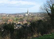
In the 13th century, Salisbury sited its new Cathedral on the flat fertile plain encircled by the Avon and protected by Harnham Hill, a chalk escarpment which rises steeply to the south. Harnham Slope comprises an area of woodland on the northern slope of Harnham Hill, including the West Harnham Chalk Pit, a 2.8 hectares (6.9 acres) geological Site of Special Scientific Interest. The upper slope is now managed as a public amenity space which, from its highest point, offers views across Harnham to the city, including the Cathedral's spire.
In 2012, Harnham was the suburb of the city with the largest area of housing valued at more than £400,000.[8]
East Harnham
East Harnham is centred on a busy roundabout and is 0.8 miles south-south west of Salisbury city centre.[9] The roundabout is one end of the A3094 to Quidhampton and is also the intersection of the A338 and the A354. Attractions in the area include Salisbury Lawn Tennis Club, Bishop Wordsworth's school playing fields and the River Avon which separates it from the rest of Salisbury. The suburb is near the Britford park and ride site, where regular Salisbury Reds bus services connect the area to the city centre.
West Harnham
West Harnham is an outer suburb of Salisbury, bisected by the A3054/Netherhampton Road, and is north west of Old Blandford Road.[10] The suburb is home to the Harnham trading estate as well as the local water meadows. West Harnham was incorporated into the city after East Harnham, being further from the city centre.
Governance
In 1904, when the city of Salisbury was made into a civil parish, its boundary was extended to include most of East Harnham. In 1927 the city expanded further to include West Harnham.[4]
The first tier of local government is Salisbury City Council, established in 2009 upon the abolition of Salisbury District. Harnham ward, with three councillors, covers most of the area although the streets north of the Netherhampton Road are in the St Martin's & Cathedral ward.[11]
Salisbury is in the area of Wiltshire Council unitary authority, which is responsible for many local government functions.
Religion
The Church of England parish of Harnham has two churches. St George's in West Harnham, dating from Norman times[12] has a canonical sundial on its south wall. The Church of All Saints in East Harnham was built in 1854.[13]
A Methodist church was built in West Harnham in the 1950s to cope with the growing demand among the local population, serving all of the south of Salisbury.
Landmarks
St George's parish church
It is certain that the church was built or re-built by 1115, the date when King Henry I signed a charter granting certain churches to Salisbury Cathedral, including the church at Harnham. The chancel was lengthened in the "E.E. style" (i.e. during the 13th century), and probably in the early 14th century the Trinity Chapel on the south side was built.[12]
St George's had some remodelling c1300, and 1300-30 is the indicated date of the south chapel; its tower mostly early 19th century, probably on the site of an earlier tower. William Butterfield led its dramatic restoration (1873–4).[12] He was responsible in the 1850s for the great church of All Saints, Margaret Street, London which broke new ground in its use of brick and of extensive polychromy detailing. The church was designated as Grade II* listed in 1952.[12]
Mill House and Old Mill
Dating from the 12th century, this Grade I listed building[14] in the lower part of West Harnham has details around its doors and windows from 1250. The building was converted in the 16th century from ecclesiastical use to Wiltshire's first paper mill, when the River Nadder was diverted to flow under it.
In the early twentieth century, the property was converted into a country club by Mary Fox-Pitt, daughter-in-law of Augustus Pitt Rivers. The atmosphere was praised by the food writer Florence White, author of Good Things in England (1932). She quotes the artist Augustus John saying "It is the best cookery in England."[15]
The building is now a hotel and the mill race can still be seen from its restaurant.
Rose and Crown Terrace
Rose and Crown Terrace is the largest of the listed buildings in East Harnham; nos 53-61 are listed and all but one have thatched roofs; the style is formal early 19th century Regency.[16]
Education
- Harnham Infant School (4-7)
- Harnham Junior School (7-11)
Culture and community
Recreational amenities include path-laid riverside walks, a thriving lawn tennis club and pitches for both local cricket and football clubs.
There is accommodation at a number of local hotels and bed & breakfasts making the area popular with both UK and overseas visitors. As well as the Old Mill, local pubs include The Rose and Crown (hotel) and The Grey Fisher.
Harnham Social Club is adjacent to the football pitch below Harnham Slope and there are community halls close to both parish churches.
Notes and references
Notes
- ↑ A road which just one mile further south forms a Scheduled Ancient Monument, Roman Road by Knighton
References
- ↑ "KS101EW Usual resident population, Salisbury Harnham E05008388, 2011". Nomis. Office for National Statistics. Retrieved 18 February 2018.
- ↑ Scheduled Ancient Monument: Iron Age Settlement Historic England. "Details from listed building database (1003728)". National Heritage List for England. Retrieved 7 November 2012.
- ↑ Map of Hundreds of Wiltshire
- 1 2 "Victoria County History - Wiltshire - Vol 3 pp69-72 - New Salisbury: Introduction". British History Online. University of London. Retrieved 9 November 2015.
- ↑ Samuel Lewis (editor) (1848). "Harlow - Harraton". A Topographical Dictionary of England. Institute of Historical Research. Retrieved 7 November 2012.
- ↑ DEFRA News Release 319/03
- ↑ Harnham Water Meadows Trust newsletters & website
- ↑ Mouseprice.com heatmap Archived 27 October 2012 at the Wayback Machine.
- ↑ https://distancecalculator.globefeed.com/UK_Distance_Result.asp?fromplace=Salisbury%2C%20UK&toplace=East%20Harnham%2C%20Salisbury%2C%20UK&dt1=ChIJt5sANlWMc0gRBqpe8oDgow0&dt2=ChIJFy9YapHrc0gRPS6uLt4Mv9g
- ↑ https://www.google.co.uk/maps/place/West+Harnham,+Salisbury+SP2+8JA/@51.0598195,-1.815825,13z/data=!4m2!3m1!1s0x4873eb9363e37551:0xf968c05e7915762d
- ↑ "About Your Council". Salisbury City Council. Retrieved 18 February 2018.
- 1 2 3 4 Historic England. "Church of St George (1242798)". National Heritage List for England. Retrieved 7 November 2012.
- ↑ Historic England. "Church of All Saints (1242276)". National Heritage List for England. Retrieved 7 November 2012.
- ↑ Historic England. "Mill House & The Old Mill (1272956)". National Heritage List for England. Retrieved 7 November 2012.
- ↑ Hollows, edited by David Bell, Joanne (2006). Historicizing lifestyle : mediating taste, consumption and identity from the 1900s to 1970s ([Online-Ausg.]. ed.). Aldershot: Ashgate. p. 50. ISBN 9780754644415.
- ↑ Historic England. "Rose and Crown Terrace (1023678)". National Heritage List for England. Retrieved 7 November 2012.