Épieds, Eure
| Épieds | |
|---|---|
| Commune | |
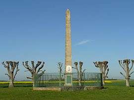 The Battle of Ivry monument | |
 Épieds Location within Normandy region  Épieds | |
| Coordinates: 48°56′09″N 1°24′00″E / 48.9358°N 1.4°ECoordinates: 48°56′09″N 1°24′00″E / 48.9358°N 1.4°E | |
| Country | France |
| Region | Normandy |
| Department | Eure |
| Arrondissement | Évreux |
| Canton | Saint-André-de-l'Eure |
| Intercommunality | CA Évreux Portes de Normandie |
| Government | |
| • Mayor (2008–2014) | Ketty Revel |
| Area1 | 4.87 km2 (1.88 sq mi) |
| Population (2008)2 | 357 |
| • Density | 73/km2 (190/sq mi) |
| Time zone | UTC+1 (CET) |
| • Summer (DST) | UTC+2 (CEST) |
| INSEE/Postal code | 27220 /27730 |
| Elevation |
91–140 m (299–459 ft) (avg. 140 m or 460 ft) |
|
1 French Land Register data, which excludes lakes, ponds, glaciers > 1 km2 (0.386 sq mi or 247 acres) and river estuaries. 2 Population without double counting: residents of multiple communes (e.g., students and military personnel) only counted once. | |
Épieds is a commune in the Eure department in the Normandy region in northern France.
Population
| Historical population | ||
|---|---|---|
| Year | Pop. | ±% |
| 1962 | 233 | — |
| 1968 | 237 | +1.7% |
| 1975 | 248 | +4.6% |
| 1982 | 228 | −8.1% |
| 1990 | 230 | +0.9% |
| 1999 | 320 | +39.1% |
| 2008 | 357 | +11.6% |
See also
References
| Wikimedia Commons has media related to Épieds (Eure). |
| Authority control |
|---|
This article is issued from
Wikipedia.
The text is licensed under Creative Commons - Attribution - Sharealike.
Additional terms may apply for the media files.