Bouafles
| Bouafles | |
|---|---|
| Commune | |
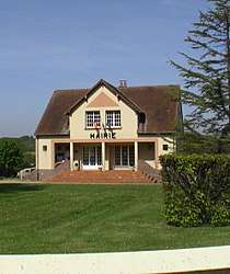 The town hall in Bouafles | |
 Bouafles Location within Normandy region  Bouafles | |
| Coordinates: 49°12′41″N 1°23′06″E / 49.2114°N 1.385°ECoordinates: 49°12′41″N 1°23′06″E / 49.2114°N 1.385°E | |
| Country | France |
| Region | Normandy |
| Department | Eure |
| Arrondissement | Les Andelys |
| Canton | Les Andelys |
| Intercommunality | Les Andelys et ses Environs |
| Government | |
| • Mayor (2008–2014) | Georges de Meyer |
| Area1 | 12.61 km2 (4.87 sq mi) |
| Population (2008)2 | 634 |
| • Density | 50/km2 (130/sq mi) |
| Time zone | UTC+1 (CET) |
| • Summer (DST) | UTC+2 (CEST) |
| INSEE/Postal code | 27097 /27700 |
| Elevation | 7–146 m (23–479 ft) |
|
1 French Land Register data, which excludes lakes, ponds, glaciers > 1 km2 (0.386 sq mi or 247 acres) and river estuaries. 2 Population without double counting: residents of multiple communes (e.g., students and military personnel) only counted once. | |
Bouafles is a commune in the Eure department in Normandy in northern France.
It located is 6 km south-west of Les Andelys on the river Seine.
Notable buildings include the Chateau De Bouafles in Rue De Mousseaux; Église Saint-Pierre in Rue Du Préleran; and the Mairie de Bouafles in Rue Haute.
In the grounds of the Chateau de Bouafles is a static caravan site, Caravaning residentiel du Chateau de Bouafles.
Population
| Historical population | ||
|---|---|---|
| Year | Pop. | ±% |
| 1962 | 168 | — |
| 1968 | 256 | +52.4% |
| 1975 | 367 | +43.4% |
| 1982 | 469 | +27.8% |
| 1990 | 682 | +45.4% |
| 1999 | 622 | −8.8% |
| 2008 | 634 | +1.9% |
See also
References
| Wikimedia Commons has media related to Bouafles. |
This article is issued from
Wikipedia.
The text is licensed under Creative Commons - Attribution - Sharealike.
Additional terms may apply for the media files.