Écouis
| Écouis | ||
|---|---|---|
| Commune | ||
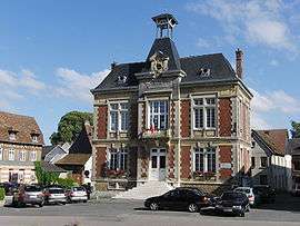 Town hall | ||
| ||
 Écouis Location within Normandy region  Écouis | ||
| Coordinates: 49°18′41″N 1°25′55″E / 49.3114°N 1.4319°ECoordinates: 49°18′41″N 1°25′55″E / 49.3114°N 1.4319°E | ||
| Country | France | |
| Region | Normandy | |
| Department | Eure | |
| Arrondissement | Les Andelys | |
| Canton | Les Andelys | |
| Intercommunality | Les Andelys et ses Environs | |
| Government | ||
| • Mayor (2008–2014) | Claude Roussel | |
| Area1 | 13.07 km2 (5.05 sq mi) | |
| Population (2008)2 | 760 | |
| • Density | 58/km2 (150/sq mi) | |
| Time zone | UTC+1 (CET) | |
| • Summer (DST) | UTC+2 (CEST) | |
| INSEE/Postal code | 27214 /27440 | |
| Elevation |
76–156 m (249–512 ft) (avg. 147 m or 482 ft) | |
|
1 French Land Register data, which excludes lakes, ponds, glaciers > 1 km2 (0.386 sq mi or 247 acres) and river estuaries. 2 Population without double counting: residents of multiple communes (e.g., students and military personnel) only counted once. | ||
.svg.png)
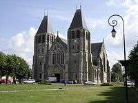
Collegiate church of Écouis
Écouis is a commune in the Eure department in northern France.
Population
| Historical population | ||
|---|---|---|
| Year | Pop. | ±% |
| 1962 | 768 | — |
| 1968 | 781 | +1.7% |
| 1975 | 734 | −6.0% |
| 1982 | 700 | −4.6% |
| 1990 | 714 | +2.0% |
| 1999 | 716 | +0.3% |
| 2008 | 760 | +6.1% |
See also
References
| Wikimedia Commons has media related to Écouis. |
This article is issued from
Wikipedia.
The text is licensed under Creative Commons - Attribution - Sharealike.
Additional terms may apply for the media files.