Giverville
| Giverville | |
|---|---|
| Commune | |
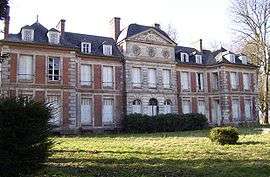 Castle of Giverville | |
 Giverville Location within Normandy region  Giverville | |
| Coordinates: 49°11′48″N 0°34′12″E / 49.1967°N 0.57°ECoordinates: 49°11′48″N 0°34′12″E / 49.1967°N 0.57°E | |
| Country | France |
| Region | Normandy |
| Department | Eure |
| Arrondissement | Bernay |
| Canton | Beuzeville |
| Government | |
| • Mayor (2008–2014) | Thierry Parrey |
| Area1 | 6.14 km2 (2.37 sq mi) |
| Population (2008)2 | 313 |
| • Density | 51/km2 (130/sq mi) |
| Time zone | UTC+1 (CET) |
| • Summer (DST) | UTC+2 (CEST) |
| INSEE/Postal code | 27286 /27560 |
| Elevation | 157–176 m (515–577 ft) |
|
1 French Land Register data, which excludes lakes, ponds, glaciers > 1 km2 (0.386 sq mi or 247 acres) and river estuaries. 2 Population without double counting: residents of multiple communes (e.g., students and military personnel) only counted once. | |
Giverville is a commune in the Eure department in northern France.
Population
| Historical population | ||
|---|---|---|
| Year | Pop. | ±% |
| 1962 | 315 | — |
| 1968 | 333 | +5.7% |
| 1975 | 358 | +7.5% |
| 1982 | 282 | −21.2% |
| 1990 | 262 | −7.1% |
| 1999 | 270 | +3.1% |
| 2006 | 294 | +8.9% |
| 2009 | 316 | +7.5% |
Sights
- The château de Giverville is a castle built in the 18th century. It was the ancestral seat of the noble Norman family "de Giverville".
See also
References
External links
| Wikimedia Commons has media related to Giverville. |
- Giverville on lion1906 (pdf)
This article is issued from
Wikipedia.
The text is licensed under Creative Commons - Attribution - Sharealike.
Additional terms may apply for the media files.