Colletot
| Colletot | |
|---|---|
| Commune | |
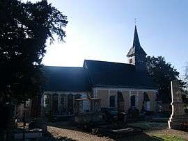 The church in Colletot | |
 Colletot Location within Normandy region  Colletot | |
| Coordinates: 49°21′03″N 0°37′11″E / 49.3508°N 0.6197°ECoordinates: 49°21′03″N 0°37′11″E / 49.3508°N 0.6197°E | |
| Country | France |
| Region | Normandy |
| Department | Eure |
| Arrondissement | Bernay |
| Canton | Pont-Audemer |
| Intercommunality | Pont-Audemer |
| Government | |
| • Mayor (2008–2014) | Odile Gilbert |
| Area1 | 4.32 km2 (1.67 sq mi) |
| Population (2008)2 | 152 |
| • Density | 35/km2 (91/sq mi) |
| Time zone | UTC+1 (CET) |
| • Summer (DST) | UTC+2 (CEST) |
| INSEE/Postal code | 27163 /27500 |
| Elevation |
60–134 m (197–440 ft) (avg. 96 m or 315 ft) |
|
1 French Land Register data, which excludes lakes, ponds, glaciers > 1 km2 (0.386 sq mi or 247 acres) and river estuaries. 2 Population without double counting: residents of multiple communes (e.g., students and military personnel) only counted once. | |
Colletot is a commune in the Eure department in northern France.
Population
| Historical population | ||
|---|---|---|
| Year | Pop. | ±% |
| 1962 | 75 | — |
| 1968 | 88 | +17.3% |
| 1975 | 88 | +0.0% |
| 1982 | 94 | +6.8% |
| 1990 | 104 | +10.6% |
| 1999 | 110 | +5.8% |
| 2008 | 152 | +38.2% |
See also
References
| Wikimedia Commons has media related to Colletot. |
| Authority control |
|---|
This article is issued from
Wikipedia.
The text is licensed under Creative Commons - Attribution - Sharealike.
Additional terms may apply for the media files.