Les Andelys
| Les Andelys | ||
|---|---|---|
| Subprefecture and commune | ||
 The church and surroundings in Les Andelys | ||
| ||
 Les Andelys Location within Normandy region  Les Andelys | ||
| Coordinates: 49°14′46″N 1°24′45″E / 49.2461°N 1.4125°ECoordinates: 49°14′46″N 1°24′45″E / 49.2461°N 1.4125°E | ||
| Country | France | |
| Region | Normandy | |
| Department | Eure | |
| Arrondissement | Les Andelys | |
| Canton | Les Andelys | |
| Intercommunality | Andelys Environs | |
| Government | ||
| • Mayor (2008–2014) | Laure Dael | |
| Area1 | 40.62 km2 (15.68 sq mi) | |
| Population (2008)2 | 8,253 | |
| • Density | 200/km2 (530/sq mi) | |
| Time zone | UTC+1 (CET) | |
| • Summer (DST) | UTC+2 (CEST) | |
| INSEE/Postal code | 27016 /27700 | |
| Elevation |
7–161 m (23–528 ft) (avg. 23 m or 75 ft) | |
|
1 French Land Register data, which excludes lakes, ponds, glaciers > 1 km2 (0.386 sq mi or 247 acres) and river estuaries. 2 Population without double counting: residents of multiple communes (e.g., students and military personnel) only counted once. | ||
.svg.png)
Les Andelys (French pronunciation: [lez‿ɑ̃dli]; Norman: Les Aundelys) is a commune in the Eure department in Normandy in northern France.
Geography
It lies on the Seine, about 35 km (22 mi) northeast of Évreux.
The commune is divided into two parts, Grand-Andely and Petit-Andely.

Panorama from the belvedere of Château Gaillard
Population
| Historical population | ||
|---|---|---|
| Year | Pop. | ±% |
| 1793 | 5,140 | — |
| 1800 | 5,160 | +0.4% |
| 1806 | 5,048 | −2.2% |
| 1821 | 5,016 | −0.6% |
| 1831 | 5,168 | +3.0% |
| 1836 | 5,085 | −1.6% |
| 1841 | 5,345 | +5.1% |
| 1846 | 5,000 | −6.5% |
| 1851 | 5,161 | +3.2% |
| 1856 | 5,026 | −2.6% |
| 1861 | 5,137 | +2.2% |
| 1866 | 5,161 | +0.5% |
| 1872 | 5,379 | +4.2% |
| 1876 | 5,574 | +3.6% |
| 1881 | 5,474 | −1.8% |
| 1886 | 5,423 | −0.9% |
| 1891 | 6,040 | +11.4% |
| 1896 | 5,923 | −1.9% |
| 1901 | 5,715 | −3.5% |
| 1906 | 5,514 | −3.5% |
| 1911 | 5,530 | +0.3% |
| 1921 | 5,237 | −5.3% |
| 1926 | 5,396 | +3.0% |
| 1931 | 5,366 | −0.6% |
| 1936 | 5,529 | +3.0% |
| 1946 | 5,238 | −5.3% |
| 1954 | 5,648 | +7.8% |
| 1962 | 6,090 | +7.8% |
| 1968 | 7,053 | +15.8% |
| 1975 | 8,196 | +16.2% |
| 1982 | 8,124 | −0.9% |
| 1990 | 8,455 | +4.1% |
| 1999 | 9,044 | +7.0% |
| 2008 | 8,253 | −8.7% |
Sights
- Château Gaillard, a medieval castle, is located in Les Andelys.
- Sainte Clotilde Miraculous Spring
- The Seine Banks
- The half-timbered houses of Petit Andely
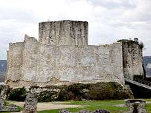
Château Gaillard, Donjon

Our Lady's Church
Personalities
Les Andelys was the birthplace of:
- Adrianus Turnebus (1512–1565), classical scholar
- Nicolas Poussin (1594–1665), painter
- Jean-Pierre Blanchard (1753–1809), balloonist, first man to cross the English Channel by air
- Charles Joshua Chaplin (1825–1891), painter
- Sir John Woodroffe (1865–1936), lawyer and writer on Indian philosophy and Tantra, lived here from 1920 until his death
- Henry Torrès (1891–1966), trial lawyer, politician, and writer
See also
References
External links
| Wikimedia Commons has media related to Les Andelys. |

- Promenade of the Andelys country (in French)
- Les Andelys City Guide
- Les Andelys News (in French)
- Les Andelys holds the second largest (in France) town flea market, the 'La Grande Foire à Tout des Andelys' every September. A mix of brocante, local produce and associations; review here.
| Authority control |
|---|
This article is issued from
Wikipedia.
The text is licensed under Creative Commons - Attribution - Sharealike.
Additional terms may apply for the media files.