List of counties in New Hampshire
There are ten counties in the U.S. state of New Hampshire. Five of the counties were created in 1769, when New Hampshire was still an English colony and not a state, during the first subdivision of the state into counties. The last counties created were Belknap County and Carroll County, in 1840.
| Counties of New Hampshire | |
|---|---|
| Location | State of New Hampshire |
| Number | 10 |
| Populations | 31,212 (Coös) – 406,678 (Hillsborough) |
| Areas | 369 square miles (960 km2) (Strafford) – 1,801 square miles (4,660 km2) (Coös) |
| Government | County government |
| Subdivisions | cities, towns, townships, villages, unincorporated territories, census designated place |

The majority of New Hampshire's counties were named for prominent British or American people or geographic locations and features. Only one county's name originates in a Native American language: Coös County, named for an Algonquian word meaning "small pines".
The counties tend to be smaller in land area towards the southern end of the state, where New Hampshire population is concentrated, and larger in land area in the less populous north.[1][2]
The FIPS county code is the five-digit Federal Information Processing Standard (FIPS) code which uniquely identifies counties and county equivalents in the United States. The three-digit number is unique to each individual county within a state, but to be unique within the entire United States, it must be prefixed by the state code. This means that, for example, while Belknap County, New Hampshire is 001, Addison County, Vermont and Alachua County, Florida are also 001. To uniquely identify Belknap County, New Hampshire, one must use the state code of 33 plus the county code of 001; therefore, the unique nationwide identifier for Belknap County, New Hampshire is 33001. The links in the column FIPS County Code are to the Census Bureau Info page for that county.[3]
List
| County | FIPS code [3] |
County seat [4] |
Est. [4] |
Formed from [5] |
Etymology [2] |
Population [6] |
Area [4][6] |
Map |
|---|---|---|---|---|---|---|---|---|
| Belknap County | 001 | Laconia | 1840 | Parts of Merrimack County and Strafford County. | Jeremy Belknap (1744–1798), early New Hampshire historian. | 60,641 | 401 sq mi (1,039 km2) |  |
| Carroll County | 003 | Ossipee | 1840 | Part of Strafford County. | Charles Carroll of Carrollton (1737–1832), the last surviving signatory of the United States Declaration of Independence. | 47,285 | 934 sq mi (2,419 km2) |  |
| Cheshire County | 005 | Keene | 1769 | One of five original counties. | English county of Cheshire. | 75,909 | 708 sq mi (1,834 km2) | 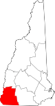 |
| Coos County | 007 | Lancaster | 1803 | Part of Grafton County. | An Algonquian word meaning "small pines". | 31,212 | 1,801 sq mi (4,665 km2) | 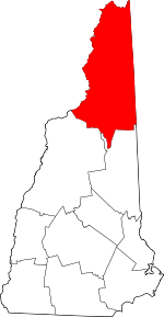 |
| Grafton County | 009 | North Haverhill | 1769 | One of five original counties. | Augustus Henry Fitzroy, 3rd Duke of Grafton (1735–1811), a Prime Minister of Great Britain (1768–1770). | 89,320 | 1,714 sq mi (4,439 km2) |  |
| Hillsborough County | 011 | Manchester and Nashua | 1769 | One of five original counties. | Wills Hill, 1st Marquess of Downshire (1718–1793), known in America as the Earl of Hillsborough, who served as the first Secretary of State for the Colonies. | 406,678 | 876 sq mi (2,269 km2) | 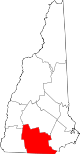 |
| Merrimack County | 013 | Concord | 1823 | Parts of Hillsborough County and Rockingham County. | The Merrimack River. | 147,994 | 934 sq mi (2,419 km2) | 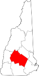 |
| Rockingham County | 015 | Brentwood | 1769 | One of five original counties. | Charles Watson-Wentworth, 2nd Marquess of Rockingham (1730–1782), a two-time Prime Minister of Great Britain (1765–1766, 1782). | 301,777 | 695 sq mi (1,800 km2) | 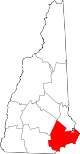 |
| Strafford County | 017 | Dover | 1769 | One of five original counties. | William Wentworth, 2nd Earl of Strafford (1626–1695), an English noble who owned colonial lands. | 126,825 | 369 sq mi (956 km2) |  |
| Sullivan County | 019 | Newport | 1827 | Part of Cheshire County. | John Sullivan (1740–1795), the third and fifth governor of New Hampshire (1786–1788, 1789–1790). | 42,967 | 537 sq mi (1,391 km2) |  |
References
- Stackpole, Everett Schermerhorn (1916). History of New Hampshire. The American Historical Society.
- "New Hampshire Counties". New Hampshire Almanac. Retrieved 2007-07-24.
- "EPA County FIPS Code Listing". US Environmental Protection Agency. Retrieved 2007-07-24.
- "NACo - Find a county". National Association of Counties. Archived from the original on 2007-07-11. Retrieved 2007-07-24.
- "New Hampshire Counties". The NHGenWeb Project. Archived from the original on 2007-07-13. Retrieved 2007-07-24.
- "New Hampshire QuickFacts from the US Census Bureau". State & County QuickFacts. Retrieved 2016-04-24.
Concord (capital) | ||
| Topics |
|  Seal of New Hampshire |
| Regions |
| |
| Counties |
| |
| Cities |
| |
| Towns |
| |
| Townships |
| |