List of counties in Nevada
There are sixteen counties and one independent city in the U.S. state of Nevada. On November 25, 1861, the first Nevada Territorial Legislature established nine counties.[1] Nevada was admitted to the Union on October 31, 1864 with eleven counties.[1] In 1969, Ormsby County and Carson City were consolidated into a single municipal government known as Carson City.[1]
| Independent city and Counties of Nevada | |
|---|---|
 Churchill
Clark
Doug
Elko
Esmeralda
Eureka
Humboldt
Lander
Lincoln
Lyon
Mineral
Nye
Pershing
Sto
Wash
White Pine
| |
| Location | Nevada, United States |
| Number | 16 Counties 1 Independent city |
| Populations | (Counties only):783 (Esmeralda) – 2,000,759 (Clark) |
| Areas | (Counties only):264 square miles (680 km2) (Storey) – 18,147 square miles (47,000 km2) (Nye) |
| Government | County government |
| Subdivisions | City, Community |
The FIPS county code is the five-digit Federal Information Processing Standard (FIPS) code which uniquely identifies counties and county equivalents in the United States.[2] The three-digit number is unique to each individual county within a state, but to be unique within the entire United States, it must be prefixed by the state code. This means that, for example, while Churchill County, Nevada is 001, Alameda County, California and Baker County, Oregon are also 001. To uniquely identify Churchill County, Nevada, one must use the state code of 32 plus the county code of 001; therefore, the unique nationwide identifier for Churchill County, Nevada is 32001. The links in the column FIPS County Code are to the Census Bureau Info page for that county.
Counties
| County |
FIPS code[2] | County seat[3] | Est.[3] | Origin[4] | Etymology[1][4] | Population[5] | Area[3][6] | Map |
|---|---|---|---|---|---|---|---|---|
| Carson City | 510 | (Independent city) | 1969 | Founded 1858, consolidated with Ormsby county in 1969. | Carson River, named in turn for Christopher Houston (Kit) Carson (1809–1868), the frontier scout and soldier. | 55,274 | 144 mi² (373 km²) | 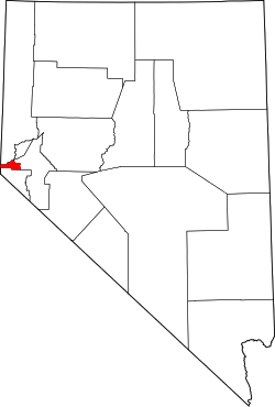 |
| Churchill County | 001 | Fallon | 1861 | Original | Sylvester Churchill (1783–1862), a general in the Mexican–American War. | 24,877 | 4,929 sq mi (12,766 km2) | 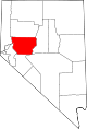 |
| Clark County | 003 | Las Vegas | 1909 | Lincoln County | William A. Clark (1839–1925), former United States Senator from Montana, and builder of a railroad line through the area. | 2,204,079 | 7,911 sq mi (20,489 km2) | 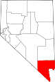 |
| Douglas County | 005 | Minden | 1861 | Original | Stephen Arnold Douglas (1813–1861), former United States Senator from Illinois. | 46,997 | 710 sq mi (1,839 km2) |  |
| Elko County | 007 | Elko | 1869 | Lander County | A Shoshoni word meaning white woman. It is said, among the very old Shoshoni, that this is where they first saw a white woman. | 48,818 | 17,182 sq mi (44,501 km2) |  |
| Esmeralda County | 009 | Goldfield | 1861 | Original | Esmeralda Mining District, named in turn for the legend that a massive amount of emeralds was buried in what is now Nevada. Esmeralda is the Spanish and Portuguese word for emerald. | 783 | 3,589 sq mi (9,295 km2) |  |
| Eureka County | 011 | Eureka | 1873 | Lander County | Greek expression Eureka, meaning I have found it!, in reference to deposits of silver found in the vicinity. | 1,987 | 4,176 sq mi (10,816 km2) |  |
| Humboldt County | 013 | Winnemucca | 1861 | Original | Humboldt River, named in turn for Alexander von Humboldt (1769–1859), a German naturalist and explorer. | 16,528 | 9,658 sq mi (25,014 km2) |  |
| Lander County | 015 | Battle Mountain | 1862 | Churchill County & Humboldt County | Frederick W. Lander (1821–1862), an American Civil War general and developer of the area. | 5,775 | 5,494 sq mi (14,229 km2) |  |
| Lincoln County | 017 | Pioche | 1866 | Nye County and territory ceded by Arizona. | Abraham Lincoln (1809–1865), the sixteenth President of the United States. | 5,345 | 10,635 sq mi (27,545 km2) |  |
| Lyon County | 019 | Yerington | 1861 | Original | General Nathaniel Lyon (1818–1861), who was killed in action at the Battle of Wilson's Creek. | 51,980 | 1,994 sq mi (5,164 km2) |  |
| Mineral County | 021 | Hawthorne | 1911 | Esmeralda County | Mineral deposits in the area. | 4,772 | 3,757 sq mi (9,731 km2) | 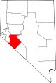 |
| Nye County | 023 | Tonopah | 1864 | Esmeralda County | James W. Nye (1815–1876), a governor of the Nevada Territory and U.S. senator from Nevada. | 43,946 | 18,147 sq mi (47,001 km2) | 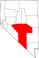 |
| Pershing County | 027 | Lovelock | 1919 | Humboldt County | John Joseph (Black Jack) Pershing (1860–1948), the World War I general. | 6,753 | 6,009 sq mi (15,563 km2) | 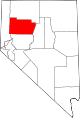 |
| Storey County | 029 | Virginia City | 1861 | Original | Edward Farris Storey (1829–1860), a captain killed at Pyramid Lake in the 1860 Paiute War. | 4,010 | 264 sq mi (684 km2) |  |
| Washoe County | 031 | Reno | 1861 | Original | The Washo, a small Indian tribe that inhabits the area. | 460,587 | 6,342 sq mi (16,426 km2) |  |
| White Pine County | 033 | Ely | 1869 | Lander County | Heavy growth of pine trees in the area, thought to be white pine. | 10,030 | 8,877 sq mi (22,991 km2) |  |
Defunct counties
- Bullfrog County, Nevada, formed in 1987 from part of Nye county. Creation declared unconstitutional and abolished in 1989.[1]
- Lake County, Nevada, one of the original nine counties formed in 1861. Renamed Roop County in 1862. Part became Lassen County, California in 1864. Nevada remainder annexed in 1883 to Washoe county.[1]
- Ormsby County, Nevada, one of the original nine counties formed in 1861. Consolidated in 1969 with the county seat, Carson City, forming the independent city of that name.[1]
References
- "Political History of Nevada". Nevada State Library and Archives. Archived from the original on 2007-09-27. Retrieved 2007-08-17.
- "EPA County FIPS Code Listing". US Environmental Protection Agency. Archived from the original on 2012-10-08. Retrieved 2007-08-18.
- "NACo – Find a county". National Association of Counties. Archived from the original on July 6, 2007. Retrieved 2007-08-16.
- "Counties of Nevada". Nevada-History.org. Retrieved 2007-08-18.
- "American Fact Finder [2010 Census]". United States Census Bureau. Archived from the original on 2020-02-13. Retrieved 2018-05-07.
- "Nevada QuickFacts". U.S. Census Bureau. Retrieved 2007-08-16. (2000 Census)
Carson City (capital) | ||
| Topics |
|  |
| Society |
| |
| Regions |
| |
| Metro areas |
| |
| Counties |
| |
| Cities and communities |
| |
| Former counties |
| |