List of counties in Vermont
There are fourteen counties in the U.S. state of Vermont. These counties together contain 255 political units, or places, including 237 towns, 9 cities, 5 unincorporated areas, and 4 gores. Each county has a county seat, often referred to as a "shire town." In 1779, Vermont had two counties. The western side of the state was called Bennington County and the eastern was called Cumberland County.[1] In 1781, Cumberland County was separated into three counties in Vermont plus another county named Washington (not the same as the modern Washington County) that eventually became part of New Hampshire. Today's Washington County was known as Jefferson County from its creation in 1810 until it was renamed in 1814. Essex County, Orleans County, and Caledonia County are commonly referred to as the Northeast Kingdom.
| Counties of Vermont | |
|---|---|
 Franklin
GI
Orleans
Lamoille
Caledonia
Essex
Washington
Chittenden
Addison
Orange
Rutland
Windsor
Bennington
Windham
| |
| Location | State of Vermont |
| Number | 14 |
| Populations | 6,163 (Essex) – 161,382 (Chittenden) |
| Areas | 83 square miles (210 km2) (Grand Isle) – 971 square miles (2,510 km2) (Windsor) |
| Government | County government |
| Subdivisions | Cities, towns, villages, unincorporated communities |
The FIPS county code is the five-digit Federal Information Processing Standard (FIPS) code which uniquely identifies counties and county equivalents in the United States. The three-digit number is unique to each individual county within a state, but to be unique within the entire United States, it must be prefixed by the state code. This means that, for example, while Addison County, Vermont is 001, Belknap County, New Hampshire and Alachua County, Florida are also 001. To uniquely identify Addison County, Vermont, one must use the state code of 50 plus the county code of 001; therefore, the unique nationwide identifier for Addison County, Vermont is 50001. The links in the column FIPS County Code are to the Census Bureau Info page for that county.[2]
List
| County |
FIPS code[2] | Shire town[3] | Est.[3] | Origin[4] | Etymology[4] | Population[3][5] | Area[3][5] | Map |
|---|---|---|---|---|---|---|---|---|
| Addison County | 001 | Middlebury | 1785 | Part of Rutland County. | Joseph Addison (1672–1719), an English politician and writer. | 37,035 | 770 sq mi (1,995 km²) |  |
| Bennington County | 003 | Bennington, Manchester | 1779 | One of the original two counties. | Benning Wentworth (1696–1770), the colonial governor of New Hampshire (1741–1766). | 36,317 | 676 sq mi (1,751 km2) |  |
| Caledonia County | 005 | St. Johnsbury | 1792 | Part of Orange County. | Latin name for Scotland. | 30,780 | 651 sq mi (1,686 km2) |  |
| Chittenden County | 007 | Burlington | 1787 | Part of Addison County. | Thomas Chittenden (1730–1797), first governor of Vermont (1791–1797). | 161,382 | 539 sq mi (1,396 km2) | 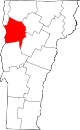 |
| Essex County | 009 | Guildhall | 1792 | Part of Orange County. | Essex, a county in England. | 6,163 | 665 sq mi (1,722 km2) | 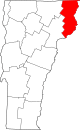 |
| Franklin County | 011 | St. Albans (city) | 1792 | Part of Chittenden County. | Benjamin Franklin (1706–1790), one of the most critical Founding Fathers of the United States. | 48,799 | 637 sq mi (1,650 km2) |  |
| Grand Isle County | 013 | North Hero | 1802 | Part of Chittenden County and Franklin County. | Largest island in Lake Champlain. | 6,861 | 83 sq mi (215 km2) | 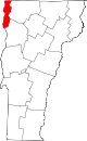 |
| Lamoille County | 015 | Hyde Park (town) | 1835 | Parts of Chittenden County, Franklin County, Orleans County and Washington County. | La Mouelle (meaning the seagull), named by French explorer Samuel de Champlain (~1570–1635). | 25,235 | 461 sq mi (1,194 km2) |  |
| Orange County | 017 | Chelsea | 1781 | Part of Cumberland County. | Prince William (1650–1702) of Orange. | 28,899 | 689 sq mi (1,785 km2) | 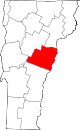 |
| Orleans County | 019 | Newport (city) | 1792 | Part of Chittenden County and Orange County. | City of Orléans, France. | 27,100 | 697 sq mi (1,805 km2) |  |
| Rutland County | 021 | Rutland (city) | 1781 | Part of Bennington County. | Town of Rutland, Massachusetts. | 59,736 | 932 sq mi (2,414 km2) |  |
| Washington County | 023 | Montpelier | 1810 | Parts of Orange County, Caledonia County, and Chittenden County. | George Washington (1732–1799), first President of the United States (1789–1797). | 58,612 | 690 sq mi (1,787 km2) | 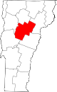 |
| Windham County | 025 | Newfane | 1779[a] (as Cumberland County) (renamed 1781) | One of the original two counties. | Town of Windham, Connecticut. | 43,386 | 789 sq mi (2,044 km2) | 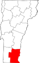 |
| Windsor County | 027 | Woodstock | 1781 | Part of Cumberland County. | Town of Windsor, Connecticut. | 55,737 | 971 sq mi (2,515 km2) |  |
See also
- List of cities in Vermont
- List of gores in Vermont
- List of towns in Vermont
- List of former United States counties
Notes
References
- "Vermont County Information". Genealogy Trails. Retrieved 2007-07-22.
- "EPA County FIPS Code Listing". EPA. Archived from the original on 2009-08-17. Retrieved 2007-07-22.
- "NACo - Find a county". National Association of Counties. Retrieved February 24, 2012.
- Kane, Joseph & Aiken, Charles (2004). The American Counties: Origins of County Names, Dates of Creation, and Population Data, 1950-2000. Scarecrow Press. p. 1. ISBN 0-8108-5036-2. Retrieved September 11, 2016.
Origins of County Names.
- "Vermont QuickFacts". U.S. Census Bureau. Retrieved September 11, 2016. (2010 Census)
- "Vermont: Consolidated Chronology of State and County Boundaries". The Newberry Library. 2008. Archived from the original on 2012-02-24. Retrieved 2009-06-03.
Montpelier (capital) | ||
| Regions |
|  Seal of Vermont |
| Counties |
| |
| Cities |
| |
| Towns (pop. >5000) |
| |
| Festivals |
| |
| Topics |
| |
| Society |
| |