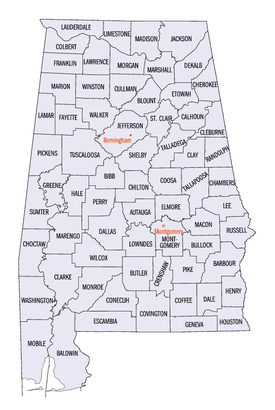
List of counties in Alabama
The U.S. state of Alabama has 67 counties.[1] Each county serves as the local level of government within its borders. The land enclosed by the present state borders was joined to the United States of America gradually. Following the American Revolutionary War, West Florida was ceded to Spain by treaty while the remainder was organized primarily as the Mississippi Territory, and later the Alabama Territory.[2] The territorial assembly established some of the earliest county divisions that have survived to the present, including the earliest county formation, that of Washington County, created on June 4, 1800.[3] In 1814, the Treaty of Fort Jackson opened the territory to American settlers, which in turn led to a more rapid rate of county creation. Alabama was admitted to the Union as the 22nd state in 1819.[4] The Alabama state legislature formed additional counties from former native lands as the Indian Removal Act took effect and settlers populated different areas of Alabama.[5] In 1820, Alabama had 29 counties. By 1830 there were 36 and Native Americans still occupied large areas of land in northeast and far western Alabama. By 1840, 49 counties had been created; 52 by 1850; 65 by 1870; and the present 67 counties by 1903.[6] Houston County was the last county created in the state, on February 9, 1903.[3]
| Counties of Alabama | |
|---|---|
 Alabama counties (clickable map) | |
| Location | State of Alabama |
| Number | 67 |
| Populations | Greatest: 658,466 (Jefferson) Least: 9,045 (Greene) Average: 72,587 (2016) |
| Areas | Largest: 1,590 sq mi (4,100 km2) (Baldwin) Smallest: 535 sq mi (1,390 km2) (Etowah) Average: 782 sq mi (2,030 km2) |
| Government | County government |
| Subdivisions | cities, towns, unincorporated communities, census designated place |
According to 2010 U. S. Census data, the average population of Alabama's 67 counties is 71,399, with Jefferson County as the most populous (658,466), and Greene County (9,045) the least.[7] The average land area is 756 sq mi (1,958 km2). The largest county is Baldwin (1,590 sq mi, 4,118 km2) and the smallest is Etowah (535 sq mi, 1,386 km2).[8] The Constitution of Alabama requires that any new county in Alabama cover at least 600 square miles (1,600 km2) in area, effectively limiting the creation of new counties in the state.[9]
The Alabama Department of Revenue's Motor Vehicle Division issues standard automobile license plates that bear a one- or two-digit number identifying the county in which the vehicle is registered. This number is given in the fourth column in the table below. The first three prefixes are reserved for the state's historically most populous counties, and thereafter proceed alphabetically. Individual license plate numbers are assigned sequentially in each licensing office. The numbers are in the format XAA1111 or XXAA111, depending on whether the prefix is one or two digits. Overflow registrations are accommodated by substituting a letter for one of the registration numbers, such that XXZ999Z is followed by XXA0A0A.[10]
The Federal Information Processing Standard (FIPS) code, used by the United States government to uniquely identify counties, is provided with each entry. The FIPS code links in the table point to U. S. Census "quick facts" pages for each county. Alabama's FIPS state code is 01.
Counties
| County |
FIPS code[11] | County seat[3] | License # [12] |
Est.[3] | Formed from[13] | Etymology[6][14] | Density [15] |
Population (2010)[15] | Land Area[15] | Map |
|---|---|---|---|---|---|---|---|---|---|---|
| Autauga County | 001 | Prattville | 4 | 1818 | Montgomery County | The Autauga or Atagi people, Native Americans who were a sub-group of the Alibamu | 94.4 | 54,571 | 594.44 sq mi (1,540 km2) |  |
| Baldwin County | 003 | Bay Minette | 5 | 1809 | Washington County and West Florida | Abraham Baldwin (1754–1807), U.S. legislator from Georgia | 114.6 | 182,265 | 1,589.78 sq mi (4,118 km2) |  |
| Barbour County | 005 | Clayton | 6 | 1832 | Pike County | James Barbour (1775–1842), Governor of Virginia and U.S. Senator | 31.0 | 27,457 | 884.88 sq mi (2,292 km2) |  |
| Bibb County | 007 | Centreville | 7 | 1818 | Montgomery County (as Cahawba County) | William Wyatt Bibb (1781–1820), 1st Governor of Alabama | 36.8 | 22,915 | 622.58 sq mi (1,612 km2) |  |
| Blount County | 009 | Oneonta | 8 | 1818 | Montgomery County and Creek territories | Willie Blount (1768–1835), Governor of Tennessee | 88.9 | 57,322 | 644.78 sq mi (1,670 km2) |  |
| Bullock County | 011 | Union Springs | 9 | 1866 | Barbour, Macon, Montgomery, and Pike counties | Edward Bullock (1822–1861), colonel in the Confederate States Army | 17.5 | 10,914 | 622.80 sq mi (1,613 km2) | 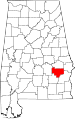 |
| Butler County | 013 | Greenville | 10 | 1819 | Conecuh and Monroe counties | William Butler (?–1818), captain in Creek War | 27.0 | 20,947 | 776.83 sq mi (2,012 km2) |  |
| Calhoun County | 015 | Anniston | 11 | 1832 | St. Clair County (as Benton County) | John C. Calhoun (1782–1850), 7th U.S. Vice President | 195.7 | 118,572 | 605.87 sq mi (1,569 km2) |  |
| Chambers County | 017 | LaFayette | 12 | 1832 | Montgomery County | Henry H. Chambers (1790–1826), U.S. Senator | 57.4 | 34,215 | 596.53 sq mi (1,545 km2) |  |
| Cherokee County | 019 | Centre | 13 | 1836 | Cherokee territory | Cherokee people, whose lands included Northeast Alabama | 46.9 | 25,989 | 553.70 sq mi (1,434 km2) |  |
| Chilton County | 021 | Clanton | 14 | 1868 | Autauga, Bibb, Perry, and Shelby counties (as Baker County) | William Parish Chilton (1810–1871), Alabama Supreme Court Justice and Confederate congressman | 63.0 | 43,643 | 692.85 sq mi (1,794 km2) | 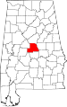 |
| Choctaw County | 023 | Butler | 15 | 1847 | Sumter and Washington counties | Choctaw people, whose lands included Alabama | 15.2 | 13,859 | 913.50 sq mi (2,366 km2) |  |
| Clarke County | 025 | Grove Hill | 16 | 1812 | Washington County | John Clarke (1766–1832), general from Georgia | 20.9 | 25,833 | 1,238.46 sq mi (3,208 km2) |  |
| Clay County | 027 | Ashland | 17 | 1866 | Randolph and Talladega counties | Henry Clay (1777–1852), U.S. legislator from Kentucky | 23.1 | 13,932 | 603.96 sq mi (1,564 km2) |  |
| Cleburne County | 029 | Heflin | 18 | 1866 | Calhoun, Randolph, and Talladega counties | Patrick Cleburne (1828–1864), Major General in Confederate States Army | 26.7 | 14,972 | 560.10 sq mi (1,451 km2) |  |
| Coffee County | 031 | Elba and Enterprise[16] | 19 | 1841 | Dale County | John Coffee (1772–1833), military leader in War of 1812 and Creek War | 73.6 | 49,948 | 678.97 sq mi (1,759 km2) |  |
| Colbert County | 033 | Tuscumbia | 20 | 1867 | Franklin County | George Colbert (1764–1839) and Levi Colbert (1759–1834), Chickasaw chiefs | 91.8 | 54,428 | 592.62 sq mi (1,535 km2) |  |
| Conecuh County | 035 | Evergreen | 21 | 1818 | Monroe County | The Conecuh River, which flows through the county | 15.6 | 13,228 | 850.16 sq mi (2,202 km2) |  |
| Coosa County | 037 | Rockford | 22 | 1832 | Montgomery County | The Coosa River, which flows through the county, and is itself named after a Native American village | 17.7 | 11,539 | 650.93 sq mi (1,686 km2) | 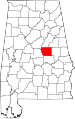 |
| Covington County | 039 | Andalusia | 23 | 1821 | Henry County | Leonard Covington (1768–1813), Brigadier General in War of 1812 and U.S. Congressman | 36.6 | 37,765 | 1,030.46 sq mi (2,669 km2) |  |
| Crenshaw County | 041 | Luverne | 24 | 1866 | Butler, Coffee, Covington, Lowndes, and Pike Counties | Anderson Crenshaw (1783–1847), Alabama Supreme Court justice and early settler | 22.8 | 13,906 | 608.84 sq mi (1,577 km2) |  |
| Cullman County | 043 | Cullman | 25 | 1877 | Blount, Morgan, and Winston counties | Colonel John G. Cullmann (1823–1895), founder of county seat | 109.4 | 80,406 | 734.84 sq mi (1,903 km2) |  |
| Dale County | 045 | Ozark | 26 | 1824 | Covington and Henry counties | Samuel Dale (1772–1841), Brigadier General and state legislator | 89.6 | 50,251 | 561.15 sq mi (1,453 km2) |  |
| Dallas County | 047 | Selma | 27 | 1818 | Monroe and Montgomery counties | Alexander James Dallas (1759–1817), U.S. Secretary of Treasury | 44.8 | 43,820 | 978.69 sq mi (2,535 km2) |  |
| DeKalb County | 049 | Fort Payne | 28 | 1836 | Cherokee territory | Johann de Kalb (1721–1780), major general in American Revolutionary War | 91.52 | 71,109 | 777.09 sq mi (2,013 km2) |  |
| Elmore County | 051 | Wetumpka | 29 | 1866 | Autauga, Coosa, Montgomery, and Tallapoosa counties | John Archer Elmore (1762–1834), Revolutionary War veteran | 128.32 | 79,303 | 618.48 sq mi (1,602 km2) |  |
| Escambia County | 053 | Brewton | 30 | 1868 | Baldwin and Conecuh counties | Escambia Creek, a tributary of the Conecuh River | 40.55 | 38,319 | 945.08 sq mi (2,448 km2) | 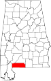 |
| Etowah County | 055 | Gadsden | 31 | 1866 | Blount, Calhoun, Cherokee, DeKalb, Marshall, and St. Clair counties (as Baine County) | Etowah Indian Mounds | 195.20 | 104,430 | 534.99 sq mi (1,386 km2) | 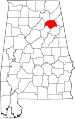 |
| Fayette County | 057 | Fayette | 32 | 1824 | Marion, Pickens, Tuscaloosa, and Walker counties | Gilbert du Motier, marquis de La Fayette (1757–1834), Revolutionary War commander | 27.45 | 17,241 | 627.66 sq mi (1,626 km2) | 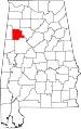 |
| Franklin County | 059 | Russellville | 33 | 1818 | Cherokee territory | Benjamin Franklin (1706–1790), politician, diplomat, inventor, and publisher | 50.01 | 31,704 | 633.82 sq mi (1,642 km2) |  |
| Geneva County | 061 | Geneva | 34 | 1868 | Coffee, Dale, and Henry counties | Named after Geneva, New York, the origin of several early settlers | 46.67 | 26,790 | 574.41 sq mi (1,488 km2) |  |
| Greene County | 063 | Eutaw | 35 | 1819 | Marengo and Tuscaloosa counties | Nathanael Greene (1742–1786), Revolutionary War general | 13.98 | 9,045 | 647.11 sq mi (1,676 km2) |  |
| Hale County | 065 | Greensboro | 36 | 1867 | Greene, Marengo, Perry, and Tuscaloosa counties | Stephen F. Hale (1816–1862), lieutenant colonel in Confederate States Army | 24.47 | 15,760 | 643.94 sq mi (1,668 km2) |  |
| Henry County | 067 | Abbeville | 37 | 1819 | Conecuh County | Patrick Henry (1736–1799), Revolutionary War patriot and Governor of Virginia | 30.79 | 17,302 | 561.75 sq mi (1,455 km2) |  |
| Houston County | 069 | Dothan | 38 | 1903 | Dale, Geneva, and Henry counties | George S. Houston (1811–1879), 24th Governor of Alabama and U.S. Congressman | 175.08 | 101,547 | 579.82 sq mi (1,502 km2) |  |
| Jackson County | 071 | Scottsboro | 39 | 1819 | Cherokee territory | Andrew Jackson (1767–1845), 7th U.S. President | 49.38 | 53,227 | 1,077.87 sq mi (2,792 km2) | 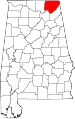 |
| Jefferson County | 073 | Birmingham | 1 | 1819 | Blount County | Thomas Jefferson (1743–1826), 3rd U.S. President | 592.68 | 658,466 | 1,111.28 sq mi (2,878 km2) | 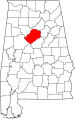 |
| Lamar County | 075 | Vernon | 40 | 1867 | Fayette and Marion counties (as Jones County) | Lucius Q. C. Lamar (1825–1893), U.S. Supreme Court justice | 24.07 | 14,564 | 604.85 sq mi (1,567 km2) |  |
| Lauderdale County | 077 | Florence | 41 | 1818 | Cherokee and Chickasaw territories | James Lauderdale (1780–1814), Colonel in War of 1812 | 138.79 | 92,709 | 667.70 sq mi (1,729 km2) | 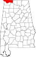 |
| Lawrence County | 079 | Moulton | 42 | 1818 | Cherokee territory | James Lawrence (1781–1813), naval officer in War of 1812 | 49.69 | 34,339 | 690.68 sq mi (1,789 km2) |  |
| Lee County | 081 | Opelika | 43 | 1866 | Chambers, Macon, Russell, and Tallapoosa counties | Robert E. Lee (1807–1870), Commander of the Confederate States Army | 230.67 | 140,247 | 607.54 sq mi (1,574 km2) |  |
| Limestone County | 083 | Athens | 44 | 1818 | Elk and Madison counties | Limestone Creek, named for local geological deposits | 147.83 | 82,782 | 559.94 sq mi (1,450 km2) |  |
| Lowndes County | 085 | Hayneville | 45 | 1830 | Butler, Dallas, and Montgomery counties | William Lowndes (1782–1822), U.S. Congressman from South Carolina | 15.78 | 11,299 | 715.91 sq mi (1,854 km2) | 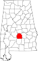 |
| Macon County | 087 | Tuskegee | 46 | 1832 | Montgomery County | Nathaniel Macon (1758–1837), U.S. legislator from North Carolina | 35.22 | 21,452 | 608.89 sq mi (1,577 km2) |  |
| Madison County | 089 | Huntsville | 47 | 1808 | Cherokee and Chickasaw territories | James Madison (1751–1836), 4th U.S. President | 417.47 | 334,811 | 801.59 sq mi (2,076 km2) | 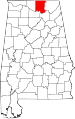 |
| Marengo County | 091 | Linden | 48 | 1818 | Choctaw territory | Battle of Marengo | 21.52 | 21,027 | 976.88 sq mi (2,530 km2) | 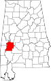 |
| Marion County | 093 | Hamilton | 49 | 1818 | Tuscaloosa County | Francis Marion (1732–1795), military leader in American Revolutionary War | 41.48 | 30,776 | 742.29 sq mi (1,923 km2) |  |
| Marshall County | 095 | Guntersville | 50 | 1836 | Blount and Jackson counties and Cherokee territory | John Marshall (1755–1835), Chief Justice of the United States 1801–1835 | 164.34 | 93,019 | 565.84 sq mi (1,466 km2) |  |
| Mobile County | 097 | Mobile | 2 | 1812 | Mobile District of West Florida after annexation into Mississippi Territory | Mobile Bay, on which county is located, and which is itself named after the Maubila tribe of Native Americans | 336.04 | 412,992 | 1,229.44 sq mi (3,184 km2) | 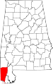 |
| Monroe County | 099 | Monroeville | 51 | 1815 | Creek territory | James Monroe (1758–1831), 5th U.S. President | 22.48 | 23,068 | 1,025.67 sq mi (2,656 km2) |  |
| Montgomery County | 101 | Montgomery | 3 | 1816 | Monroe County | Lemuel P. Montgomery (1786–1814), Major in Creek War | 292.55 | 229,363 | 784.25 sq mi (2,031 km2) | 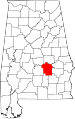 |
| Morgan County | 103 | Decatur | 52 | 1818 | Cherokee territory (as Cotaco County) | Daniel Morgan (1736–1802), U.S. Congressman | 206.37 | 119,490 | 579.34 sq mi (1,500 km2) |  |
| Perry County | 105 | Marion | 53 | 1819 | Cahawba, Dallas, Marengo, and Tuscaloosa counties | Oliver Hazard Perry (1795–1819), naval officer in War of 1812 | 14.71 | 10,591 | 719.66 sq mi (1,864 km2) |  |
| Pickens County | 107 | Carrollton | 54 | 1820 | Tuscaloosa County | Andrew Pickens (1739–1817), General in the Revolutionary War | 22.41 | 19,746 | 881.41 sq mi (2,283 km2) | 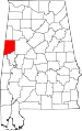 |
| Pike County | 109 | Troy | 55 | 1821 | Henry and Montgomery counties | Zebulon Pike (1779–1813), explorer and officer in War of 1812 | 48.96 | 32,899 | 672.09 sq mi (1,741 km2) | 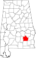 |
| Randolph County | 111 | Wedowee | 56 | 1832 | St. Clair and Shelby counties | John Randolph (1773–1833), U.S. Senator from Virginia | 39.44 | 22,913 | 580.55 sq mi (1,504 km2) |  |
| Russell County | 113 | Phenix City | 57 | 1832 | Barbour, Bullock, Lee and Macon counties | Gilbert C. Russell (1782–1861), officer in Creek War | 82.60 | 52,947 | 641.14 sq mi (1,661 km2) | 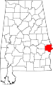 |
| St. Clair County | 115 | Ashville and Pell City | 59 | 1818 | Shelby County | Arthur St. Clair (1736–1818), President of Continental Congress | 132.27 | 83,593 | 631.90 sq mi (1,637 km2) |  |
| Shelby County | 117 | Columbiana | 58 | 1818 | Montgomery County | Isaac Shelby (1750–1826), Governor of Kentucky | 248.52 | 195,085 | 784.93 sq mi (2,033 km2) |  |
| Sumter County | 119 | Livingston | 60 | 1832 | Choctaw territory | Thomas Sumter (1734–1832), U.S. Congressman from South Carolina | 15.22 | 13,763 | 903.89 sq mi (2,341 km2) |  |
| Talladega County | 121 | Talladega | 61 | 1832 | St. Clair and Shelby counties | Talatigi, Creek Indian name for the county seat, meaning "border town" | 111.66 | 82,291 | 736.78 sq mi (1,908 km2) |  |
| Tallapoosa County | 123 | Dadeville | 62 | 1832 | Montgomery and Shelby counties | Tallapoosa River | 58.04 | 41,616 | 716.52 sq mi (1,856 km2) | 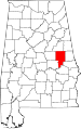 |
| Tuscaloosa County | 125 | Tuscaloosa | 63 | 1818 | Montgomery County and Choctaw territory | Iroquoian name for the Black Warrior River | 147.24 | 194,656 | 1,321.75 sq mi (3,423 km2) | 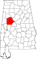 |
| Walker County | 127 | Jasper | 64 | 1823 | Blount, Jefferson, and Tuscaloosa counties | John Williams Walker (1783–1823), U.S. Senator from Alabama | 84.73 | 67,023 | 791.19 sq mi (2,049 km2) | 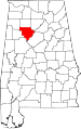 |
| Washington County | 129 | Chatom | 65 | 1800 | Adams and Pickering counties of Mississippi Territory | George Washington (1732–1799), 1st U.S. President | 16.28 | 17,581 | 1,080.21 sq mi (2,798 km2) |  |
| Wilcox County | 131 | Camden | 66 | 1819 | Dallas and Monroe counties | Joseph M. Wilcox (1790–1814), lieutenant in Creek War | 13.14 | 11,670 | 888.50 sq mi (2,301 km2) |  |
| Winston County | 133 | Double Springs | 67 | 1850 | Walker County (as Hancock County) | John A. Winston (1812–1871), 15th Governor of Alabama | 40.10 | 24,484 | 612.98 sq mi (1,588 km2) |  |
Former county names
| County[6] | Named for[6] | Changed to[3] |
|---|---|---|
| Baine County | David W. Baine, Colonel in the Civil War | Etowah County in 1868 |
| Baker County | Alfred Baker, a local landowner | Chilton County in 1874 |
| Benton County | Thomas Hart Benton, U. S. Senator from Missouri | Calhoun County in 1858, honoring Benton's rival John C. Calhoun of South Carolina after Benton's renunciation of slavery |
| Cahawba County | former state capital of Cahawba | Bibb County in 1820 |
| Cotaco County | Cotaco Creek, a tributary of the Tennessee River | Morgan County in 1821 |
| Hancock County | John Hancock, signer of the Declaration of Independence | Winston County in 1858 |
| Jones County | Josiah Jones, a local political leader | Covington County (its former name) in 1868 after Jones refused the honor |
| Jones County | E.P. Jones, a local landowner | Sanford County, which subsequently became Lamar County in 1877 |
| Sanford County | H.C. Sanford, a local landowner | Lamar County in 1877 |
Former counties
| County | Established | Dissolved | Named for | Notes |
|---|---|---|---|---|
| Decatur County | December 7, 1821 | December 28, 1825 | Commodore Stephen Decatur of the United States Navy. | Created in 1822 with Woodville as its county seat. Abolished several years later, divided between Madison County and Jackson County. |
| Elk County[17] | May 9, 1817 | January 26, 1818 | Elk River | Established by Mississippi Territory prior to Mississippi–Alabama split; abolished prior to Alabama statehood |
See also
- List of census county divisions in Alabama
References
- Specific
- "Find A County". National Association of Counties. Archived from the original on September 2, 2012. Retrieved April 7, 2012.
- "Alabama History Timeline, 1701–1800". Alabama Department of Archives and History. Retrieved May 18, 2009.
- National Association of Counties. "NACo – Find a county". Archived from the original on March 9, 2008. Retrieved April 30, 2008.
- "Alabama History Timeline, 1801–1860". Alabama Department of Archives and History. Retrieved May 18, 2009.
- "Alabama Counties: Cherokee". Alabama Department of Archives and History. Retrieved December 29, 2008.
- Foscue, Virginia O. (1989) Place Names in Alabama. Tuscaloosa, Alabama: University of Alabama Press. ISBN 0-8173-0410-X
- "U.S. Census website". U.S. Census Bureau. Retrieved March 13, 2011.
- "2010 Census U.S. Gazetteer Files". U.S. Census Bureau. Retrieved March 13, 2011.
- Wikisource:Alabama State Constitution of 1901/Initial Constitution#Section 39
- Nicholson, David. "Alabama License Plates, 1969–present". License Plates of North America, 1969–present. Retrieved August 8, 2007.
- "EPA County FIPS Code Listing". EPA.gov. Archived from the original on October 8, 2012. Retrieved February 23, 2008.
- Nicholson, David. "Alabama County Codes". License Plates of North America, 1969–present. Retrieved May 25, 2009.
- Owen, Thomas McAdory; Owen, Marie Bankhead (1921). History of Alabama and Dictionary of Alabama Biography. Chicago: S.J. Clarke Publishing Company.
- "Alabama Counties". Alabama Department of Archives and History. Retrieved June 1, 2009.
- "Community Facts". U.S. Census Bureau. Retrieved August 9, 2017.
- Coffee County, Alabama. "History of Coffee County". Archived from the original on October 27, 2011. Retrieved August 19, 2011.
- McDonald, William Lindsey (2003) [1997]. A Walk Through the Past: People and Places of Florence and Lauderdale County, Alabama. Killen, Alabama: Bluewater Publications. pp. 223–224. ISBN 9780971994560. Retrieved May 8, 2012.
- General
- "CountyState.info Alabama". Official County Websites. Retrieved September 13, 2007.
External links
- Map series showing evolution of county boundaries. Cartographic Research Laboratory. University of Alabama Department of Geography.
- Alabama Counties Alabama Counties Features. Digital Alabama
Montgomery (capital) | ||
| Topics |
|  Seal of Alabama |
| Society |
| |
| Regions |
| |
| Flora and fauna |
| |
| Largest cities |
| |
| Metros |
| |
| Counties |
| |