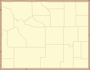
List of counties in Wyoming
This is a list of counties in Wyoming. There are 23 counties in the U.S. state of Wyoming. There were originally five counties in the Wyoming Territory: Laramie and Carter, established in 1867; Carbon and Albany established in 1868; and Uinta, an annexed portion of Utah and Idaho, extending from Montana (including Yellowstone Park) to the Wyoming-Utah boundary.[1] On July 10, 1890, Wyoming was admitted to the Union with thirteen counties in it. Ten more counties were created after statehood.[1]
| Counties of Wyoming | |
|---|---|
 Albany
Big Horn
Campb
Carbon
Converse
Crook
Fremont
Gos
Hot Spr
Johnson
Laramie
Lincoln
Natrona
Niobr
Park
Plat
Sheridan
Sublette
Sweetwater
Teton
Uinta
Washakie
Weston
| |
| Location | State of Wyoming |
| Number | 23 |
| Populations | 2,456 (Niobrara) – 94,483 (Laramie) |
| Areas | 2,004 square miles (5,190 km2) (Hot Springs) – 10,426 square miles (27,000 km2) (Sweetwater) |
| Government | County government |
| Subdivisions | cities, towns, townships, unincorporated communities, indian reservations, census designated place |
Three counties were renamed after their creation. Carter County was renamed Sweetwater County on December 1, 1869.[2] Hanover County existed for seven days in 1911 before it was renamed Washakie County.[3] Pease County, formed in 1875, was renamed Johnson County in 1879.[3]
The Federal Information Processing Standard (FIPS) code, which is used by the United States government to uniquely identify states and counties, is provided with each entry.[4] Wyoming's code is 56, which when combined with any county code would be written as 56XXX. The FIPS code for each county links to census data for that county.[5]
List
| County |
FIPS code [5] |
County seat [6] |
Est. [1] |
Formed from [1] |
Etymology [7] |
Population [6][8] |
Area [6][9] |
Map |
|---|---|---|---|---|---|---|---|---|
| Albany County | 001 | Laramie | 1868 | One of the original five counties. | City of Albany, New York, from which early settlers hailed. | 37,276 | 4,274 sq mi (11,070 km2) |  |
| Big Horn County | 003 | Basin | 1896 | Parts of Sheridan County, Johnson County, and Fremont County. | Big Horn Mountains, a mountain range extending into northern Wyoming | 11,794 | 3,137 sq mi (8,125 km2) |  |
| Campbell County | 005 | Gillette | 1911 | Parts of Weston County and Crook County. | John Allen Campbell (1835–80), first governor of the Wyoming Territory (1869–75) | 47,874 | 4,797 sq mi (12,424 km2) |  |
| Carbon County | 007 | Rawlins | 1868 | One of the original five counties. | The vast coal beds in the county. | 15,666 | 7,897 sq mi (20,453 km2) | 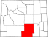 |
| Converse County | 009 | Douglas | 1888 | Parts of Albany County and Laramie County. | A.R. Converse, a banker and rancher from Cheyenne, Wyoming. | 14,008 | 4,255 sq mi (11,020 km2) |  |
| Crook County | 011 | Sundance | 1875 | Parts of Laramie County and Albany County. | General George Crook (1828–90), who served in the American Civil War and the Indian Wars. | 7,155 | 2,859 sq mi (7,405 km2) |  |
| Fremont County | 013 | Lander | 1884 | Part of Sweetwater County. | John C. Frémont (1813–90), explorer, U.S. Senator for California, and the first presidential candidate of a major party to run on a platform in opposition to slavery | 41,110 | 9,183 sq mi (23,784 km2) |  |
| Goshen County | 015 | Torrington | 1911 | Part of Laramie County. | The Land of Goshen, a Biblical paradise. | 13,636 | 2,225 sq mi (5,763 km2) |  |
| Hot Springs County | 017 | Thermopolis | 1911 | Parts of Fremont County, Big Horn County, and Park County. | The hot springs at Thermopolis within the county borders. | 4,822 | 2,004 sq mi (5,190 km2) |  |
| Johnson County | 019 | Buffalo | 1875 | Parts of Carbon County and Sweetwater County. | E.P. Johnson, a lawyer from Cheyenne, Wyoming. | 8,615 | 4,166 sq mi (10,790 km2) | 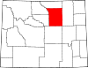 |
| Laramie County | 021 | Cheyenne | 1867 | One of the original five counties. | Jacques La Ramee (1785?–1821), a French-Canadian fur trapper. | 94,483 | 2,686 sq mi (6,957 km2) |  |
| Lincoln County | 023 | Kemmerer | 1911 | Part of Uinta County. | Abraham Lincoln (1809–65), U.S. President (1861–65) | 17,961 | 4,069 sq mi (10,539 km2) | 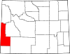 |
| Natrona County | 025 | Casper | 1888 | Part of Carbon County. | The natron, or soda deposits found within the county's borders. Natrona means natron in Spanish. | 78,621 | 5,340 sq mi (13,831 km2) | 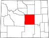 |
| Niobrara County | 027 | Lusk | 1911 | Part of Converse County. | The Niobrara River, which flows through the state. Niobrara is Omaha for flat or broad river. | 2,456 | 2,626 sq mi (6,801 km2) | 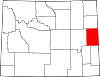 |
| Park County | 029 | Cody | 1909 | Part of Big Horn County. | Yellowstone National Park | 28,702 | 6,943 sq mi (17,982 km2) | 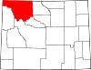 |
| Platte County | 031 | Wheatland | 1911 | Part of Laramie County. | North Platte River. Plate is French for flat. | 8,756 | 2,085 sq mi (5,400 km2) |  |
| Sheridan County | 033 | Sheridan | 1888 | Part of Johnson County. | Philip Sheridan (1831–88), American Civil War general. | 29,596 | 2,523 sq mi (6,535 km2) |  |
| Sublette County | 035 | Pinedale | 1921 | Parts of Fremont County and Lincoln County. | William Sublette, pioneer and fur trapper. | 10,368 | 4,882 sq mi (12,644 km2) |  |
| Sweetwater County | 037 | Green River | 1867 | One of the original five counties. | Sweetwater River (a tributary of the North Platte River), which flows through the state. | 45,267 | 10,426 sq mi (27,003 km2) | 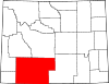 |
| Teton County | 039 | Jackson | 1921 | Part of Lincoln County. | Teton Range, a small mountain range of the Rocky Mountains Wyoming-Idaho state line | 21,675 | 4,008 sq mi (10,381 km2) | 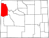 |
| Uinta County | 041 | Evanston | 1869 | One of the original five counties. | The Uinta Mountains, named in turn after the Uintah Native American people. | 21,025 | 2,082 sq mi (5,392 km2) |  |
| Washakie County | 043 | Worland | 1911 | Part of Big Horn County | Washakie (1804–1900), a leader of Shoshone Native American tribe. | 8,464 | 2,240 sq mi (5,802 km2) |  |
| Weston County | 045 | Newcastle | 1890 | Part of Crook County | John Weston (1831–95), who was responsible for bringing the first railroad to the area. | 7,082 | 2,398 sq mi (6,211 km2) |  |
References
- "General Facts About Wyoming". State of Wyoming. Archived from the original on 2007-05-12. Retrieved 2007-07-20.
- "CARTER COUNTY RECORDS". Wyoming State Archives. Archived from the original on 2008-05-03. Retrieved 2007-07-20.
- "Wyoming Counties". American Local History Network. RootsWeb.com. Retrieved 2007-07-20.
- "FIPS Publish 6-4". National Institute of Standards and Technology. Archived from the original on 2013-09-29. Retrieved 2007-07-20.
- "EPA County FIPS Code Listing". US Environmental Protection Agency. Archived from the original on 2013-07-30. Retrieved 2007-07-20.
- "NACo - Find a county". National Association of Counties. Archived from the original on 2007-09-30. Retrieved 2007-07-20.
- "Name Derivations of Wyoming Counties". Wyoming State Library. Archived from the original on 2013-08-25. Retrieved 2007-07-20.
- "Annual Estimates of the Resident Population for Counties of Wyoming: April 1, 2010 to July 1, 2011". 2011 Population Estimates. United States Census Bureau, Population Division. April 2012. Archived from the original (CSV) on January 20, 2013. Retrieved April 18, 2012.
- "Wyoming QuickFacts". U.S. Census Bureau. Archived from the original on 2013-10-21. Retrieved 2007-07-20. (2000 Census)
Cheyenne (capital) | ||
| Topics |
|  Seal of Wyoming |
| Society |
| |
| Regions |
| |
| Cities | ||
| Counties |
| |