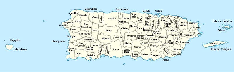
Municipalities of Puerto Rico
The municipalities of Puerto Rico number seventy-eight incorporated towns and cities. Each municipality is led by a mayor and divided into barrios, though the latter are not vested with any political authority. Every municipality is governed by the Autonomous Municipalities Act of 1991, which establishes that every municipality must have an elected strong mayor with a municipal legislature as the form of government. Each legislature must be unicameral, with the number of members related to adequate representation of the total municipality's population. In contrast to other jurisdictions, both the mayors and the municipal legislators are elected on the same date and for the same term of office.
| Municipalities of Puerto Rico | |
|---|---|
 | |
| Location | Commonwealth of Puerto Rico |
| Number | 78 |
| Populations | 1,818 (Culebra) – 395,326 (San Juan) |
| Areas | 4.84 square miles (12.5 km2) (Cataño) – 125.95 square miles (326.2 km2) (Arecibo) |
| Government | Mayor–council government |
| Subdivisions | Barrio |
From a political and urban design perspective, several differences and similarities exist among municipalities of differing sizes. For instance, municipalities with 50,000 inhabitants or more are considered incorporated cities, while those with fewer than 50,000 are considered incorporated towns.[1] Size affects the autonomy exercised by the jurisdiction: cities provide and manage their own services, while towns typically depend on nearby cities for certain services. All municipalities have a barrio called pueblo proper (English: 'town'), which typically is the site of that municipality's historic Spanish colonial settlement. With development over time, it typically has become that municipality's urban core. Municipalities with large populations, however, may have an urban core that consist of several barrios.
Other differences exist among the municipalities. Economic activity, for example, tends to be concentrated in the metropolitan areas surrounding the cities of San Juan, Ponce, Arecibo, Caguas, Mayaguez, Aguadilla, and Humacao, and most towns are commuter towns. Statistically, the municipality with the largest number of inhabitants is San Juan, with around 400,000, while Culebra is the smallest, with around 1,800. Arecibo is the largest in terms of geography, with around 125 mi2, and Cataño the smallest, with around 4.8 mi2.
Overview
Because Puerto Rico was a Spanish colony until 1898, its system of local government bears more resemblance to that of the Hispanophone nations of the Americas than to local government in the United States and some other Anglophone countries. Thus, there are no first-order administrative divisions akin to counties, as defined by the United States Government; instead, Puerto Rico has 78 municipalities or "municipios" as the secondary unit of administration. For U.S. Census purposes, the municipalities are considered county equivalents. The municipalities are grouped into eight electoral districts, but these do not possess administrative functions. In 1991, the Autonomous Municipalities Act was passed, which slightly modified the rights and responsibilities of Puerto Rican municipalities with the aim of decentralizing control and improving government services.[2]
Every municipality is composed of several barrios, except for Florida, which has only one barrio. The municipality of Ponce has the largest number of barrios, 31.[3][4][5][6][7]
Every municipality (except San Juan) also has an urban area made up of one or more barrios.[8] When the urban area is made up of only one barrio, it is called "Barrio Pueblo". Some urban areas are made up of multiple barrios: Ponce's urban area, for example, is made up of 12 barrios. All of San Juan's barrios are urban barrios, and the municipality of San Juan is composed of urban barrios only - thus, the entire municipality of San Juan consists of one large urban zone only.[9]
Every municipality's urban zone is named by the same name as the municipality. For example, the municipality of Caguas has an urban zone called Caguas - just like the municipality. Some municipalities' urban zones are termed "pueblo" (town) while others are termed "ciudad" (city). The difference resides in the population of the municipality: if the municipality has an urban zone below 50,000 inhabitants, then its urban zone is called a pueblo. If a municipality has a population above 50,000 inhabitants in its urban zone, then its urban zone is called a ciudad.[1]
Politics
The municipalities elect a Mayor and a Municipal Legislature in the general elections every four years.
Demographics
| Municipality | FIPS code[10] | Founded | Population (2010)[11] | % of Population | Area[12] |
|---|---|---|---|---|---|
| Adjuntas | 001 | 1815 | 19,483 | 0.52% | 66.69 sq mi (172.73 sq km) |
| Aguada | 003 | 1639 | 41,959 | 1.12% | 30.85 sq mi (79.90 sq km) |
| Aguadilla | 005 | 1775 | 60,949 | 1.62% | 36.53 sq mi (94.61 sq km) |
| Aguas Buenas | 007 | 1838 | 28,659 | 0.76% | 30.08 sq mi (77.92 sq km) |
| Aibonito | 009 | 1824 | 25,900 | 0.69% | 31.31 sq mi (81.10 sq km) |
| Añasco | 011 | 1733 | 29,261 | 0.78% | 39.29 sq mi (101.75 sq km) |
| Arecibo | 013 | 1616 | 96,440 | 2.57% | 125.95 sq mi (326.20 sq km) |
| Arroyo | 015 | 1855 | 19,575 | 0.52% | 15.01 sq mi (38.87 sq km) |
| Barceloneta | 017 | 1881 | 24,816 | 0.66% | 18.69 sq mi (48.41 sq km) |
| Barranquitas | 019 | 1803 | 30,318 | 0.81% | 34.25 sq mi (88.71 sq km) |
| Bayamón | 021 | 1772 | 208,116 | 5.54% | 44.32 sq mi (114.80 sq km) |
| Cabo Rojo | 023 | 1771 | 50,917 | 1.36% | 70.37 sq mi (182.27 sq km) |
| Caguas | 025 | 1775 | 142,893 | 3.81% | 58.60 sq mi (151.77 sq km) |
| Camuy | 027 | 1807 | 35,159 | 0.94% | 46.35 sq mi (120.06 sq km) |
| Canóvanas | 029 | 1909 | 47,648 | 1.27% | 32.87 sq mi (85.12 sq km) |
| Carolina | 031 | 1816 | 176,762 | 4.71% | 45.32 sq mi (117.38 sq km) |
| Cataño | 033 | 1927 | 28,140 | 0.75% | 4.84 sq mi (12.55 sq km) |
| Cayey | 035 | 1773 | 48,119 | 1.28% | 51.93 sq mi (134.51 sq km) |
| Ceiba | 037 | 1838 | 13,631 | 0.36% | 29.04 sq mi (75.20 sq km) |
| Ciales | 039 | 1820 | 18,782 | 0.50% | 66.53 sq mi (172.31 sq km) |
| Cidra | 041 | 1809 | 43,480 | 1.16% | 36.02 sq mi (93.29 sq km) |
| Coamo | 043 | 1579 | 40,512 | 1.08% | 78.10 sq mi (202.27 sq km) |
| Comerío | 045 | 1826 | 20,778 | 0.55% | 28.40 sq mi (73.56 sq km) |
| Corozal | 047 | 1795 | 37,142 | 0.99% | 42.57 sq mi (110.26 sq km) |
| Culebra | 049 | 1880 | 1,818 | 0.05% | 11.62 sq mi (30.10 sq km) |
| Dorado | 051 | 1842 | 38,165 | 1.02% | 23.09 sq mi (59.80 sq km) |
| Fajardo | 053 | 1772 | 36,993 | 0.99% | 29.86 sq mi (77.34 sq km) |
| Florida | 054 | 1971 | 12,680 | 0.34% | 15.21 sq mi (39.39 sq km) |
| Guánica | 055 | 1914 | 19,427 | 0.52% | 37.05 sq mi (95.96 sq km) |
| Guayama | 057 | 1736 | 45,362 | 1.21% | 64.99 sq mi (168.32 sq km) |
| Guayanilla | 059 | 1833 | 21,581 | 0.57% | 42.27 sq mi (109.48 sq km) |
| Guaynabo | 061 | 1769 | 97,924 | 2.61% | 27.58 sq mi (71.43 sq km) |
| Gurabo | 063 | 1815 | 45,369 | 1.21% | 27.89 sq mi (72.23 sq km) |
| Hatillo | 065 | 1823 | 41,953 | 1.12% | 41.78 sq mi (108.21 sq km) |
| Hormigueros | 067 | 1874 | 17,250 | 0.46% | 11.34 sq mi (29.37 sq km) |
| Humacao | 069 | 1722 | 58,466 | 1.56% | 44.75 sq mi (115.90 sq km) |
| Isabela | 071 | 1819 | 45,631 | 1.22% | 55.30 sq mi (143.23 sq km) |
| Jayuya | 073 | 1911 | 16,642 | 0.44% | 44.53 sq mi (115.33 sq km) |
| Juana Díaz | 075 | 1798 | 79,897 | 2.13% | 60.28 sq mi (156.12 sq km) |
| Juncos | 077 | 1797 | 40,290 | 1.07% | 26.49 sq mi (68.61 sq km) |
| Lajas | 079 | 1883 | 25,753 | 0.69% | 59.95 sq mi (159.15 sq km) |
| Lares | 081 | 1827 | 30,753 | 0.82% | 61.45 sq mi (159.15 sq km) |
| Las Marías | 083 | 1871 | 9,881 | 0.26% | 46.36 sq mi (120.07 sq km) |
| Las Piedras | 085 | 1773 | 38,675 | 1.03% | 33.88 sq mi (87.75 sq km) |
| Loíza | 087 | 1719 | 30,060 | 0.80% | 19.37 sq mi (50.17 sq km) |
| Luquillo | 089 | 1797 | 20,068 | 0.53% | 25.81 sq mi (66.85 sq km) |
| Manatí | 091 | 1738 | 44,113 | 1.17% | 46.13 sq mi (119.48 sq km) |
| Maricao | 093 | 1874 | 6,276 | 0.17% | 36.62 sq mi (94.85 sq km) |
| Maunabo | 095 | 1799 | 12,225 | 0.33% | 21.07 sq mi (54.57 sq km) |
| Mayagüez | 097 | 1760 | 89,080 | 2.37% | 77.65 sq mi (201.11 sq km) |
| Moca | 099 | 1772 | 40,109 | 1.07% | 50.34 sq mi (130.38 sq km) |
| Morovis | 101 | 1818 | 32,610 | 0.87% | 38.87 sq mi (100.67 sq km) |
| Naguabo | 103 | 1821 | 26,720 | 0.71% | 51.66 sq mi (133.80 sq km) |
| Naranjito | 105 | 1824 | 30,402 | 0.81% | 27.40 sq mi (70.97 sq km) |
| Orocovis | 107 | 1772 | 23,423 | 0.62% | 63.62 sq mi (164.78 sq km) |
| Patillas | 109 | 1811 | 19,277 | 0.51% | 46.7 sq mi (120.95 sq km) |
| Peñuelas | 111 | 1793 | 24,282 | 0.65% | 44.62 sq mi (115.57 sq km) |
| Ponce | 113 | 1692 | 166,327 | 4.43% | 114.76 sq mi (297.23 sq km) |
| Quebradillas | 115 | 1823 | 25,919 | 0.69% | 22.68 sq mi (58.74 sq km) |
| Rincón | 117 | 1771 | 15,200 | 0.40% | 14.29 sq mi (37.01 sq km) |
| Río Grande | 119 | 1840 | 54,304 | 1.45% | 60.62 sq mi (157.01 sq km) |
| Sabana Grande | 121 | 1813 | 25,265 | 0.67% | 35.83 sq mi (92.80 sq km) |
| Salinas | 123 | 1851 | 31,078 | 0.83% | 69.37 sq mi (179.67 sq km) |
| San Germán | 125 | 1573 | 35,527 | 0.95% | 54.50 sq mi (141.15 sq km) |
| San Juan | 127 | 1519[13] | 395,326 | 10.53% | 47.85 sq mi (123.93 sq km) |
| San Lorenzo | 129 | 1811 | 41,058 | 1.09% | 53.11 sq mi (137.55 sq km) |
| San Sebastián | 131 | 1752 | 42,430 | 1.13% | 70.42 sq mi (182.39 sq km) |
| Santa Isabel | 133 | 1842 | 23,274 | 0.62% | 34.02 sq mi (88.119 sq km) |
| Toa Alta | 135 | 1751 | 74,066 | 1.97% | 27.02 sq mi (69.98 sq km) |
| Toa Baja | 137 | 1745 | 89,609 | 2.39% | 23.24 sq mi (60.19 sq km) |
| Trujillo Alto | 139 | 1801 | 74,842 | 1.99% | 20.76 sq mi (53.77 sq km) |
| Utuado | 141 | 1739 | 33,149 | 0.88% | 113.53 sq mi (294.04 sq km) |
| Vega Alta | 143 | 1775 | 39,951 | 1.06% | 27.73 sq mi (71.82 sq km) |
| Vega Baja | 145 | 1776 | 59,662 | 1.59% | 45.86 sq mi (118.78 sq km) |
| Vieques | 147 | 1852 | 9,301 | 0.25% | 50.77 sq mi (131.49 sq km) |
| Villalba | 149 | 1917 | 26,073 | 0.69% | 35.64 sq mi (92.31 sq km) |
| Yabucoa | 151 | 1793 | 37,941 | 1.01% | 55.21 sq mi (142.99 sq km) |
| Yauco | 153 | 1756 | 42,043 | 1.12% | 68.19 sq mi (176.61 sq km) |
Racial composition
The following is an alphabetical list of the municipalities and their population together with a breakdown of their racial composition.
| Municipality (2010) | White (both Hispanic and Non-Hispanic)[14][15] | Black (Both Hispanic and Non-Hispanic)[16] | Amerindian (Both Hispanic and Non-Hispanic) | Asian (Both Hispanic and Non-Hispanic) | Multiracial (Both Hispanic and Non-Hispanic) | Hispanic (Of any Race) |
|---|---|---|---|---|---|---|
| Adjuntas | 93.1 | 3.1 | 0.3 | 0.0 | 3.4 | 99.6 |
| Aguada | 86.6 | 5.3 | 0.3 | 0.1 | 7.7 | 99.4 |
| Aguadilla | 83.0 | 7.4 | 0.3 | 0.2 | 8.2 | 98.5 |
| Aguas Buenas | 72.5 | 12.6 | 0.6 | 0.1 | 14.2 | 99.5 |
| Aibonito | 83.5 | 7.3 | 0.2 | 0.0 | 9.0 | 99.3 |
| Añasco | 82.0 | 7.2 | 0.4 | 0.1 | 10.3 | 99.2 |
| Arecibo | 84.5 | 6.1 | 0.4 | 0.1 | 7.9 | 99.2 |
| Arroyo | 53.5 | 32.5 | 0.9 | 0.2 | 13.0 | 99.1 |
| Barceloneta | 80.7 | 7.6 | 0.3 | 0.1 | 11.2 | 99.4 |
| Barranquitas | 86.0 | 5.4 | 0.3 | 0.0 | 8.3 | 99.3 |
| Bayamón | 78.3 | 10.3 | 0.6 | 0.2 | 10.7 | 99.0 |
| Cabo Rojo | 84.1 | 5.4 | 0.3 | 0.1 | 10.1 | 98.9 |
| Caguas | 76.1 | 11.0 | 0.6 | 0.2 | 12.1 | 99.1 |
| Camuy | 87.9 | 4.1 | 0.3 | 0.1 | 7.6 | 99.4 |
| Canóvanas | 61.2 | 21.6 | 0.9 | 0.2 | 16.1 | 99.2 |
| Carolina | 64.3 | 22.8 | 0.9 | 0.4 | 11.7 | 98.6 |
| Cataño | 70.7 | 14.4 | 1.0 | 0.3 | 13.7 | 99.0 |
| Cayey | 79.9 | 8.3 | 0.4 | 0.1 | 11.3 | 99.3 |
| Ceiba | 70.6 | 16.5 | 0.7 | 0.1 | 12.0 | 98.8 |
| Ciales | 89.5 | 4.2 | 0.1 | 0.0 | 6.2 | 99.7 |
| Cidra | 76.6 | 8.3 | 0.4 | 0.1 | 14.6 | 99.4 |
| Coamo | 76.8 | 10.4 | 0.3 | 0.1 | 12.3 | 99.6 |
| Comerío | 78.6 | 8.6 | 0.6 | 0.1 | 12.1 | 99.6 |
| Corozal | 85.4 | 5.3 | 0.2 | 0.1 | 9.0 | 99.4 |
| Culebra | 56.9 | 26.6 | 0.9 | 0.2 | 15.4 | 91.7 |
| Dorado | 69.5 | 15.7 | 0.7 | 0.2 | 13.9 | 98.0 |
| Fajardo | 64.8 | 18.6 | 0.7 | 0.3 | 15.7 | 98.2 |
| Florida | 90.4 | 4.6 | 0.3 | 0.1 | 4.5 | 99.6 |
| Guánica | 79.9 | 7.7 | 0.5 | 0.0 | 11.8 | 99.4 |
| Guayama | 68.2 | 18.5 | 0.8 | 0.1 | 12.3 | 99.1 |
| Guayanilla | 81.9 | 8.3 | 0.4 | 0.1 | 9.3 | 99.5 |
| Guaynabo | 79.4 | 9.8 | 0.4 | 0.2 | 10.1 | 98.2 |
| Gurabo | 72.5 | 14.6 | 0.4 | 0.1 | 12.5 | 99.2 |
| Hatillo | 87.3 | 4.4 | 0.2 | 0.1 | 8.0 | 99.2 |
| Hormigueros | 81.2 | 8.3 | 0.4 | 0.1 | 10.0 | 99.5 |
| Humacao | 66.1 | 18.5 | 0.8 | 0.2 | 14.3 | 99.0 |
| Isabela | 83.4 | 7.5 | 0.3 | 0.1 | 8.6 | 99.0 |
| Jayuya | 90.7 | 3.4 | 0.4 | 0.1 | 5.5 | 99.6 |
| Juana Díaz | 75.3 | 14.3 | 0.5 | 0.1 | 9.9 | 99.4 |
| Juncos | 71.7 | 13.7 | 0.5 | 0.1 | 14.1 | 99.3 |
| Lajas | 80.6 | 5.2 | 0.2 | 0.1 | 13.9 | 99.3 |
| Lares | 91.1 | 3.0 | 0.2 | 0.1 | 5.6 | 99.3 |
| Las Marías | 86.3 | 5.3 | 0.4 | 0.0 | 8.0 | 99.4 |
| Las Piedras | 70.5 | 11.8 | 0.5 | 0.1 | 17.1 | 99.4 |
| Loíza | 26.5 | 64.3 | 0.5 | 0.1 | 8.6 | 99.4 |
| Luquillo | 65.5 | 20.8 | 0.9 | 0.2 | 12.6 | 97.9 |
| Manatí | 81.8 | 8.7 | 0.5 | 0.1 | 8.9 | 99.2 |
| Maricao | 89.2 | 4.8 | 0.4 | 0.0 | 5.3 | 99.4 |
| Maunabo | 47.9 | 30.4 | 0.8 | 0.1 | 20.8 | 99.2 |
| Mayagüez | 78.7 | 8.2 | 0.8 | 0.2 | 12.1 | 98.9 |
| Moca | 89.5 | 4.5 | 0.2 | 0.1 | 5.8 | 99.4 |
| Morovis | 88.4 | 5.2 | 0.2 | 0.1 | 6.1 | 99.4 |
| Naguabo | 71.1 | 15.9 | 0.4 | 0.2 | 12.4 | 99.2 |
| Naranjito | 84.2 | 6.0 | 0.5 | 0.1 | 9.4 | 99.5 |
| Orocovis | 86.7 | 6.2 | 0.4 | 0.1 | 6.6 | 99.6 |
| Patillas | 61.7 | 19.9 | 0.6 | 0.1 | 17.7 | 99.3 |
| Peñuelas | 81.8 | 9.2 | 0.4 | 0.2 | 8.4 | 99.4 |
| Ponce | 82.0 | 9.0 | 0.5 | 0.2 | 8.3 | 99.2 |
| Quebradillas | 89.2 | 3.7 | 0.1 | 0.1 | 6.9 | 99.3 |
| Rincón | 85.7 | 5.3 | 0.5 | 0.2 | 8.2 | 96.4 |
| Río Grande | 61.9 | 24.6 | 0.7 | 0.2 | 12.6 | 99.0 |
| Sabana Grande | 85.3 | 5.5 | 0.4 | 0.0 | 8.8 | 99.5 |
| Salinas | 67.4 | 16.4 | 0.6 | 0.1 | 15.5 | 99.3 |
| San Germán | 83.4 | 5.6 | 0.4 | 0.1 | 10.5 | 99.2 |
| San Juan | 68.0 | 18.6 | 0.8 | 0.4 | 12.2 | 98.2 |
| San Lorenzo | 76.1 | 9.9 | 0.8 | 0.1 | 13.2 | 99.5 |
| San Sebastián | 88.5 | 3.0 | 0.3 | 0.1 | 8.1 | 99.3 |
| Santa Isabel | 73.0 | 15.6 | 0.5 | 0.1 | 10.9 | 99.6 |
| Toa Alta | 76.3 | 9.6 | 0.4 | 0.1 | 13.5 | 99.3 |
| Toa Baja | 70.2 | 16.8 | 0.6 | 0.3 | 12.1 | 99.0 |
| Trujillo Alto | 72.1 | 14.6 | 0.7 | 0.2 | 12.3 | 98.9 |
| Utuado | 92.7 | 2.7 | 0.2 | 0.1 | 4.3 | 99.4 |
| Vega Alta | 71.2 | 14.9 | 0.7 | 0.2 | 13.1 | 98.7 |
| Vega Baja | 77.3 | 11.5 | 0.5 | 0.1 | 10.6 | 99.3 |
| Vieques | 58.7 | 28.1 | 0.7 | 0.1 | 12.5 | 94.3 |
| Villalba | 82.1 | 8.5 | 0.2 | 0.0 | 9.1 | 99.7 |
| Yabucoa | 65.6 | 14.1 | 0.5 | 0.2 | 19.8 | 99.3 |
| Yauco | 83.0 | 5.9 | 0.3 | 0.1 | 9.6 | 99.5 |
| Puerto Rico | 75.8 | 12.4 | 0.5 | 0.2 | 11.1 | 99.0 |
Finances
In 2012, 36 of the 78 municipalities (46%) were experiencing a budget deficit.[17] In total, the combined debt carried by the municipalities stands at about US$590 million.[lower-alpha 1]
| Municipality | Mayor's party | Population[11] | Surplus or deficit[19] | Surplus or deficit per capita[19] | Public debt[19] | Public debt per capita[19] | ||||||||
|---|---|---|---|---|---|---|---|---|---|---|---|---|---|---|
| Adjuntas | PNP | 19,483 |
|
|
|
| ||||||||
| Aguada | PPD | 41,959 |
|
|
|
| ||||||||
| Aguadilla | PNP | 60,949 |
|
|
|
| ||||||||
| Aguas Buenas | PPD | 28,659 |
|
|
|
| ||||||||
| Aibonito | PNP | 25,900 |
|
|
|
| ||||||||
| Añasco | PPD | 29,261 |
|
|
|
| ||||||||
| Arecibo | PNP | 96,440 |
|
|
|
| ||||||||
| Arroyo | PPD | 19,575 |
|
|
|
| ||||||||
| Barceloneta | PPD | 24,816 |
|
|
|
| ||||||||
| Barranquitas | PNP | 30,318 |
|
|
|
| ||||||||
| Bayamón | PNP | 208,116 |
|
|
|
| ||||||||
| Cabo Rojo | PPD | 50,917 |
|
|
|
| ||||||||
| Caguas | PPD | 142,893 |
|
|
|
| ||||||||
| Camuy | PNP | 35,159 |
|
|
|
| ||||||||
| Canóvanas | PNP | 47,648 |
|
|
|
| ||||||||
| Carolina | PPD | 176,762 |
|
|
|
| ||||||||
| Cataño | PPD | 28,140 |
|
|
|
| ||||||||
| Cayey | PPD | 48,119 |
|
|
|
| ||||||||
| Ceiba | PNP | 13,631 |
|
|
|
| ||||||||
| Ciales | PPD | 18,782 |
|
|
|
| ||||||||
| Cidra | PNP | 43,480 |
|
|
|
| ||||||||
| Coamo | PPD | 40,512 |
|
|
|
| ||||||||
| Comerío | PPD | 20,778 |
|
|
|
| ||||||||
| Corozal | PPD | 37,142 |
|
|
|
| ||||||||
| Culebra | PPD | 1,818 |
|
|
|
| ||||||||
| Dorado | PPD | 38,165 |
|
|
|
| ||||||||
| Fajardo | PNP | 36,993 |
|
|
|
| ||||||||
| Florida | PNP | 12,680 |
|
|
|
| ||||||||
| Guánica | PNP | 19,427 |
|
|
|
| ||||||||
| Guayama | PPD | 45,362 |
|
|
|
| ||||||||
| Guayanilla | PPD | 21,581 |
|
|
|
| ||||||||
| Guaynabo | PNP | 97,924 |
|
|
|
| ||||||||
| Gurabo | PNP | 45,369 |
|
|
|
| ||||||||
| Hatillo | PPD | 41,953 |
|
|
|
| ||||||||
| Hormigueros | PPD | 17,250 |
|
|
|
| ||||||||
| Humacao | PPD | 58,466 |
|
|
|
| ||||||||
| Isabela | PPD | 45,631 |
|
|
|
| ||||||||
| Jayuya | PPD | 16,642 |
|
|
|
| ||||||||
| Juana Díaz | PPD | 79,897 |
|
|
|
| ||||||||
| Juncos | PPD | 40,290 |
|
|
|
| ||||||||
| Lajas | PPD | 25,753 |
|
|
|
| ||||||||
| Lares | PNP | 30,753 |
|
|
|
| ||||||||
| Las Marías | PPD | 9,881 |
|
|
|
| ||||||||
| Las Piedras | PNP | 38,675 |
|
|
|
| ||||||||
| Loíza | PNP | 30,060 |
|
|
|
| ||||||||
| Luquillo | PPD | 20,068 |
|
|
|
| ||||||||
| Manatí | PNP | 44,113 |
|
|
|
| ||||||||
| Maricao | PNP | 6,276 |
|
|
|
| ||||||||
| Maunabo | PPD | 12,225 |
|
|
|
| ||||||||
| Mayagüez | PPD | 89,080 |
|
|
|
| ||||||||
| Moca | PNP | 40,109 |
|
|
|
| ||||||||
| Morovis | PNP | 32,610 |
|
|
|
| ||||||||
| Naguabo | PNP | 26,720 |
|
|
|
| ||||||||
| Naranjito | PNP | 30,402 |
|
|
|
| ||||||||
| Orocovis | PNP | 23,423 |
|
|
|
| ||||||||
| Patillas | PPD | 19,277 |
|
|
|
| ||||||||
| Peñuelas | PPD | 24,282 |
|
|
|
| ||||||||
| Ponce | PNP | 166,327 |
|
|
|
| ||||||||
| Quebradillas | PPD | 25,919 |
|
|
|
| ||||||||
| Rincón | PPD | 15,200 |
|
|
|
| ||||||||
| Río Grande | PPD | 54,304 |
|
|
|
| ||||||||
| Sabana Grande | PPD | 25,265 |
|
|
|
| ||||||||
| Salinas | PPD | 31,078 |
|
|
|
| ||||||||
| San Germán | PPD | 35,527 |
|
|
|
| ||||||||
| San Juan | PPD | 395,326 |
|
|
|
| ||||||||
| San Lorenzo | PPD | 41,058 |
|
|
|
| ||||||||
| San Sebastián | PNP | 42,430 |
|
|
|
| ||||||||
| Santa Isabel | PNP | 23,274 |
|
|
|
| ||||||||
| Toa Alta | PPD | 74,066 |
|
|
|
| ||||||||
| Toa Baja | PNP | 89,609 |
|
|
|
| ||||||||
| Trujillo Alto | PPD | 74,842 |
|
|
|
| ||||||||
| Utuado | PPD | 33,149 |
|
|
|
| ||||||||
| Vega Alta | PNP | 39,951 |
|
|
|
| ||||||||
| Vega Baja | PPD | 59,662 |
|
|
|
| ||||||||
| Vieques | PPD | 9,301 |
|
|
|
| ||||||||
| Villalba | PPD | 26,073 |
|
|
|
| ||||||||
| Yabucoa | PPD | 37,941 |
|
|
|
| ||||||||
| Yauco | PNP | 42,043 |
|
|
|
|
Amalgamation
In October 2009, a Puerto Rican legislator proposed a bill that would reduce the current 78 municipalities of Puerto Rico down to 20. The bill called for a referendum to take place on June 13, 2010, which would let the people decide on the matter.[20] However, the bill never made into law.[21]
It was not the first time that an attempt to consolidate municipalities had failed. In 1902 the Puerto Rico legislature, under pressure from the US.-appointed governor of Puerto Rico, passed a law consolidating the then-76 municipalities of Puerto Rico into 46.[22] The law was repealed three years later.[23][24]
With the serious fiscal crisis that emerged in the first half of 2010s, a new plan to consolidate municipalities was again circulated in the legislature in 2017 as a way to alleviate the government debt crisis, but even that plan was also ultimately defeated.[25] In March 2019 Governor Ricardo Rosello created an initiative which would preserve the existing municipalities but create regional consolidation by sharing service overhead in the form of counties.[26]
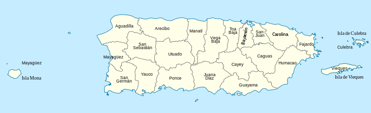
List of proposed municipalities
The 20 new municipalities of the 2009 amalgamation proposal (in bold) and the existing municipalities that would have made them up:
- North Puerto Rico
- South Puerto Rico
- East Puerto Rico
- Caguas: Caguas, Aguas Buenas, Gurabo, Juncos, San Lorenzo
- Carolina: Carolina, Canóvanas, Loíza, Río Grande
- Fajardo: Fajardo, Ceiba, Culebra, Luquillo, Vieques
- Humacao: Humacao, Las Piedras, Maunabo, Naguabo, Yabucoa
- West Puerto Rico
Notes
- WAPA-TV (2014; in Spanish) "El informe sobre la medida señala que al presente los municipios arrastran una deuda agregada de aproximadamente $590 millones [...]"[18]
References
- Sánchez Martínez, Héctor (October 10, 2012). "Puerto Rico: la isla de los 900 barrios". La Perla del Sur (in Spanish) (1506). p. 36.
- An Act: To amend Sections 1 and 2 of Act No. 100 of June 27, 1956 Act No. 81 of August 30, 1991: Autonomous Municipalities Act of the Commonwealth of Puerto Rico. In An Act: To amend Sections 1 and 2 of Act No. 100 of June 27, 1956, Act No. 66, 3rd Session of the 13th Legislature of Puerto Rico. April 14, 1998. Retrieved November 22, 2009.
- Historia de Nuestros Barrios: Portugués, Ponce. Rafael Torrech San Inocencio. El Sur a la Vista. elsuralavista.com. 14 February 2010. Accessed 12 February 2011.
- Ponce. Proyecto Salon Hogar. Map of Barrios of Ponce. (Map with fully urbanized barrios conglomerated and merged as "Zona Urbana". Barrio not labeled is named "Machuelo Abajo".) Retrieved November 30, 2009.
- "Ponce: General Information." Archived 2012-07-07 at the Wayback Machine Puerto Rico Encyclopedia. Retrieved November 30, 2009.
- Ponce Puerto Rico. AreciboWeb. (Map showing the 31 geo-numbered barrios of Ponce.) Retrieved November 30, 2009.
- Un Acercamiento Sociohistorico y Linguistico a los Toponimos del Municipio de Ponce, Puerto Rico. Amparo Morales, María T. Vaquero de Ramírez. "Estudios de lingüística hispánica: homenaje a María Vaquero". Page 113. Retrieved 19 July 2011.
- Cartographic Boundary Files. U. S. Census Bureau. Retrieved 1 December 2011.
- AREAS IN PUERTO RICO ELIGIBLE FOR RURAL HOUSING LOANS: BARRIOS, TOWNS AND VILLAGES. Archived 2014-05-31 at the Wayback Machine U.S. Department of Agriculture. Rural Development. Page 8. 2 June 2010. Retrieved 21 October 2012.
- "EPA County FIPS Code Listing". EPA.gov. Archived from the original on 2013-07-21. Retrieved 2008-02-23.
-
"U.S. Census Bureau". Retrieved July 26, 2013. - "U.S. Census Bureau geography". Retrieved August 31, 2011.
- El Morro. United States National Park Service. Accessed 6 October 2019.
- "2010 Census". Medgar Evers College. Archived from the original on 2010-06-11. Retrieved 2010-04-13.
- US Census Bureau: Table QT-P10 Hispanic or Latino by Type: 2010 retrieved January 22, 2012 - select state from drop-down menu
- United States Census
- Vázquez, Brenda (November 16, 2012). "Extensa la lista de los municipios con déficit". Metro Puerto Rico (in Spanish). Metro International. Retrieved September 29, 2013.
- "Nace la Corporación de Financiamiento Municipal" (in Spanish). WAPA-TV. January 23, 2014. Retrieved February 20, 2014.
- "Indicadores Socioeconómicos Municipales" (in Spanish). Puerto Rico Ombudsman. August 12, 2013. Archived from the original on 2013-09-25. Retrieved September 29, 2013.
- Legislador propone reducir a 20 los 78 municipios de Puerto Rico en PrimeraHora.com (In Spanish)
- Los municipios autónomos llegan a la mayoría de edad (documento). Cristina del Mar Quiles. Noticel. 3 June 2012. Retrieved 28 June 2012.
- Historia de Nuestros Barrios: Barrio Lapa, Salinas. Page 4. Retrieved 13 February 2011.
- Guayanilla. Encyclopedia Puerto Rico. Archived 2010-12-15 at the Wayback Machine Retrieved April 28, 2010.
- Historia de Nuestros Barrios: Lapa, Salinas. Accessed February 13, 2011.
- Líderes legislativos ponen freno a la eliminación de municipios. Nydia Bauzá. Primerahora.com 31 July 2017. 31 July 2017.
- Puerto Rico governor to introduce measure to consolidate Puerto Rico into Counties Maria Miranda. CaribbeanBusiness.com March 15, 2019
External links
| Wikimedia Commons has media related to Municipalities in Puerto Rico. |
- CIA World Factbook - Puerto Rico
- Municipalities on the west coast of Puerto Rico
- Diario de Puerto Rico official website
Puerto Rico articles | |||||||||
|---|---|---|---|---|---|---|---|---|---|
| History |
| ||||||||
| Geography |
| ||||||||
| Ecology |
| ||||||||
| Politics |
| ||||||||
| Economy |
| ||||||||
| Society |
| ||||||||
| |||||||||
Administrative divisions of the Americas | ||
|---|---|---|
| ||
| Sovereign states |
| .svg.png) |
Dependencies and other territories |
| |