Yang Chum Noi District
Yang Chum Noi (Thai: ยางชุมน้อย, pronounced [jāːŋ t͡ɕʰūm nɔ́ːj]) is a district (amphoe) in the northern part of Sisaket Province, northeastern Thailand.
Yang Chum Noi ยางชุมน้อย | |
|---|---|
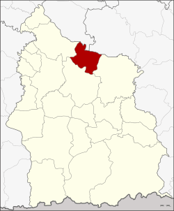 District location in Sisaket Province | |
| Coordinates: 15°15′42″N 104°24′4″E | |
| Country | Thailand |
| Province | Sisaket |
| Seat | Yang Chum Noi |
| Area | |
| • Total | 248.8 km2 (96.1 sq mi) |
| Population (2005) | |
| • Total | 36,991 |
| • Density | 191.2/km2 (495/sq mi) |
| Time zone | UTC+7 (ICT) |
| Postal code | 33180 |
| Geocode | 3302 |
Geography
Neighboring districts are (from the east clockwise): Kanthararom, Mueang Sisaket, and Rasi Salai of Sisaket Province; Kho Wang of Yasothon Province; and Khueang Nai of Ubon Ratchathani Province.
History
The minor district (king amphoe) Yang Chum Noi was established on 1 September 1971, when the three tambons, Yang Chum Noi, Khon Kam, and Lin Fa, were split off from Mueang Sisaket District.[1] On 25 March 1979 it was upgraded to a full district.[2]
Administration
The district is divided into seven sub-districts (tambons), which are further subdivided into 86 villages (mubans). Yang Chum Noi is a township (thesaban tambon) which covers parts of tambon Yang Chum Noi. There are a further seven tambon administrative organizations (TAO).
| No. | Name | Thai name | Villages | Pop. | |
|---|---|---|---|---|---|
| 1. | Yang Chum Noi | ยางชุมน้อย | 10 | 6,119 | |
| 2. | Lin Fa | ลิ้นฟ้า | 19 | 6,236 | |
| 3. | Khon Kam | คอนกาม | 14 | 5,795 | |
| 4. | Non Khun | โนนคูณ | 14 | 6,654 | |
| 5. | Kut Mueang Ham | กุดเมืองฮาม | 8 | 3,310 | |
| 6. | Bueng Bon | บึงบอน | 13 | 5,725 | |
| 7. | Yang Chum Yai | ยางชุมใหญ่ | 8 | 3,152 |
References
- ประกาศกระทรวงมหาดไทย เรื่อง แบ่งท้องที่อำเภอเมืองศรีสะเกษ จังหวัดศรีสะเกษ ตั้งเป็นกิ่งอำเภอยางชุมน้อย (PDF). Royal Gazette (in Thai). 88 (97 ง): 2483. September 7, 1971.
- พระราชกฤษฎีกาตั้งอำเภอหนองกุงศรี อำเภอไทรงาม อำเภอบ้านฝาง อำเภออุบลรัตน์ อำเภอเวียงชัย อำเภอดอยเต่า อำเภอนิคมคำสร้อย อำเภอนาหว้า อำเภอเสิงสาง อำเภอศรีสาคร อำเภอบึงสามพัน อำเภอนาดูน อำเภอค้อวัง อำเภอโพธิ์ชัย อำเภอเมืองสรวง อำเภอปลวกแดง อำเภอยางชุมน้อย อำเภอกาบเชิง อำเภอสุวรรณคูหา และอำเภอกุดข้าวปุ้น พ.ศ. ๒๕๒๒ (PDF). Royal Gazette (in Thai). 96 (42 ก Special): 19–24. March 25, 1979.