Phu Sing District
Phu Sing (Thai: ภูสิงห์, pronounced [pʰūː sǐŋ]) is a district (amphoe) in the southwestern part of Sisaket Province, northeastern Thailand.
Phu Sing ภูสิงห์ | |
|---|---|
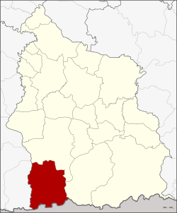 Amphoe location in Sisaket Province | |
| Coordinates: 14°32′48″N 104°7′54″E | |
| Country | Thailand |
| Province | Sisaket |
| Seat | Huai Tuekchu |
| Area | |
| • Total | 940.1 km2 (363.0 sq mi) |
| Population (2005) | |
| • Total | 50,585 |
| • Density | 53.8/km2 (139/sq mi) |
| Time zone | UTC+7 (ICT) |
| Postal code | 33140 |
| Geocode | 3317 |
History
The minor district (king amphoe) was created on 1 April 1991, when the six tambons Khok Tan, Huai Ta Mon, Huai Tuekchu, Lalom, Takhian Ram, and Dong Rak were split off from Khunkhan District.[1] It was upgraded to a full district on 8 September 1995.[2]
Geography
The district is bounded in the south by the Dangrek Range. Neighboring districts are (from the west clockwise): Buachet of Surin Province, Khukhan, and Khun Han of Sisaket Province, and Oddar Meancheay of Cambodia.
Administration
The district is divided into seven sub-districts (tambons), which are further subdivided into 85 villages (mubans). There are no municipal (thesaban) areas, and seven tambon administrative organizations (TAO).
| No. | Name | Thai name | Villages | Pop. | |
|---|---|---|---|---|---|
| 1. | Khok Tan | โคกตาล | 13 | 7,324 | |
| 2. | Huai Ta Mon | ห้วยตามอญ | 10 | 6,212 | |
| 3. | Huai Tuekchu | ห้วยตึ๊กชู | 18 | 11,313 | |
| 4. | Lalom | ละลม | 13 | 7,554 | |
| 5. | Takhian Ram | ตะเคียนราม | 14 | 5,928 | |
| 6. | Dong Rak | ดงรัก | 8 | 5,770 | |
| 7. | Phrai Phatthana | ไพรพัฒนา | 9 | 6,484 |
References
- ประกาศกระทรวงมหาดไทย เรื่อง แบ่งเขตท้องที่อำเภอขุขันธ์ จังหวัดศรีสะเกษ ตั้งเป็นกิ่งอำเภอภูสิงห์ (PDF). Royal Gazette (in Thai). 108 (15 ง): 1069. 31 January 1991.
- พระราชกฤษฎีกาตั้งอำเภอด่านมะขามเตี้ย อำเภอแก่งหางแมว อำเภอภักดีชุมพล อำเภอเวียงแก่น อำเภอแม่วาง อำเภอถ้ำพรรณรา อำเภอบ่อเกลือ อำเภอโนนสุวรรณ อำเภอห้วยราช อำเภอแม่ลาน อำเภอบางแก้ว อำเภอป่าพะยอม อำเภอหนองม่วงไข่ อำเภอยางสีสุราช อำเภอจังหาร อำเภอบ้านธิ อำเภอภูสิงห์ อำเภอบางกล่ำ อำเภอวังม่วง และอำเภอนายูง พ.ศ. ๒๕๓๘ (PDF). Royal Gazette (in Thai). 112 (32 ก): 1–3. 8 August 1995.