Lea Bridge
Lea Bridge is a district in the London Borough of Hackney and the London Borough of Waltham Forest in London, England. It lies 7 miles (11.3 km) northeast of Charing Cross.
| Lea Bridge | |
|---|---|
 Below Lea Bridge, the flow of the river continues over the head of the Middlesex Filter Beds Weir. Hackney Cut continues the navigation to the right. The island between contains a nature reserve in the former filter beds. | |
 Lea Bridge Location within Greater London | |
| Population | 29,710 (Both Lea Bridge wards 2011 Census)[1] |
| OS grid reference | TQ355865 |
| • Charing Cross | 7 mi (11.3 km) SW |
| London borough | |
| Ceremonial county | Greater London |
| Region | |
| Country | England |
| Sovereign state | United Kingdom |
| Post town | LONDON |
| Postcode district | E5, E10 |
| Dialling code | 020 |
| Police | Metropolitan |
| Fire | London |
| Ambulance | London |
| UK Parliament | |
| London Assembly | |
The area it takes its name from a bridge built over the River Lea in 1745, and the Lea Bridge Road which leads through the area and across the bridge. The bridge also gives its name to a ward in Waltham Forest (Lea Bridge) on the eastern, Leyton, bank of the river.
Within Hackney, Lea Bridge Road forms the customary boundary between Upper and Lower Clapton.
History
In 1582 Mill Fields Lane ran from Clapton to Jeremy's Ferry in the Leyton Marshes. At the same spot a timber bridge was built in 1745, and the road became known as Lea Bridge Road, with a tollgate at the Clapton end.[2] A toll house was built on the west bank of the river in 1757, and the bridge rebuilt in iron in 1820–1. Tolls continued to be levied until 1872.
Clapton Orient played at the Lea Bridge Stadium between 1930 and 1937 before moving to Brisbane Road. The stadium was also used for speedway and was the home track of the Lea Bridge speedway team.
Local area
There are few crossing points for the Lea Marshes. The nearest major river crossing to the south is at Hackney Wick and to the north at Tottenham Hale.
The area contains large amounts of open space, dominated by Millfields recreation grounds, south of which is the site of the coal-fired Millfields power station, now disused except as a sub-station. This was built in 1901, well before the creation of the National Grid in 1938, a period when power had to be generated near to the consumer. It provided electric street lighting throughout the then Metropolitan Borough of Hackney.
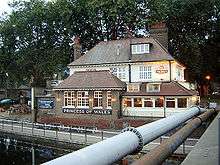
Lea Bridge gives ready access to the lower reaches of the extensive Lee Valley Park, which stretches for about 42 kilometres (26.1 mi) on both banks of the river. Next to the south side of the bridge are two public houses, the "Princess of Wales" and "The Ship Aground". To the south are the Hackney Marshes, and beyond Leyton Marsh to the north are the Walthamstow Marshes and Nature Reserve. Below the bridge, the river flows over the Middlesex Filter Beds Weir, marking the boundary with Leyton and providing the supply for the former East London Waterworks Company. The old Middlesex Filter Beds have been converted into a nature reserve, and on the Leyton side the corresponding Essex Filter Beds are now a reserve for birds. The Lee Navigation continues south in an artificial channel known as 'Hackney Cut', to the next lock at Old Ford (about 1.7 miles), where the natural channel rejoins the Navigation after its 2 miles (3.2 km) meander towards Leyton.
Geography
Neighbouring areas of London | ||||||||||
|---|---|---|---|---|---|---|---|---|---|---|
| ||||||||||
Education
Transport
.jpg)
The local station for Lea Bridge is Lea Bridge railway station on the Lea Valley lines. Lea Bridge Road is well served by buses having eight bus routes in total, two of which are night routes, and one 24-hour route. Buses in the area include routes 48, 55, 56, 58 and W19, with the addition of night routes N38, N55 and 24-hour operated route 158.[3]
References
- "Waltham Forest Ward population 2011". Neighbourhood Statistics. Office for National Statistics. Retrieved 19 October 2016.
- 'Hackney: Communications', A History of the County of Middlesex: Volume 10: Hackney (1995), pp. 4-10 Date accessed: 1 November 2006
- "Buses from Lea Bridge Road" (PDF). Transport for London. Retrieved 30 April 2019.
External links
- Lee Valley Park
- Lea Bridge Road Nature Reserves Leaflet (PDF)
- Lea Bridge Road Nature Reserves Map (PDF)
- The River Lee (for young people)

| Districts |
|  |
|---|---|---|
| Attractions |
| |
| Street markets | ||
| Parks and open spaces |
| |
| Constituencies |
| |
| Tube and rail stations | ||
| Other topics | ||
| ||