Erith
Erith (/ˈɪərɪθ/ (![]()
| Erith | |
|---|---|
 William Cory Promenade along the River Thames frontage and Riverside Gardens | |
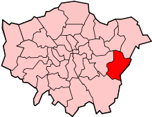
 Erith Location within Greater London | |
| Population | 45,345 (2011 Census)[1] |
| OS grid reference | TQ505775 |
| • Charing Cross | 13.3 mi (21.4 km) WNW |
| London borough | |
| Ceremonial county | Greater London |
| Region | |
| Country | England |
| Sovereign state | United Kingdom |
| Post town | ERITH |
| Postcode district | DA8 |
| Dialling code | 01322 |
| Police | Metropolitan |
| Fire | London |
| Ambulance | London |
| UK Parliament | |
| London Assembly | |
Erith town centre has undergone modernisation and an increase in dwellings since 1961. The curved riverside high street contains three listed buildings, including the Church of England church and the Carnegie Building, while the district otherwise consists primarily of suburban homes. Erith is linked to central London and Kent by rail, and a dual carriageway links it to Thamesmead. It has the longest pier in London, and retains a coastal environment with salt marshes as well as industrial land.
History
Pre-medieval
Work carried out at the former British Gypsum site in Church Manorway by the Museum of London Archaeological Service shows that the area was covered by a dense forest of oak, yew, and alder during the Neolithic Period, which by the Bronze Age had given way in part to sedge fen.[2]
The museum's work at the former site of Erith School in Belmont Road revealed traces of prehistoric settlement, and of a substantial community or farmstead in the first century AD.[3]
Anglo-Saxons
Following the collapse of Roman rule at the beginning of the 5th century, Britain was colonised by Anglo-Saxon invaders from northern Europe. The Anglo-Saxon Chronicle records that they won the Battle of Crecganford (thought to be modern Crayford) in 457 and shortly after claimed the whole of Kent. Their different way of life was reflected in their pattern of settlement. The town and country estates of the Roman bureaucrats gave way to a network of villages, occupied by warriors and farmers. Erith was one such village and has a Saxon name, originally Ærre hyðe meaning "old haven".[4]
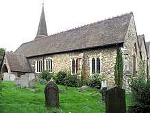
There was probably a church on the site of the present St John the Baptist's during the Anglo-Saxon period.[5] The early settlement was based around it, meaning that the centre of Erith was once west of its current location.
Medieval
The earliest reference to the area is in a Latin charter of 695 recording a grant by the Bishop of the East Saxons of certain lands at Erith. The surrounding area was known as Lesnes or Lessness, which is mentioned in the Domesday Survey. After the Norman Conquest, Lessness passed into the possession of Bishop Odo.[6] In 1315, a Royal Charter was granted for a market to be held in Erith every Thursday. However, it was noted in 1776 that the market had long been discontinued.[7]
Erith owes its existence to the Thames and was, until the 1850s, essentially a small riverside port, given prominence by King Henry VIII's decision to open a naval dockyard there, approximately where the Riverside Gardens are now. Henry's famous warship, Henri Grâce à Dieu, was fitted out there in 1515.[8]
Following the death of George Talbot, 4th Earl of Shrewsbury in 1538, Erith 'alias Lysnes' was granted to his widow, Elizabeth, by Henry VIII 'with all its members and appurtenances, to hold in capite, by knight's service.'[9]
Up until the 19th century Erith remained a popular anchorage. Ships often discharged some cargo there to reduce their displacement before entering the shallows upstream.
Industrial era
In 1797 Edward Hasted described Erith as "consisting of one small street of houses, which leads to the water side", and mentions two annual fairs, at Ascension and Michaelmas.[10] In 1831 Erith's population was 1533 – it was described in 1840 as being "composed chiefly of two streets, one leading down to the water side, the other branching off to the left towards the church."[11]
By 1849 Erith was enjoying a short spell as a riverside resort. Its pier and nearby hotel gave hospitality for day-trippers arriving on Thames pleasure boats or by railway.[8]
The Local Government Act 1894 brought into existence Erith Urban District, which became the Municipal Borough of Erith in 1938. It included Northumberland Heath and Belvedere.
Erith Iron Works was established in 1864 on a riverside site at Anchor Bay, east of Erith's centre, by William Anderson.[12]
From 1881 an area northwest of Erith's centre was home to a large cable works founded by William Callender. This became British Insulated Callender's Cables (BICC), and eventually Pirelli, which announced its partial closure in 2003. The remainder became Prysmian.
20th century
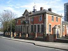
The town's first library, designed by local architect William Egerton, and funded by philanthropist Andrew Carnegie, opened in 1906.[13]
Engineering became an important industry around Erith, with armaments and cables being the main products. Vickers was a major employer and was linked to the Royal Arsenal at nearby Woolwich.[8]
During the First World War Erith was an important area for the manufacture of guns and ammunition, largely due to the presence of the large Vickers works.
The town suffered heavy bomb damage in the Second World War, mainly due its position on the riverside near the Royal Arsenal. The bomb damage and a gradual decline in local trade prompted major redevelopment in the 1960s.[8]
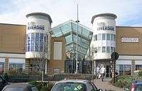
In 1961, plans were put forward to redevelop Erith into a modern, sleek shopping and working environment. This involved clearing the sub-standard housing by the riverside and altering the street layout. Some of the buildings erected, particularly the social housing tower blocks, are of a brutalist form that typified the overspill estates put up by almost all councils in England's major cities as an affordable way of clearing the slums.[14]
In 1965, under the London Government Act 1963, Erith became part of the London Borough of Bexley.
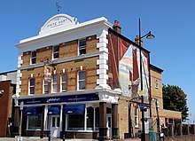
Demolition of the old town started in 1966 and continued in phases until 1980, leaving only a few reminders of the old town centre. Many of the original Victorian buildings were lost, but some of the original townscape remains, including the White Hart in the High Street and St John's Church in West Street.[8]
Erith is the site of the Erith Oil Works, originally British Oil & Cake Mills (BOCM). It now processes various seeds into vegetable oils.

Regeneration
Since the late 1990s Erith has been undergoing significant changes, with the Erith Western Thames Gateway[15] project being the culmination. The regeneration falls within the remit of the Thames Gateway project, with Erith as a key focus[16] for Bexley Council, as its only population centre on the River Thames.
Since 2000 a significant number of new flats have been constructed by the river by private developers. The Erith Western Gateway will include riverside flats,[17] and is expected to continue the regeneration of the area, hitherto a large underused area of the town centre. Bexley Council is seeking to produce a mixed-use development with a potential of 6,000 sq.m of new commercial space and over 500 new homes.[17]
In 2020, local campaigners secured National Lottery funding to restore the former library building to provide new community facilities.[18]
Geography
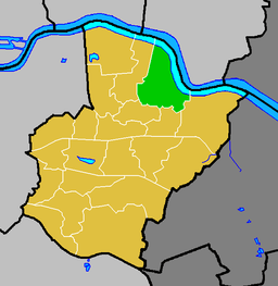
Erith is a post town in the DA postcode area, consisting of the DA8 and DA18 postcode districts. It borders the River Thames to the north, Slade Green to the east and south east, Northumberland Heath to the south and south west and Belvedere to the west and north west.
Neighbouring towns, villages and places. | ||||||||||
|---|---|---|---|---|---|---|---|---|---|---|
| ||||||||||
Demography
62% of the population is White British, according to the 2011 census, down from 82% in 2001 and 89% in 1991. The second most common ethnicity is Black African, at 14%.[19]
The proportion of Erith's population identifying as White Gypsy or Irish Traveller is far higher than the national average, at 0.74% of the population. According to the 2011 Census, this is the 131st highest out of the 8,560 wards in England.
The median house price in Erith ward was £181,000 in 2014. This is the third lowest out of the 628 wards in Greater London, with only neighbouring Belvedere and the Abbey ward of Barking and Dagenham having lower prices.[20]
Representation
A large part of Erith is in the Erith ward of the London Borough of Bexley. The local councillors are Joe Ferreira (Labour) and Nicola Taylor (Labour).[21] The eastern part of Erith is in North End ward, and the southern part in Colyers ward.
Most of Erith lies within the Erith and Thamesmead constituency. The current Member of Parliament is Teresa Pearce (Labour). The eastern part of Erith is within the Bexleyheath and Crayford constituency, whose MP is David Evennett (Conservative).
Erith is in the Bexley and Bromley London Assembly constituency and is represented on the London Assembly by Gareth Bacon (Conservative).
Amenities
- For education in Erith see the main London Borough of Bexley article
Erith Leisure Centre, including swimming facilities, was opened in 2005.[22]
The David Ives Stadium is next to the Leisure Centre. It is often called Erith Stadium and is home to Bexley Athletic Club.[23][24]
The Erith Playhouse Theatre is the largest in Bexley.[25]
Erith has a Health Centre and a library with a meeting room.
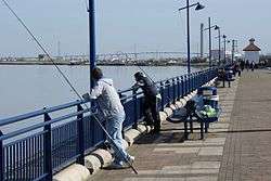
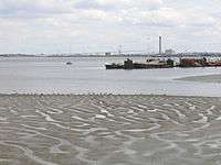
Erith is the location of the longest pier in Greater London. The pier has recently been adapted from commercial to leisure use, and is popular with anglers.
The annual Erith Riverside Festival has been held for a number of years in Riverside Gardens alongside the Thames. Erith is the starting point for the LOOP (London Outer Orbital Path) and one of the starting points for the Green Chain Walk.[26] The Thames Path National Trail,[27] which runs to the source of the River Thames at Kemble, begins at nearby Crayford Ness.
Erith Rowing Club is located on the Erith waterfront. Erith Yacht Club is based a short distance downstream from Erith on the edge of Crayford Marshes.
There are two senior football clubs named for Erith, neither of which are actually based in the town. Erith & Belvedere play at Park View Road in Welling, and Erith Town play at Oakwood in Crayford.
Notable people
- Philip Absolon (1960–), Stuckist artist, was born in Erith
- Ronnie Aldrich (1916–93), jazz pianist and band-leader, was born in Erith[28]
- Patrick Young Alexander (1867–1943), aeronautical pioneer, born in Erith or Belvedere
- William Auld (1924–2006), Scottish poet, author and Esperantist, born in Erith[29]
- Sir William Anderson (1834–98), engineer and philanthropist, lived in Erith from 1864 until 1889 and contributed substantial time and money to the local community[30]
- Tony Brise (1952–75), motor racing driver, born in Erith[31]
- Wendy Cope (1945–), poet, born in Erith[32]
- John Downton (1906–1991), artist, poet and philosopher, born in Erith[33]
- Kevin Horlock (1972–), footballer, Northern Ireland international, born in Erith[34]
- Bill Jaques (1888–1925), footballer, born in Erith[35]
- James Leasor (1923–2007), journalist and author[36]
- Dave Martin (1985–), footballer, born in Erith[37]
- Douglas McWhirter (1886–1966), amateur footballer, part of the gold-medal winning English team at the 1912 Summer Olympics, born in Erith[38]
- Percy Hilder Miles (1878–1922), professor, violinist and composer, was born in Erith[39]
- Alan Morton (1950–), footballer, born in Erith[40]
- Robert Napper (1966–), serial murderer and rapist, born in Erith[41]
- Anthony Reckenzaun (1850–93), the 19th century engineer, worked at the Erith Ironworks and set up evening classes for the workmen[42]
- Steve Rutter (1968–), footballer, born in Erith
- Sam Saunders (1983–), footballer (Brentford F.C.), born in Erith[43]
- Linda Smith (1958-2006), comedian and writer, came from Erith.[44] Smith famously joked that Erith was not twinned with any town but did have a suicide pact with Dagenham.
- Jim Sterling (1984–), video game journalist, born and grew up in Erith[45]
- Denis Thatcher, husband of Prime Minister Margaret Thatcher, headed the family-owned Atlas Preservatives, based in Erith, until 1965[46][47]
- Henry Wheatley (1777–1852), keeper of the privy purse for King William IV and Queen Victoria from 1830 to 1846, born and grew up at Lesney House[48]
A rhyme by William Cosmo Monkhouse:
- "There are men in the village of Erith that nobody seeth or heareth,
- and there looms on the marge of the river a barge, that nobody roweth or steereth".[49]
Places of worship
- Barnehurst Methodist Church, Erith
- Christ Church, Victoria Rd. Erith
- Christadelphian Hall, Lesney Park Rd. Erith
- Northend Baptist Church, Larner Rd, Erith
- Northumberland Road Baptist Church, Belmont Road, Erith
- Our Lady of the Angels Church, Carlton Road, Erith
- Queen Street Baptist Church, Erith
- St. Augustines Church (Slade Green), Slade Green Rd, Erith
- St. Johns the Baptist Church, West Street, Erith
- St. Paul's Church, Mill Road, Erith
- The Treasure House, Bexley Road, Erith
Transport

Buses
Erith is served by London Buses routes 99, 229, 428, 469, B12 and N89.
Rail
The nearest station is Erith for Southeastern services towards Dartford, Gillingham, Gravesend, London Cannon Street and London Charing Cross.
Slade Green railway station is on the same line and serves the eastern part of the town.
Road
The A2016 road bisecting Erith, is a dual carriageway stretching across the Erith Marshes.
References
- Erith is made up of 4 wards in the London Borough of Bexley: Colyers, Erith, North End, and Northumberland Heath. "Archived copy". Archived from the original on 22 February 2014. Retrieved 9 June 2014.CS1 maint: archived copy as title (link)
- Museum of London summary of archaeological work carried out in 2001 Archived 15 May 2005 at the Wayback Machine accessed 6 April 2008
- Museum of London summary of archaeological work carried out in 1996 Archived 25 March 2005 at the Wayback Machine accessed 6 April 2008
- Hasted, Edward. "'Parishes: Erith', in The History and Topographical Survey of the County of Kent: Volume 2". British History Online. Canterbury. pp. 227–263. Archived from the original on 2 January 2016. Retrieved 1 January 2016.
- Good Stuff IT Services (20 May 1953). "Parish Church of St John the Baptist – Bexley – Greater London – England". British Listed Buildings. Archived from the original on 26 January 2012. Retrieved 24 August 2012.
- "The Bexley Area in the Domesday Book". Bexley borough council. Archived from the original on 1 July 2016. Retrieved 11 February 2017.
- Bexley Local Studies Note 51 – Historical References to Erith Market accessed 6 June 2008
- "History of Erith | History of Bexley and Districts". Ideal Homes. Retrieved 24 August 2012.
- Hasted, Edward (1797). The History and Topographical Survey of the County of Kent. Canterbury: W. Bristow. pp. 227–263. Archived from the original on 2 January 2016.
- "Parishes: Erith - British History Online". www.british-history.ac.uk. Archived from the original on 3 September 2014. Retrieved 7 May 2018.
- "RootsWeb.com Home Page". freepages.genealogy.rootsweb.com. Archived from the original on 5 February 2008. Retrieved 7 May 2018.
- Bexley Local Studies Note 66 'Sir William Anderson' accessed 6 June 2008
- Murphy, Chris (21 March 2019). "Calls for help to save Erith's Old Library building". Bexley Times. Retrieved 6 March 2020.
- Urban regeneration: the essentials Archived 19 April 2013 at the Wayback Machine The Guardian
- Archived 7 October 2008 at the Wayback Machine
- "London – Places – Why Thames Gateway is good for Bexley". BBC. 15 May 2008. Archived from the original on 10 November 2012. Retrieved 24 August 2012.
- "Erith Western Gateway". Retrieved 17 September 2007.
- Bennett-Ness, James (27 February 2020). "Old Library in Erith with fascinating history to be fully restored thanks to Bexley residents". News Shopper. Retrieved 6 March 2020.
- Services, Good Stuff IT. "Erith - UK Census Data 2011". UK Census Data. Archived from the original on 20 September 2016. Retrieved 7 May 2018.
- https://data.london.gov.uk/dataset/ward-profiles-and-atlas
- "Erith Councillors". London Borough of Bexley. Retrieved 8 July 2018.
- "Archived copy". Archived from the original on 27 February 2017. Retrieved 27 February 2017.CS1 maint: archived copy as title (link)
- "Training - Bexley Athletic Club". www.bexleyac.org.uk. Archived from the original on 8 May 2018. Retrieved 7 May 2018.
- "Erith Stadium". Runtrackdir.com. 31 March 2005. Retrieved 24 August 2012.
- "Erith Playhouse". Playhouse.org.uk. 21 January 2012. Archived from the original on 29 July 2012. Retrieved 24 August 2012.
- "Explore South East London's Green Chain". Greenchain.com. Archived from the original on 25 September 2000. Retrieved 24 August 2012.
- Ramblers. "Thames Path National Trail | Paths by name | Ramblers, Britain's Walking Charity". Ramblers.org.uk. Archived from the original on 28 September 2008. Retrieved 24 August 2012.
- "Surnames beginning with A". bexley.gov.uk. Archived from the original on 9 June 2016. Retrieved 13 November 2016.
- "William Auld". The Scotsman. 15 September 2006. Archived from the original on 26 November 2016. Retrieved 25 November 2016.
- "Sir William Anderson, 1834–1898". bexley.gov.uk. Archived from the original on 24 November 2016. Retrieved 23 November 2016.
- "Tony Brise". historicracing.com. Archived from the original on 24 November 2016. Retrieved 23 November 2016.
- Lewis, Helen (3 December 2011). "Wendy Cope interview: "I can't die until I've sorted out the filing cabinets"". The New Statesman. Archived from the original on 24 November 2016. Retrieved 23 November 2016.
- "Awards entry catches the eye". Kent Online. 19 November 2012. Archived from the original on 24 November 2016. Retrieved 23 November 2016.
- "Chatham Town unveil former Manchester City midfielder Kevin Horlock, 42, as their new manager". Kentish Football. 15 October 2015. Archived from the original on 5 March 2017. Retrieved 25 November 2016.
- Joyce, Michael (2004). Football League Players' Records. soccerdata. p. 137. ISBN 1-899468-63-3.
- Adrian, Jack (22 December 2007). "James Leasor: Journalist and thriller writer". The Independent. Archived from the original on 24 November 2016. Retrieved 23 November 2016.
- Hugman, Barry J., ed. (2009). The PFA Footballers' Who's Who 2009–10. Mainstream Publishing. ISBN 978-1-84596-474-0.
- "Douglas McWhirter bio, stats and results". sports-reference.com. Archived from the original on 3 December 2016. Retrieved 25 November 2016.
- Musical Times through Google Books. 37. 1 February 1896. p. 98. Retrieved 7 February 2011.
- "Players: Alan Morton". The Historical Don. Archived from the original on 26 November 2016. Retrieved 25 November 2016.
- Hughes, Mark (19 December 2008). "Rachel Nickell: Six mistakes in hunt for serial killer". The Independent. Archived from the original on 26 November 2016. Retrieved 25 November 2016.
- "Anthony Reckenzaun - Graces Guide". www.gracesguide.co.uk. Retrieved 4 May 2020.
- Rollin, Glenda; Rollin, Jack, eds. (2012). Sky Sports Football Yearbook 2012–2013 (43rd ed.). London: Headline. p. 439. ISBN 978-0-7553-6356-8.
- "Linda Smith – Obituary". The Daily Telegraph. 1 March 2006. Archived from the original on 14 November 2016. Retrieved 13 November 2016.
- Jim Sterling (11 April 2012). "Beautifully bleak, a quasi-defense of "dark and gritty" games". gamefront.com. Archived from the original on 24 November 2016. Retrieved 23 November 2016.
- "Surnames beginning with T". bexley.gov.uk. Archived from the original on 14 November 2016. Retrieved 23 November 2016.
- Christopher Winn: I Never Knew That about the Thames (London: Ebury Press, 2010).
- "The Wheatley's Housekeeper's accounts, 1792–1817". bexley.gov.uk. Archived from the original on 15 February 2016. Retrieved 25 November 2016.
- Nonsense Rhymes, Cosmo Hamilton, R. Brimley Johnson, London, 1900
External links
| Wikimedia Commons has media related to Erith. |
- erithtown.net – an introduction and guide to Erith, with comprehensive directory
- North West Kent Family History Society – Erith Parish Page
| Districts |
|  |
|---|---|---|
| Attractions |
| |
| Parks and open spaces | ||
| Constituencies | ||
| Rail stations | ||
| Other topics | ||
| ||
| Principal officers |
|  |
|---|---|---|
| Subsidiary boards | ||
| Resident Commissioners of the navy home yards |
| |
| Resident Commissioners of the navy overseas yards |
| |
| Offices under the principal officers |
| |