Derry Township, Westmoreland County, Pennsylvania
Derry Township is a township in Westmoreland County, Pennsylvania, in the United States. It surrounds the Borough of Derry, which is a separate municipality. As of the 2000 census, the township population was 14,726.
Derry Township, Westmoreland County, Pennsylvania | |
|---|---|
 Keystone State Park is in Derry Township | |
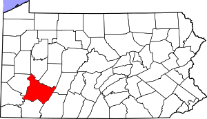
 Map of Westmoreland County, Pennsylvania Highlighting Derry Township | |
 Map of Pennsylvania highlighting Westmoreland County | |
| Country | United States |
| State | Pennsylvania |
| County | Westmoreland |
| Settled | 1763 |
| Incorporated | 1775 |
| Named for | Derry |
| Area | |
| • Total | 96.28 sq mi (249.37 km2) |
| • Land | 95.09 sq mi (246.29 km2) |
| • Water | 1.19 sq mi (3.08 km2) |
| Population (2010) | |
| • Total | 14,502 |
| • Estimate (2018)[2] | 13,944 |
| • Density | 148.36/sq mi (57.28/km2) |
| Time zone | UTC-5 (Eastern (EST)) |
| • Summer (DST) | UTC-4 (EDT) |
| FIPS code | 42-129-18968 |
| Website | http://www.derrytownship.com |
It was named after the city of Derry by Scotch-Irish settlers.
History
The first settlements in Derry township were created by soldiers from Forbes' army in 1762. After hearing of the land being settled by soldiers from Forbes' army, John Pomroy, a man of Scots-Irish descent, left his home in Cumberland valley and settled in Derry township, near present day New Derry. Later, James Wilson came and settled near by and they helped one another build and farm. One winter, a few years after settling in Derry township, Pomroy and Wilson returned to their homes in the East. When they returned, each brought with him a wife. Pomroy married Isabel Barr. Later, her father and two of her brothers, along with William Guthrie and Richard Wallace and others migrated to Derry township.[3]
To protect the citizens of Derry township from Indian attacks, Fort Barr and Fort Wallace were built in 1774. Other dangers that early settlers faced included bears, panthers, and foxes.[3]
John Frederick Pershing; father of John J "Black Jack" Pershing, General of the Armies was born in Derry on March 1, 1834.
The Bear Cave is a natural maze of caverns. Some 8,500 feet of passages have been mapped and it has become a popular recreational site. After 1839, accounts of the Bear Cave began to appear in local newspapers.[4]
Keystone State Park was established in 1945.
The Samuel Patterson House was added to the National Register of Historic Places in 1985.[5]
Geography
According to the United States Census Bureau, the township has a total area of 97.4 square miles (252 km2), of which, 95.8 square miles (248 km2) of it is land and 1.5 square miles (3.9 km2) of it (1.56%) is water.
The township contains the following communities: Andrico, Andrico No. 2, Atlantic, Bairdstown, Bradenville, Brenizer, Hillside, Loyalhanna, Cokeville Heights, Cooperstown, Kingston, Mannitto Haven, McChesneytown, Millwood, New Derry, Osburn, Pandora, Peanut, Seger, Snydertown, Superior, Torrance, and West Derry.
The villages of Livermore and Cokeville no longer exist, relocated as part of the Conemaugh Dam Flood Control project.
Demographics
| Historical population | |||
|---|---|---|---|
| Census | Pop. | %± | |
| 2000 | 14,726 | — | |
| 2010 | 14,502 | −1.5% | |
| Est. 2018 | 13,944 | [2] | −3.8% |
| U.S. Decennial Census[6] | |||
As of the census[7] of 2000, there were 14,726 people, 5,716 households, and 4,201 families residing in the township. The population density was 153.6 people per square mile (59.3/km2). There were 6,200 housing units at an average density of 64.7/sq mi (25.0/km2). The racial makeup of the township was 98.21% White, 1.18% African American, 0.14% Asian, 0.03% Native American, 0.01% Pacific Islander, 0.05% from other races, and 0.37% from two or more races. Hispanic or Latino of any race were 0.47% of the population.
There were 5,716 households, out of which 29.8% had children under the age of 18 living with them, 58.9% were married couples living together, 10.1% had a female householder with no husband present, and 26.5% were non-families. 23.2% of all households were made up of individuals, and 11.0% had someone living alone who was 65 years of age or older. The average household size was 2.48 and the average family size was 2.91.
In the township the population was spread out, with 22.2% under the age of 18, 6.7% from 18 to 24, 28.3% from 25 to 44, 26.0% from 45 to 64, and 16.7% who were 65 years of age or older. The median age was 41 years. For every 100 females, there were 97.9 males. For every 100 females age 18 and over, there were 94.8 males.
The median income for a household in the township was $34,208, and the median income for a family was $40,878. Males had a median income of $32,589 versus $22,147 for females. The per capita income for the township was $16,425. About 8.3% of families and 10.1% of the population were below the poverty line, including 14.5% of those under age 18 and 5.5% of those age 65 or over.
References
- "2016 U.S. Gazetteer Files". United States Census Bureau. Retrieved Aug 14, 2017.
- Bureau, U. S. Census. "U.S. Census website". United States Census Bureau. US Census Bureau. Retrieved 1 December 2019.
- Boucher, John Newton (1906). History of Westmoreland county, Pennsylvania. New York: The Lewis Publishing Company. pp. 537-540.
- "Mid-Atlantic Karst Conservancy, Inc". www.karst.org. Retrieved 2018-10-26.
- "National Register Information System". National Register of Historic Places. National Park Service. July 9, 2010.
- "Census of Population and Housing". Census.gov. Retrieved June 4, 2016.
- "U.S. Census website". United States Census Bureau. Retrieved 2008-01-31.
External links
Pittsburgh metropolitan area | ||
|---|---|---|
| Counties |  Map of the Pittsburgh Tri-State with green counties in the metropolitan area and yellow counties in the combined area. | |
| Major cities | ||
| Cities and towns 15k–50k (in 2010) | ||
| Airports | ||
| Topics | ||
| ||
| Authority control |
|
|---|