East Vandergrift, Pennsylvania
East Vandergrift is a borough in Westmoreland County in the U.S. state of Pennsylvania. The population was 674 at the 2010 census.
East Vandergrift, Pennsylvania | |
|---|---|
Borough | |
 Houses on McKinley Avenue | |
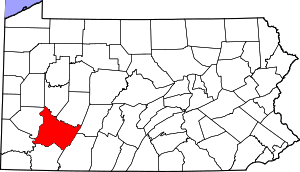
 Location of East Vandergrift in Westmoreland County, Pennsylvania. | |
 East Vandergrift, Pennsylvania Location of East Vandergrift in Westmoreland County, Pennsylvania. | |
| Coordinates: 40°35′54″N 79°33′43″W | |
| Country | United States |
| State | Pennsylvania |
| County | Westmoreland |
| Incorporated | December 18, 1901 |
| Government | |
| • Type | Borough council |
| • Mayor | Barbara Sharp |
| Area | |
| • Total | 0.14 sq mi (0.38 km2) |
| • Land | 0.13 sq mi (0.33 km2) |
| • Water | 0.02 sq mi (0.05 km2) |
| Elevation | 814 ft (248 m) |
| Population (2010) | |
| • Total | 674 |
| • Estimate (2018)[2] | 637 |
| • Density | 5,087.30/sq mi (1,961.82/km2) |
| Time zone | UTC-5 (Eastern (EST)) |
| • Summer (DST) | UTC-4 (EDT) |
| Zip code | 15629 |
| FIPS code | 42-21976 |
| Website | Official borough website |
Geography
East Vandergrift is located at 40°35′54″N 79°33′43″W (40.598412, -79.561964).[3]
According to the United States Census Bureau, the borough has a total area of 0.1 square miles (0.26 km2), of which, 0.1 square miles (0.26 km2) of it is land and 0.04 square miles (0.10 km2) of it (14.29%) is water.
Demographics
| Historical population | |||
|---|---|---|---|
| Census | Pop. | %± | |
| 1910 | 1,852 | — | |
| 1920 | 1,989 | 7.4% | |
| 1930 | 2,441 | 22.7% | |
| 1940 | 2,005 | −17.9% | |
| 1950 | 1,665 | −17.0% | |
| 1960 | 1,388 | −16.6% | |
| 1970 | 1,151 | −17.1% | |
| 1980 | 955 | −17.0% | |
| 1990 | 787 | −17.6% | |
| 2000 | 742 | −5.7% | |
| 2010 | 674 | −9.2% | |
| Est. 2018 | 637 | [2] | −5.5% |
| Sources:[4][5][6] | |||
At the 2000 census there were 742 people, 333 households, and 204 families living in the borough. The population density was 6,091.4 people per square mile (2,387.4/km²). There were 375 housing units at an average density of 3,078.6 per square mile (1,206.6/km²). The racial makeup of the borough was 99.60% White, 0.13% African American, 0.13% Native American, and 0.13% from two or more races.[5] Of the 333 households 30.3% had children under the age of 18 living with them, 42.3% were married couples living together, 13.5% had a female householder with no husband present, and 38.7% were non-families. 35.7% of households were one person and 21.3% were one person aged 65 or older. The average household size was 2.23 and the average family size was 2.88.
The age distribution was 23.6% under the age of 18, 6.2% from 18 to 24, 29.0% from 25 to 44, 19.1% from 45 to 64, and 22.1% 65 or older. The median age was 39 years. For every 100 females there were 86.0 males. For every 100 females age 18 and over, there were 84.7 males.
The median household income was $25,817 and the median family income was $30,000. Males had a median income of $27,361 versus $22,500 for females. The per capita income for the borough was $14,611. About 14.4% of families and 16.0% of the population were below the poverty line, including 24.4% of those under age 18 and 14.6% of those age 65 or over.
Notable people
- Adam Cardinal Maida, former Archbishop of Detroit
References
- "2017 U.S. Gazetteer Files". United States Census Bureau. Retrieved Mar 24, 2019.
- "Population and Housing Unit Estimates". Retrieved March 8, 2020.
- "US Gazetteer files: 2010, 2000, and 1990". United States Census Bureau. 2011-02-12. Retrieved 2011-04-23.
- "Census of Population and Housing". U.S. Census Bureau. Retrieved 11 December 2013.
- "U.S. Census website". United States Census Bureau. Retrieved 2008-01-31.
- "Incorporated Places and Minor Civil Divisions Datasets: Subcounty Resident Population Estimates: April 1, 2010 to July 1, 2012". Population Estimates. U.S. Census Bureau. Archived from the original on 17 June 2013. Retrieved 11 December 2013.
Pittsburgh metropolitan area | ||
|---|---|---|
| Counties |  Map of the Pittsburgh Tri-State with green counties in the metropolitan area and yellow counties in the combined area. | |
| Major cities | ||
| Cities and towns 15k–50k (in 2010) | ||
| Airports | ||
| Topics | ||
| ||