U.S. Route 285 in New Mexico
U.S. Route 285 (US 285) is a north–south U.S. highway that runs from Sanderson, TX to Denver, CO. In the state of New Mexico, US 285 enters the state from Texas south of Loving. The highway runs through the major cities of Carlsbad, Roswell, and Santa Fe. The highway exits the state into Colorado approximately 25 miles north of Tres Piedras.
| ||||
|---|---|---|---|---|
| Route information | ||||
| Auxiliary route of US 85 | ||||
| Maintained by NMDOT | ||||
| Length | 407.0 mi (655.0 km) | |||
| Existed | 1934–present | |||
| Major junctions | ||||
| South end | ||||
| North end | ||||
| Location | ||||
| Counties | Eddy, Chaves, De Baca, Lincoln, Guadalupe, Torrance, San Miguel, Santa Fe, Rio Arriba, Taos | |||
| Highway system | ||||
| ||||
Route description
US 285 enters New Mexico from Texas approximately 23 miles south of Loving. As US 285 traverses north on the eastern plains of New Mexico, it passes through the towns of Carlsbad, Artesia and then Roswell. In Artesia, the route intersects with US 82. In Carlsbad, US 285 has an overlap with US 62 and US 180 through the town. In Roswell, the route intersects with US 70 and US 380, having a short overlap with US 70.
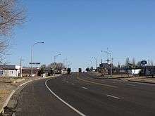
The route next heads northwest to Vaughn where it has a brief concurrency with US 54 and US 60. The route then continues northwest and has a junction with Interstate 40 (I-40) at Clines Corners.

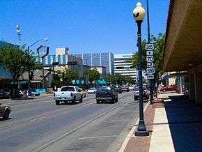
Heading north out of Clines Corners, the route continues towards the state capital. At the outskirts of Santa Fe, the route becomes concurrent with I-25, US 84, and its unsigned parent (US 85) for several miles heading west through the foothills of the Sangre De Cristo Mountains to Santa Fe. After exiting I-25, US 285 follows Saint Francis Drive through Santa Fe. The route continues north by northwest to Española and Chamita, where the concurrency with US 84 ends. The route then traverses the Carson National Forest where US 285 now makes a long climb up to the Colorado Plateau, passing through Ojo Caliente as it ascends to the San Luis Valley. After crossing US 64, the highway passes through the village of Tres Piedras, New Mexico at the south end of the valley, then proceeds north to the Colorado border near the Rio Grande del Norte National Monument.
Major intersections
| County | Location | mi | km | Exit | Destinations | Notes | ||
|---|---|---|---|---|---|---|---|---|
| Eddy | | 0.00 | 0.00 | Continuation into Texas | ||||
| Loving | 21.1 | 34.0 | Southern terminus of NM 387 | |||||
| | 23.4 | 37.7 | Southern terminus of NM 31 | |||||
| | 27.3 | 43.9 | Southern terminus of NM 216 | |||||
| Carlsbad | 31.3 | 50.4 | South end of US 62/US 180 overlap | |||||
| 32.0 | 51.5 | Northern terminus of NM 216 | ||||||
| 32.6 | 52.5 | Plaza Street | Interchange; southbound exit only via San Jose Boulevard | |||||
| 33.1 | 53.3 | Eastern terminus of NM 524 | ||||||
| 33.3 | 53.6 | North end of US 62/US 180 overlap | ||||||
| | 41.6 | 66.9 | Western terminus of NM 524 | |||||
| | 45.7 | 73.5 | Northern terminus of NM 137 | |||||
| | 55.1 | 88.7 | Western terminus of NM 381 | |||||
| | 63.4 | 102.0 | Southern terminus of NM 229 | |||||
| Atoka | 64.4 | 103.6 | Western terminus of NM 335 | |||||
| Artesia | 69.4 | 111.7 | ||||||
| 70.4 | 113.3 | Western terminus of NM 357 | ||||||
| 71.4 | 114.9 | Northern terminus of NM 229 | ||||||
| | 72.1 | 116.0 | Southern terminus of NM 2 | |||||
| | 77.2 | 124.2 | ||||||
| Eddy–Chaves county line | | 78.6 | 126.5 | |||||
| Chaves | | 86.7 | 139.5 | Eastern terminus of NM 13 | ||||
| | 102.1 | 164.3 | Northern terminus of NM 2 | |||||
| | 105.1 | 169.1 | Southern terminus of US 285 Truck (Relief Rte.) | |||||
| Roswell | 109.7 | 176.5 | South end of US 70 overlap | |||||
| 113.7 | 183.0 | Eastern terminus of NM 246 | ||||||
| | 115.0 | 185.1 | Interchange; north end of US 70 overlap; US 70 exit B, US 70 Truck exit A; eastern terminus of US 70 Truck, northern terminus of US 285 Truck (Relief Rte.) | |||||
| | 146.8 | 236.3 | Southern terminus of NM 20 | |||||
| De Baca | | 166.3 | 267.6 | Eastern terminus of NM 247 | ||||
| Lincoln |
No major junctions | |||||||
| Guadalupe | | 204.7 | 329.4 | South end of US 54/US 60 overlap | ||||
| | 208.6 | 335.7 | North end of US 54 overlap | |||||
| Torrance | Encino | 222.2 | 357.6 | |||||
| 222.7 | 358.4 | North end of US 60 overlap | ||||||
| Clines Corners | 249.4 | 401.4 | I-40 exit 218 | |||||
| San Miguel |
No major junctions | |||||||
| Santa Fe | | 265.7 | 427.6 | Southern terminus of NM 34 | ||||
| | 284.0 | 457.1 | Northern terminus of NM 41 | |||||
| Eldorado at Santa Fe | 290.7 | 467.8 | South end of I-25/US 84/US 85 overlap; I-25 exit 290 | |||||
| Santa Fe | 297.1 | 478.1 | 284 | Exit number follows I-25 | ||||
| 298.4 | 480.2 | North end of I-25/US 85 overlap; I-25 exit 282 | ||||||
| 300.0 | 482.8 | Interchange; serves CHRISTUS St. Vincent Regional Medical Center | ||||||
| 301.6 | 485.4 | Northern terminus of NM 14 | ||||||
| 302.5 | 486.8 | Western terminus of NM 475 | ||||||
| 303.2 | 488.0 | Downtown Plaza | Interchange; southbound exit and northbound entrance | |||||
| 303.8 | 488.9 | 166 | Northern terminus of NM 599; south end of freeway; no exit number northbound | |||||
| Santa Fe–Tesuque line | 306.2 | 492.8 | 168 | Southern terminus of CR 73 | ||||
| Tesuque–Tesuque Pueblo line | 308.1 | 495.8 | 171 | Flea Market Road | ||||
| Tesuque Pueblo | 309.2 | 497.6 | 172 | Northern terminus of CR 73 | ||||
| | 312.3 | 502.6 | 175 | Camel Rock Road | ||||
| Cuyamungue | 313.9 | 505.2 | 176 | Cuyamungue | ||||
| 315.3 | 507.4 | 177 | North end of freeway | |||||
| Pojoaque | 317.8 | 511.4 | Eastern terminus of NM 502; interchange | |||||
| 318.5 | 512.6 | Western terminus of NM 503 | ||||||
| | 320.4 | 515.6 | 183 | Frontage Road | Interchange | |||
| Sombrillo–Española line | 324.5 | 522.2 | Northern terminus of NM 399, southern terminus of NM 106 | |||||
| Rio Arriba | Española | 326.1 | 524.8 | Southern terminus of NM 68 | ||||
| 326.9 | 526.1 | Northern terminus of NM 30 | ||||||
| 328.3 | 528.3 | Western terminus of NM 584 | ||||||
| | 333.3 | 536.4 | Western terminus of NM 74 | |||||
| | 334.9 | 539.0 | North end of US 84 overlap | |||||
| Taos | Ojo Caliente | 351.3 | 565.4 | Southern terminus of NM 414 | ||||
| | 353.0 | 568.1 | Southern terminus of NM 111 | |||||
| | 361.9 | 582.4 | Western terminus of NM 567 | |||||
| Tres Piedras | 382.3 | 615.3 | ||||||
| | 407.0 | 655.0 | Continuation into Colorado | |||||
1.000 mi = 1.609 km; 1.000 km = 0.621 mi
| ||||||||
Gallery
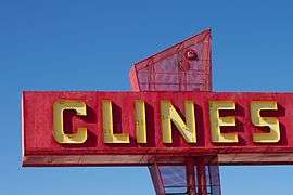 Clines Corners, at the junction of US-285 and I-40, south of Sante Fe