Interstate 40 in New Mexico
Interstate 40 (I-40), a major east–west route of the Interstate Highway System, runs east–west through Albuquerque in the U.S. state of New Mexico. It is the direct replacement for the historic U.S. Highway 66 (US 66).
| ||||
|---|---|---|---|---|
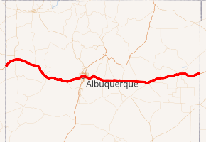
I-40 highlighted in red | ||||
| Route information | ||||
| Maintained by NMDOT | ||||
| Length | 373.530 mi[1] (601.138 km) | |||
| Existed | 1957[2]–present | |||
| Major junctions | ||||
| West end | ||||
| ||||
| East end | ||||
| Location | ||||
| Counties | McKinley, Cibola, Bernalillo, Santa Fe, Torrance, Guadalupe, Quay | |||
| Highway system | ||||
| ||||
.svg.png)
Route description
Arizona to Albuquerque

As I-40 enters New Mexico in a northeasterly direction it begins following the basin of the intermittent Puerco River (Rio Puerco of the West, as opposed to the Rio Puerco of the East that it crosses near Albuquerque), roughly tracing the southern edge of the contiguous part of the Navajo Reservation in the state. The freeway enters Gallup twenty miles (32 km) later paralleling the Burlington Northern Santa Fe Railway's southern transcontinental mainline. Leaving Gallup the now more easterly I-40 passes to the north of Fort Wingate and part of the fragmented Cibola National Forest before crossing the North American continental divide at an elevation of 7,275 ft (2,217 m), with 11,305 ft (3,446 m) stratovolcano Mt. Taylor towering to the east.
The highway traverses more of the Navajo Reservation and the Cibola Forest before turning southeast and crossing a malpaís. After serving interchanges near Grants, the freeway, coinciding with the northern boundary of El Malpais National Monument, crosses another malpaís, turns east and enters the Acoma Indian Reservation, home of the Acoma Pueblo. The route leaves the Acoma Indian Reservation with Mt. Taylor to the north and enters the Laguna Pueblo. Near the interchange with New Mexico State Road 6 (NM 6) the railway line that accompanies much of the route from the Arizona border diverts to the south while the freeway turns east by northeast towards Albuquerque. The route departs the Laguna Pueblo, briefly transits the Tohajiilee Indian Reservation (a chapter of the Navajo Nation), crosses the Rio Puerco and begins a steep climb to the top of a mesa marked by several small cinder cones overlooking the Rio Grande rift and Albuquerque.
From Laguna to the Route 66 Casino, I-40 has at-grade intersections with a number of ranch access roads in violation of Interstate Highway standards. These intersections are a vestige that remain from the conversion of US 66 to I-40 during the latter part of the 20th century.
Albuquerque Metro Area
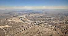
Interstate 40 diverges from the former US 66 alignment (Central Avenue) at an interchange with Atrisco Vista Boulevard on the West Mesa that overlooks Albuquerque. I-40 descends Nine Mile Hill as it enters the city of Albuquerque, and intersects 98th Street, Unser Boulevard (NM 345) and Coors Boulevard (NM 45) before crossing the Rio Grande. The freeway then skirts the northern edge of downtown Albuquerque before intersecting Interstate 25 at a 5-level stack interchange (Big I). East of I-25, I-40 continues east, then turns southeast passing through Uptown before intersecting Old US 66 (now signed as NM 333/Central Avenue) at Tramway Boulevard (NM 556) as it leaves Albuquerque and enters Tijeras Canyon. This section of I-40 is also referred to as the Coronado Freeway.
Albuquerque to Texas

East of Albuquerque, Interstate 40 crosses the Sandia–Manzano Mountains by traversing Tijeras Pass, reaching its highest point of 7,200 feet at Sedillo Ridge. Continuing east, I-40 descends out of the mountains and into the Estancia Valley while passing through the town of Edgewood (m.m. 187). The highway continues east across the Estancia Valley, passing through Moriarty (m.m. 194). Before reaching Clines Corners, I-40 ascends into the Pedrenal Hills, a region of hills and low-level ridgelines averaging around 7,000 feet in elevation. East of Clines Corners,( m.m. 217) I-40 gradually descends from the Pedrenal Hills region and into the High Plains of eastern New Mexico. At Santa Rosa (m.m. 273) I-40 crosses the Pecos River, and then continues east-northwastward co-signed with US 54 to Tucumcari. At Tucumcari, I-40 diverges from US 54 and turns eastward and skirts the northern edge of San Jon before reaching the Texas state line at Glenrio.
History
Planning and construction of Interstate 40 through New Mexico began shortly after the Federal Highway Act of 1956 created the Interstate Highway System. First sections of I-40 through the state were completed by 1960 including a short section west of Tucumcari in Quay County, from a point just west of Santa Rosa west past Clines Corners to just east of Moriarty, along with a section on the east side of Albuquerque and another section from near Cubero to Grants, which included a new spur route connecting the Interstate Highway with U.S. 66 on that city's east side. Construction of I-40, generally paralleling the existing U.S. 66 in some sections and replacing the older route in others, was hobbled for a few years during this decade by the New Mexico Legislature's passage of an Anti-Bypassing Law that prohibited the construction of an interstate bypass around a city or town opposed to it. That law was repealed in 1966 following a threat of loss of federal funds and most New Mexico cities along I-40, I-25 and I-10 then worked out agreements with state and federal highway officials in determining where the bypass routes around their municipalities should be located.
By the end of the 1960s, most rural sections of I-40 were completed across the state with the largest exception being a 40-mile (64 km) stretch east of Tucumcari to the Texas border at Glenrio, where traffic was diverted to the old U.S. 66. That section of highway by this time became locally and nationally known as "Slaughter Lane" due to tremendous amounts of traffic for a two-lane highway along with rough and narrow paving which led to numerous injury and fatal traffic accidents that reached epidemic numbers in 1968 and 1969.[3] Construction on this section of I-40 was held up by a dispute at San Jon concerning a proposed routing of I-40 bypassing that city to the north by some five miles (8 km), which was resolved in November 1969 when federal and state officials agreed to bring the bypass closer to the city along its northern limits. However, aside from a few small villages such as Montoya, Newkirk and Cuervo in the eastern portion of the state and Laguna, Budville and Cubero to the west, no major bypasses had been entirely completed in New Mexico so traffic was still diverted over the U.S. 66 routes through each of those cities.
In 1970, I-40 was entirely completed through the city of Albuquerque. Other bypasses were completed around various cities through the state including San Jon (1976)[4] and Tucumcari (1981),[4] Santa Rosa (1972), Moriarty (1973), Grants (1974) and Gallup (1980).[5]
Exit list
| County | Location | mi[6] | km | Exit[7] | Destinations | Notes |
|---|---|---|---|---|---|---|
| McKinley | | 0.00 | 0.00 | Continuation into Arizona | ||
| | 8.36 | 13.45 | 8 | |||
| Gallup | 16.36 | 26.33 | 16 | Western terminus of former I-40 Bus. | ||
| 20.73 | 33.36 | 20 | US 491/NM 602 not signed westbound; westbound entrance includes direct entrance ramp from Maloney Avenue; former US 666 | |||
| 22.66 | 36.47 | 22 | Miyamura Drive / Montoya Boulevard | |||
| 25.83 | 41.57 | 26 | Eastern terminus of former I-40 Bus. | |||
| McGaffey | 33.52 | 53.95 | 33 | |||
| Iyanbito | 36.67 | 59.01 | 36 | Eastern terminus of NM 118 | ||
| | 39.75 | 63.97 | 39 | Refinery | ||
| Coolidge | 44.51 | 71.63 | 44 | Coolidge | ||
| | 47.81 | 76.94 | 47 | Western terminus of NM 122 | ||
| Thoreau | 53.17 | 85.57 | 53 | |||
| Prewitt | 63.18 | 101.68 | 63 | |||
| Cibola | Bluewater Village | 72.05 | 115.95 | 72 | ||
| Milan | 78.93 | 127.03 | 79 | Western terminus of former I-40 Bus.; access to NM 122 via Horizon Boulevard | ||
| Grants | 81.71 | 131.50 | 81 | Signed as exits 81A (south) and 81B (north) eastbound | ||
| 84.95 | 136.71 | 85 | Eastern terminus of NM 122, eastern terminus of former I-40 Bus. | |||
| | 89.26 | 143.65 | 89 | |||
| | 96.33 | 155.03 | 96 | McCartys, Acoma, Sky City | NM 124 not signed; former US 66 | |
| San Fidel | 99.86 | 160.71 | 100 | San Fidel | ||
| | 101.69 | 163.65 | 102 | Acomita, Acoma, Sky City | ||
| | 104.60 | 168.34 | 104 | Cubero, Budville, Seama | ||
| | 107.74 | 173.39 | 108 | Casa Blanca, Paraje | ||
| Laguna | 113.99 | 183.45 | 114 | Eastern terminus of NM 124; former US 66 | ||
| | 117.47 | 189.05 | 117 | Mesita | ||
| | 126.53 | 203.63 | 126 | |||
| Cañoncito | 130.98 | 210.79 | 131 | To'hajiilee | ||
| Bernalillo | | 140.05 | 225.39 | 140 | Rio Puerco | |
| | 149.25 | 240.19 | 149 | Atrisco Vista Boulevard | Former NM 500 | |
| Albuquerque | 151.98 | 244.59 | 153 | 98th Street / Arroyo Vista Blvd | ||
| 153.10 | 246.39 | 154 | ||||
| 154.76 | 249.06 | 155 | ||||
| 156.67 | 252.14 | 157A | Rio Grande Boulevard | |||
| 157.39 | 253.29 | 157B | 12th Street | Eastbound exit and westbound entrance; westbound access via exit 158 | ||
| 157.85 | 254.03 | 158 | 8th Street / 6th Street | No westbound entrance | ||
| 158.02 | 254.31 | 159A | 4th Street / 2nd Street / University Boulevard | Eastbound exit and westbound entrance | ||
| 159.05 | 255.97 | 159B-C | Signed as exits 159B (south) and 159C (north); I-25 exits 226A-B; serves Albuquerque International Sunport and Presbyterian Hospital | |||
| 159.38 | 256.50 | 159D | Westbound exit and eastbound entrance; serves University of New Mexico Hospital | |||
| 160.50 | 258.30 | 160 | Carlisle Boulevard | |||
| 161.46 | 259.84 | 161 | San Mateo Boulevard | |||
| 162.62 | 261.71 | 162 | Louisiana Boulevard | |||
| 163.75 | 263.53 | 164 | Wyoming Boulevard | |||
| 164.19 | 264.24 | Lomas Boulevard | Former westbound exit and eastbound entrance from eastbound Lomas Boulevard; replaced by completion of Wyoming Boulevard interchange | |||
| 164.90 | 265.38 | 165 | Eubank Boulevard | |||
| 165.97 | 267.10 | 166 | Juan Tabo Boulevard | |||
| 167.10– 167.30 | 268.92– 269.24 | 167 | Historic US 66 (Central Ave.) not signed eastbound | |||
| | 168.87 | 271.77 | 170 | |||
| | 173.90– 177.42 | 279.86– 285.53 | 175 | |||
| Zuzax | 177.17 | 285.13 | 178 | |||
| Sedillo | 181.04 | 291.36 | 181 | |||
| Santa Fe | Edgewood | 186.73 | 300.51 | 187 | ||
| Torrance | Moriarty | 194.55 | 313.10 | 194 | ||
| 195.93 | 315.32 | 196 | ||||
| 197.33 | 317.57 | 197 | No westbound entrance | |||
| | 203.38 | 327.31 | 203 | Longhorn Ranch | Exit does not sign this destination | |
| Wagon Wheel | 208.39 | 335.37 | 208 | Wagon Wheel | ||
| Clines Corners | 217.59 | 350.18 | 218A | Clines Corners | Former westbound exit only (closed and removed 2015) | |
| 218 | ||||||
| | 225.81 | 363.41 | 226 | Palma | Exit does not sign this destination | |
| | 230.17 | 370.42 | 230 | |||
| | 233.71 | 376.12 | 234 | Flying C | Exit does not sign this destination; westbound has two separate exits with the same number and destination | |
| | 238.69 | 384.13 | 239 | McKenzie | Exit does not sign this destination | |
| Guadalupe | | 242.83 | 390.80 | 243 | Milagro | Exit does not sign this destination; signed as exits 243B and 243A westbound |
| | 251.58 | 404.88 | Eastbound Rest Stop | |||
| | Vaughn Route 66 Rest Stop; exit 252 | |||||
| | 255.86 | 411.77 | 256 | Northern terminus of NM 219; western end of US 84 concurrency | ||
| San Ignacio | 262.83 | 422.98 | 263 | San Ignacio | ||
| Colonias | 267.16 | 429.95 | 267 | Colonias | ||
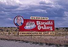
| Santa Rosa | 272.38 | 438.35 | 273 | I-40 Bus. not signed westbound | ||
| 274.37 | 441.56 | 275 | Santa Rosa (I-40 Bus. / US 54) | |||
| 276.19 | 444.48 | 277 | Eastern end of US 84 concurrency; western end of US 54 concurrency; I-40 Bus./US 54 not signed eastbound | |||
| | 283.96 | 456.99 | 284 | Frontier Museum | ||
| Cuervo | 290.61– 291.21 | 467.69– 468.66 | 291 | Cuervo | ||
| Newkirk | 299.27 | 481.63 | 300 | |||
| Quay | Montoya | 310.72 | 500.06 | 311 | Montoya | |
| Palomas | 321.13 | 516.81 | 321 | Palomas | ||
| Tucumcari | 328.43 | 528.56 | 329 | Western terminus of I-40 Bus. | ||
| 330.30 | 531.57 | 331 | Camino del Coronado | |||
| 331.45 | 533.42 | 332 | ||||
| 332.80 | 535.59 | 333 | Eastern end of US 54 concurrency | |||
| 334.67 | 538.60 | 335 | ||||
| | 337.81 | 543.65 | 339 | |||
| | 343.13 | 552.21 | 343 | Quay Road AD | Exit does not sign this road | |
| San Jon | 355.25 | 571.72 | 356 | |||
| Bard | 360.35 | 579.93 | 361 | Bard | ||
| Endee | 369.02 | 593.88 | 369 | |||
| Glenrio | 372.52 | 599.51 | Continuation into Texas | |||
1.000 mi = 1.609 km; 1.000 km = 0.621 mi
| ||||||
References
- "Interstate Routes" (PDF). New Mexico Department of Transportation. Archived from the original (PDF) on July 23, 2011. Retrieved December 2, 2010.
- Public Roads Administration (August 14, 1957). Official Route Numbering for the National System of Interstate and Defense Highways, As Adopted by the American Association of State Highway Officials (Map). Scale not given. Washington, DC: Public Roads Administration. Retrieved June 16, 2011 – via Wikimedia Commons.
- "Historic Route 66: The Mother Road" (PDF). County Star-News. Shamrock, TX. March 15, 2012. pp. E2–E8.
- "Route 66 History Page". www.route66world.com.
- Sonderman, Joe (2016). Route 66 Roadside Signs and Advertisements. Voyageur Press. p. 89.
- New Mexico Department of Transportation (2007). Statewide Milepost/Point Map (PDF) (Map). Scale not given. Santa Fe: New Mexico Department of Transportation. Archived from the original (PDF) on July 22, 2013.
- "TIMS Road Segments by Posted Route/Point with AADT Info: I-Routes" (PDF). New Mexico Department of Transportation. June 8, 2016. Retrieved September 5, 2019.
External links

| Previous state: Arizona |
New Mexico | Next state: Texas |