Duran, New Mexico
Duran is a census-designated place in Torrance County, New Mexico, United States. Duran is located at the junction of U.S. Route 54 and New Mexico State Road 3 14 miles (23 km) southwest of Vaughn. As of the 2010 census, its population was 35.[2]
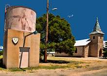
Fire Department Water Tower
Duran, New Mexico | |
|---|---|
Census-designated place | |
 Duran, New Mexico | |
| Coordinates: 34°28′02″N 105°23′49″W | |
| Country | United States |
| State | New Mexico |
| County | Torrance |
| Area | |
| • Total | 4.692 sq mi (12.15 km2) |
| • Land | 4.692 sq mi (12.15 km2) |
| • Water | 0 sq mi (0 km2) |
| Elevation | 6,276 ft (1,913 m) |
| Population (2010)[2] | |
| • Total | 35 |
| • Density | 7.5/sq mi (2.9/km2) |
| Time zone | UTC-7 (Mountain (MST)) |
| • Summer (DST) | UTC-6 (MDT) |
| Area code(s) | 575 |
| GNIS feature ID | 898762[3] |
History
Duran was laid out in 1902 when the railroad was extended to that point.[4] A post office has been in operation at Duran since 1902.[5]
References
- "US Gazetteer files: 2010, 2000, and 1990". United States Census Bureau. 2011-02-12. Retrieved 2011-04-23.
- "U.S. Census website". United States Census Bureau. Retrieved 2011-05-14.
- "Duran". Geographic Names Information System. United States Geological Survey.
- Harris, Linda G. (2003). Ghost Towns Alive: Trips to New Mexico's Past. UNM Press. p. 111. ISBN 978-0-8263-2908-0.
- "Torrance County". Jim Forte Postal History. Retrieved 29 October 2015.
Municipalities and communities of Torrance County, New Mexico, United States | ||
|---|---|---|
| City | 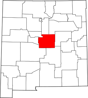 Map of New Mexico highlighting Torrance County | |
| Towns | ||
| Village | ||
| CDPs | ||
| Other unincorporated communities | ||
| Footnotes | ‡This populated place also has portions in an adjacent county or counties | |
This article is issued from Wikipedia. The text is licensed under Creative Commons - Attribution - Sharealike. Additional terms may apply for the media files.