Tieri
Tieri /tiˈɛəri/ is a small mining town and locality in the Central Highlands Region, Queensland, Australia.[2][3] Established in 1983, the town like nearby Middlemount and Dysart, is a service centre for local coal mines. In the 2016 census, Tieri had a population of 1,129 people.[1]
| Tieri Queensland | |||||||||||||||
|---|---|---|---|---|---|---|---|---|---|---|---|---|---|---|---|
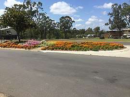 Tieri streetscape, September 2016 | |||||||||||||||
 Tieri Location in Queensland | |||||||||||||||
| Coordinates | 23°02′06″S 148°20′54″E | ||||||||||||||
| Population | 1,129 (2016 census)[1] | ||||||||||||||
| Established | 1983 | ||||||||||||||
| Postcode(s) | 4709 | ||||||||||||||
| Location | |||||||||||||||
| LGA(s) | Central Highlands Region | ||||||||||||||
| State electorate(s) | Gregory | ||||||||||||||
| Federal Division(s) | Capricornia | ||||||||||||||
| |||||||||||||||
Geography
The locality is an "island" within the locality of Lilyvale. The German Creek (towards Middlemount), Oaky Creek Coal No.1 & North and Gregory Crinum mines (Emerald) are close to Tieri.[4]
History
At the 2011 census, Tieri had a population of 2012.[5]
Heritage listings
Tieri has a number of heritage-listed sites, including:
- Talagai Avenue: Tieri War Memorial[6]
Education
Tieri State School opened on 24 January 1983.[7] The school motto is 'Strive for Success'.[8] Their Annual Report states the school is coeducational and has 187 students enrolled.[9]
Amenities
According to an early resident there were no facilities when people moved to the town.[10] There were no shops and a bank visited once a week. Tieri now has a whole range of shops for a mining town. Tieri has bush trails for mountain, quad and dirt bikes. The nearest purpose built motorcross track is in Middlemount approximately 40 km away.
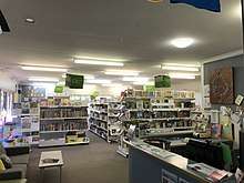
Central Highlands Regional Council operates Tieri Library at the corner of Grasstree and Anncrouye Streets, Tieri.[11]
See also
References
- Australian Bureau of Statistics (27 June 2017). "Tieri (SSC)". 2016 Census QuickStats. Retrieved 25 October 2018.

- "Tieri - town (entry 34525)". Queensland Place Names. Queensland Government. Retrieved 5 March 2016.
- "Tieri - locality (entry 46980)". Queensland Place Names. Queensland Government. Retrieved 5 March 2016.
- "Queensland Globe". State of Queensland. Retrieved 25 October 2018.
- Australian Bureau of Statistics (31 October 2012). "Tieri (State Suburb)". 2011 Census QuickStats. Retrieved 5 March 2016.
- "Tieri War Memorial (entry 602184)". Queensland Heritage Register. Queensland Heritage Council. Retrieved 7 July 2013.
- "Opening and closing dates of Queensland Schools". Queensland Government. Retrieved 18 April 2019.
- "Tieri State School". Education Queensland. Retrieved 30 January 2017.
- "Tieri State School Annual Report" (PDF). Education Queensland. Retrieved 30 January 2017.
- Murray, Georgina; David Peetz (2010). Women of the Coal Rushes. UNSW Press. p. 74. ISBN 1742232213. Retrieved 5 March 2016.
- "Tieri Library". Public Libraries Connect. State Library of Queensland. 8 September 2016. Retrieved 31 January 2018.
External links
![]()
- University of Queensland: Queensland Places: Tieri
- Tieri State School website
- Tieri State School on Facebook