Springsure
Springsure is a town and a locality in the Central Highlands Region, Queensland, Australia.[2][3] It is 66 kilometres (41 mi) south of Emerald on the Gregory Highway. It is the southern terminus of the Gregory Highway and the northern terminus of the Dawson Highway. It is 765 kilometres (475 mi) northwest of Brisbane. In the 2016 census, Springsure had a population of 1,103 people.[1]
| Springsure Queensland | |||||||||||||||
|---|---|---|---|---|---|---|---|---|---|---|---|---|---|---|---|
 Entrance sign, Springsure, Queensland | |||||||||||||||
 Springsure | |||||||||||||||
| Coordinates | 24.1161°S 148.0886°E | ||||||||||||||
| Population | 1,103 (2016 census)[1] | ||||||||||||||
| • Density | 7.790/km2 (20.175/sq mi) | ||||||||||||||
| Postcode(s) | 4722 | ||||||||||||||
| Elevation | 344.9 m (1,132 ft) | ||||||||||||||
| Area | 141.6 km2 (54.7 sq mi) | ||||||||||||||
| Time zone | AEST (UTC+10:00) | ||||||||||||||
| Location | |||||||||||||||
| LGA(s) | Central Highlands Region | ||||||||||||||
| State electorate(s) | Gregory | ||||||||||||||
| Federal Division(s) | Flynn | ||||||||||||||
| |||||||||||||||
| |||||||||||||||
Geography
Today, Springsure is a pastoral settlement serving cattle farms, and sunflower, sorghum, wheat and chickpea plantations.
Springsure is the hub for several coal mines such as the Minerva Mine and the Rolleston Mine. Significant exploration is ongoing in the district. It is also a staging point for expeditions to the Carnarvon National Park.
History
Gangalu (Gangulu, Kangulu, Kanolu, Kaangooloo, Khangulu) is an Australian Aboriginal language spoken on Gangula country. The Gangula language region includes the towns of Clermont and Springsure extending south towards the Dawson River.[4]
Wadja (also known as Wadjigu, Wadya, Wadjainngo, Mandalgu, and Wadjigun) is an Australian Aboriginal language in Central Queensland. The language region includes the local government areas of the Aboriginal Shire of Woorabinda and Central Highlands Region, including the Blackdown Tablelands. the Comet River, and the Expedition Range, and the towns of Woorabinda, Springsure and Rolleston.[5]
The town takes its name from a pastoral run name used from 1861, so named because of a permanent spring on the run.[2][3]
The area was originally occupied by Aboriginal people, for thousands of years.
Ludwig Leichhardt was the first European to explore the area between 1843 and 1845. His favourable reports encouraged settlers to move in and settle the land whose domains were those of Aboriginal groups.
In 1861 squatter Horatio Wills and a party of Victorian settlers arrived near modern-day Springsure in 1861. Two weeks later, 19 men women and children, including Wills, were killed by Aboriginal Australian people, the Kairi or Gayiri, in the Cullin-La-Ringo massacre, the largest massacre of European settlers by Aborigines in Australian history.[6] At least 15 Aboriginal men, women and children were killed[7] by the Queensland Native Police and militias of local European colonists and their employees, in a series of reprisals over the months that followed. However, the massacre of the 19 European family members was itself a retaliatory response to an earlier shooting of fugitive murderer who was Gayiri tribesman by Jesse Gregson (manager of nearby Rainsworth Station) with Second Lieutenant Alfred March Patrick and Native Police Troops in his command.[8] Prior to the massacre of the 19 colonists, Second Lieutenant Patrick had complained, in early 1861, to Charles Dutton (lessee of Bauhinia Downs pastoral lease 148 km south-east of Springsure) that other officers in the Queensland Native Police "...had been able to bag their first Aborigine after only a few weeks in the Force; he had served for six months and still had not yet killed a black."[9] The Old Rainworth Fort was built in 1862 by the colonists of Springsure in order to defend themselves from future raids by Aboriginals. Horatio's son, star cricketer and Australian rules football pioneer Tom Wills, survived the massacre, and remained on site until 1864.
The town was surveyed by Charles Frederick Gregory in August 1863.[2]
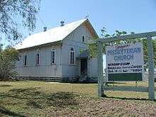
The Springsure Presbyterian Church in Charles Street opened about 1866. It closed in March 2011 after 145 years.[10]
Springsure State School opened on 14 March 1870.[11]
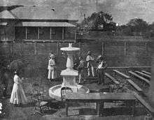
On 6 December 1919, the Springsure State School Memorial Fountain was dedicated by Mrs Annie Wheeler (née Laurie), a former pupil at the school. The memorial is a marble fountain and commemorates students of the school who served in World War I.[12][13]
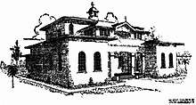

In March 1925 the Rev. Father Thomas Andrew Sweeney arrived in Springsure to replace Rev. Father Bucas as the Catholic priest for the parish.[14] Sweeney saw there was a need for a Catholic school in Springure and set about building a school and a convent for its teachers in August 1925.[15] The architect was Roy Chipps and the builder E.H. Fletcher (both of Rockhampton). In January 1926 the school and the convent opened in a ceremony led by Roman Catholic Bishop of Rockhampton, Joseph Shiel. The convent and school were under the control of Sister Mary Bonaventure of the Sisters of Mercy.[16] The school opened on 2 February 1926 with 64 children.[17][18] It was originally known as The Convent of the Little Flower,[19] but later changed to Our Lady of the Sacred Heart.[20]
On 16 November 1943 a Douglas C-47A Skytrain broke up in mid-air during a violent storm in the area, and crashed on Rewan Station, just south of Springsure.[21] All 19 people on board the aircraft perished in the crash.[21]
At the 2006 census, Springsure had a population of 829.[22]
Heritage listings
.jpg)
Springsure has a number of heritage-listed sites, including:
- 13 Woodbine Street: Springsure Hospital Museum[23]
- Wealwandangie Road, Cairdbeign: Old Rainworth Stone Store[24]
Attractions
A cliff face in the hills surrounding Springsure is known to the area as Virgin Rock, named because it once looked like the Virgin Mary cradling the baby Jesus, although years of erosion have blurred the original resemblance.
Facilities
Facilities at Springsure include an airport, caravan park, hospital, motocross track, police station, service station and showground.
The Central Highlands Regional Council operate a public library in Springsure at 27 Eclipse Street.[25]
The Springsure branch of the Queensland Country Women's Association has its rooms at 27 Eclipse Street.[26]
Education
Springsure State School is a government primary and secondary (Prep-10) school for boys and girls at 55 Eclipse Street (24.1157°S 148.0885°E).[27][28] In 2017, the school had an enrolment of 158 students with 21 teachers (16 full-time equivalent) and 14 non-teaching staff (8 full-time equivalent).[29] Their school motto is 'Success by Effort'.[30]
Our Lady of the Sacred Heart Catholic Primary School is a Catholic primary (Prep-6) school for boys and girls at Gap Street (24.1170°S 148.0926°E).[27][31] In 2017, the school had an enrolment of 50 students with 7 teachers (6 full-time equivalent) and 6 non-teaching staff (2 full-time equivalent).[29]
There is no secondary education to Year 12 in Springsure; the nearest school offering secondary education to Year 12 is in Emerald.[18]
Notable residents
- John Denis Fryer after whom the Fryer Library at the University of Queensland is named
- John Humphreys, Olympic fencer
- Roy Moore, U.S. judge and Senate candidate, worked on the Telemon cattle station outside town in 1984.
- Keith Slater, Anglican priest in Springsure, later Bishop of Grafton
- Theophilus Wilson, cricketer
Gallery
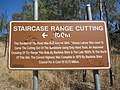 Staircase Range Cutting, near Springsure, Queensland - information sign
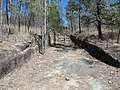 Staircase Range Cutting, near Springsure, Queensland
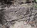 Staircase Range Cutting, near Springsure, Queensland - detail of hand tooling
See also

References
- Australian Bureau of Statistics (27 June 2017). "Springsure (SSC)". 2016 Census QuickStats. Retrieved 20 October 2018.

- "Springsure - town in Central Highlands Region (entry 31998)". Queensland Place Names. Queensland Government. Retrieved 8 August 2017.
- "Springsure - locality in Central Highlands Region (entry 46976)". Queensland Place Names. Queensland Government. Retrieved 8 August 2017.
-

-
- "ROCKHAMPTON". The Courier. Brisbane: National Library of Australia. 11 November 1861. p. 2. Retrieved 13 May 2014.
- T. Bottoms (2013) Conspiracy of Silence: Queensland's frontier killing times, Allen & Unwin, pp.53-54
- T Bottoms (2013) Conspiracy of Silence: Queensland's frontier killing times, Allen & Unwin, p.54
- G. Reid, "From Hornet Bank to Cullin-La-Ringo", Royal Historical Society of Queensland, 18 May 1981, p.69
- Carson, Julie-Ann (30 March 2011). "Church closes after 145 years". CQ News. Archived from the original on 10 June 2019. Retrieved 10 June 2019.
- "Opening and closing dates of Queensland Schools". Queensland Government. Retrieved 18 April 2019.
- "SOLDIERS' MEMORIAL MARBLE FOUNTAIN". The Morning Bulletin. Rockhampton, Qld.: National Library of Australia. 13 December 1919. p. 7. Retrieved 6 April 2014.
- "Springsure State School Memorial Fountain". Monument Australia. Archived from the original on 7 April 2014. Retrieved 6 April 2014.
- "PERSONAL". The Brisbane Courier (20, 958). Queensland, Australia. 26 March 1925. p. 10. Retrieved 10 June 2019 – via National Library of Australia.
- "OPPORTUNITIES". Construction And Local Government Journal. XXXIII (915). New South Wales, Australia. 19 August 1925. p. 18. Retrieved 10 June 2019 – via National Library of Australia.
- "SPRINGSURE CATHOLICITY". Morning Bulletin (19171). Queensland, Australia. 26 January 1926. p. 11. Retrieved 10 June 2019 – via National Library of Australia.
- "NEW BUILDINGS AT SPRINGSURE". The Capricornian. LI (7). Queensland, Australia. 13 February 1926. p. 8 (THE CAPRICORNIAN.). Retrieved 10 June 2019 – via National Library of Australia.
- Queensland Family History Society (2010), Queensland schools past and present (Version 1.01 ed.), Queensland Family History Society, ISBN 978-1-921171-26-0
- "SPRINGSURE". The Catholic Press (1571). New South Wales, Australia. 18 February 1926. p. 29. Retrieved 10 June 2019 – via National Library of Australia.
- "Our History". Our Lady of the Sacred Heart Catholic Primary School. Archived from the original on 10 June 2019. Retrieved 10 June 2019.
- Dunn, Peter. "16 NOVEMBER 1943 CRASH OF A C-47A DAKOTA ON REWAN STATION SOUTH OF SPRINGSURE, QLD". www.AustraliaAtWar.com. Archived from the original on 3 January 2013. Retrieved 22 December 2012.
- Australian Bureau of Statistics (25 October 2007). "Springsure (State Suburb)". 2006 Census QuickStats. Retrieved 25 June 2011.
- "Springsure Hospital Museum (entry 600025)". Queensland Heritage Register. Queensland Heritage Council. Retrieved 7 July 2013.
- "Old Rainworth Stone Store (entry 600026)". Queensland Heritage Register. Queensland Heritage Council. Retrieved 7 July 2013.
- "Locations". Central Highlands Regional Council. Archived from the original on 31 January 2018. Retrieved 31 January 2018.
- "Branch locations". Queensland Country Women's Association. Archived from the original on 26 December 2018. Retrieved 26 December 2018.
- "State and non-state school details". Queensland Government. 9 July 2018. Archived from the original on 21 November 2018. Retrieved 21 November 2018.
- "Springsure State School". Retrieved 21 November 2018.
- "ACARA School Profile 2017". Archived from the original on 22 November 2018. Retrieved 22 November 2018.
- "Springsure State School". Education Queensland. Archived from the original on 3 February 2017. Retrieved 2 February 2017.
- "Our Lady of the Sacred Heart Catholic Primary School". Retrieved 21 November 2018.
External links
![]()